Yellowfin fishing at the Hudson Canyon is an overnight game for most crews: the run is long, and the best bite often comes after dark. The canyon is the largest on the U.S. East Coast, cutting the shelf edge southeast of New York Harbor. Fishtrack/C-MAP reports that runs of 75-plus miles each way are common from central New Jersey, while Coastal Fishing puts the canyon roughly 100 miles southeast of Sandy Hook. Both figures are approximate, so plan fuel on your own chart.
The route out follows the Hudson Shelf Valley, a broad trough leading toward the canyon head. Check depths on a current NOAA chart before relying on them.
Biology is covered in our yellowfin tuna guide, and our Atlantic Northeast yellowfin guide covers the wider coast. It should help you decide where to look. It does not promise fish.
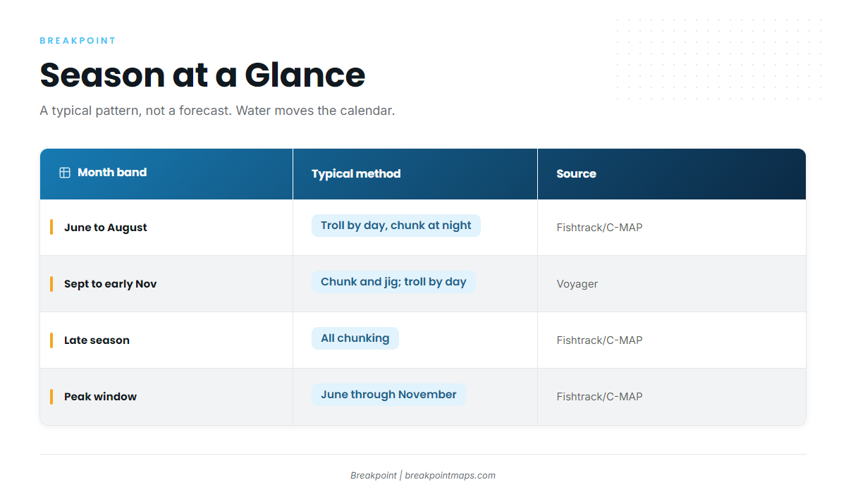
| Month band | Typical method | Source |
|---|---|---|
| June to August | Troll by day, chunk at night | Fishtrack/C-MAP (Lambros) |
| September to early November | Chunking and jigging emphasis; trolling can work in daylight into late afternoon | Voyager (Point Pleasant) |
| Late season | "All chunking" | Fishtrack/C-MAP (Lambros) |
| Overall peak window | June through November | Fishtrack/C-MAP |
A typical pattern, not a forecast. Water moves the calendar.
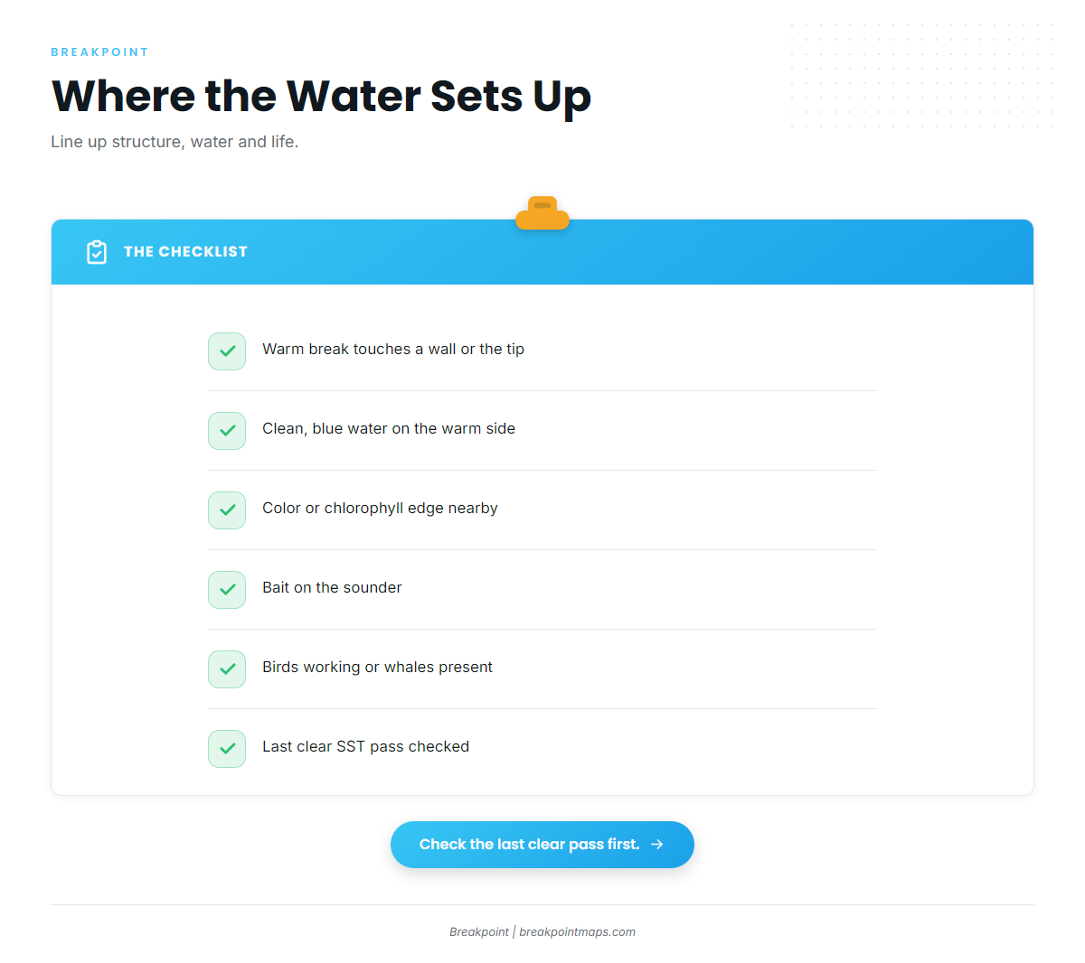
Where the warm water sits matters more than the calendar.
Regional Differences
For the broader picture, start with the Atlantic Northeast guide linked above.
The Hudson is the biggest canyon on this coast and among the closest to the NJ and NY inlets, which is why many crews start here. When the warm water sits elsewhere, the fleet shifts to other canyons. Point Pleasant’s Voyager party boat is an example: it fishes the Hudson, Toms and Lindenkohl during its September to early November tuna season, choosing a canyon by the water.
| Dimension | Hudson | Toms / Lindenkohl |
|---|---|---|
| Size and profile | Largest East Coast canyon, long shelf valley leading in | Smaller canyons farther south along the NJ shelf edge |
| Approximate run | Roughly 75+ mi from central NJ inlets (Fishtrack) | Measure on your own chart |
| Why you’d choose it | Warm edge touching Hudson walls | Warm water sitting south of the Hudson |
Distances approximate. Chart layers and this table are not for navigation.
Spot names such as the Glory Hole, Chicken Canyon and the Tails come up on the radio. Crews also weigh Block and Spencer canyons when the water shifts.
Habitat & Conditions at the Hudson Canyon
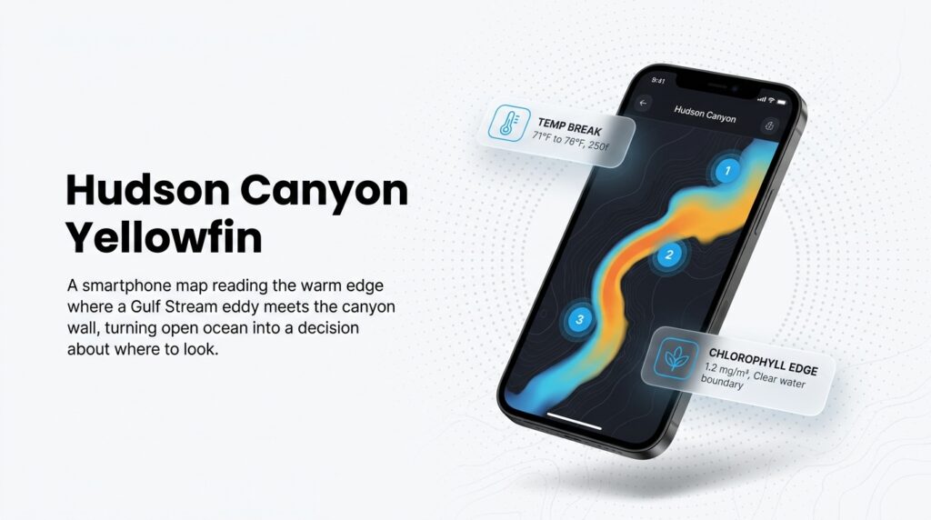
Yellowfin set up at the Hudson Canyon where three things line up. Warm, clean water pushed by a Gulf Stream warm-core eddy has to touch the canyon walls and tip, bait has to be present, and structure has to concentrate both. Any one of these alone is just a place on a chart.
The structure: head, tip and walls
Current meeting a steep wall pushes water and bait upward and concentrates it. That is why a break over the wall beats the same break over 6,000 feet (1,000 fathoms) of open water, where bait has nothing to stack against.
- Head and tip: the landward end, where the canyon notches the shelf and the shelf first breaks away.
- East and west walls: where depth falls fastest and current meets structure.
- Fingers and edges: the folds along the walls that steer current and bait.
The water: eddies and temperature breaks
A warm-core eddy is a ring of Gulf Stream water that drifts onto or near the shelf edge, and its edge forms the temperature break you are looking for.
Asbury Park Press reports show the pattern. One party boat captain searched for warm water and settled where it was 75 degrees. Another crew trolled the clean side of a 77-degree break with skirted ballyhoo.
A workable decision logic:
- The break touches a wall or the tip: start there.
- The break sits well off the canyon: weigh the extra run against another canyon.
- The water is warm but has no edge or color: expect a scattered bite, and search for bait instead.
The data has limits:
- Eddies are ephemeral. They drift and fall apart.
- Cloud cover blocks the SST pass, so the most recent clear image may be days old.
- Surface temperature does not show what is happening at depth.
Water color and chlorophyll
A chlorophyll or color edge can show where bait is gathering before the temperature break sharpens. Plankton-rich shelf water meets clean blue water, and the line between them often holds life. Read SST and chlorophyll charts together.
Life: bait, squid, butterfish, whales, birds
The Mid-Atlantic Fishery Management Council manages the forage these fish eat, including longfin squid, Illex squid and butterfish. It does not manage tuna. Once you arrive, look for whales, working birds and marks on the sounder. Squid rise toward lights at night, which sets up the overnight tactics below.
Tactics for the Hudson Canyon
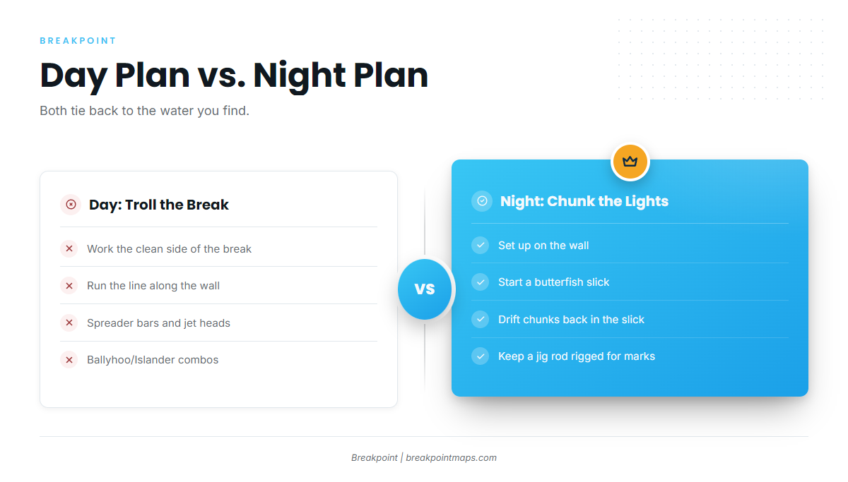
In summer, troll by day and chunk at night. In fall, lean toward chunking and jigging. Every tactic below depends on the water you find, so choose one after you read the break.
Capt. Deane Lambros of Canyon Runner Sport Fishing, who has made more than 500 canyon runs out of Manasquan, describes the seasonal shift this way: "In the summer, we’ll troll during the day and chunk at night. Later on in the winter, it’ll be all chunking all the time."
Day plan: trolling the break
Lambros’s spread draws on a familiar lure list:
- Spreader bars
- Jet heads
- Ballyhoo/Islander combos
- Joe Shutes or sea witches
Work the clean side of the break along the wall, as in the Asbury Park Press example above.
Night plan: chunking and the lights
An On The Water writer fished a 36-hour party boat trip. On that trip the captain anchored on the west wall overnight, and two 60-pound yellowfin came on butterfish chunks. Tuna passed under the boat and showed on the fishfinder, and a jig rod at the ready let anglers drop a lure quickly. The Asbury Park Press likewise reported tuna schooling under a boat at 3 a.m.
A general night sequence:
- Set up on the wall.
- Start a butterfish slick.
- Drift baits back in the slick.
- Keep a jig rod rigged for marks.
Vertical jigging
When fish mark under the boat, drop a jig. On The Water and Voyager both describe the method.
Safety and fuel checklist
Check these before you leave the dock:
- A filed float plan
- A registered EPIRB
- VHF, plus a backup
- A conservative fuel reserve (the thirds rule is a common convention)
- A weather window that covers the ride home
For travelers
Private overnight charters run to several thousand dollars. Party boat berths have run roughly $500 to $600, per On The Water. Confirm current rates with any operator before you book.
FAQ
When is the best time for yellowfin tuna at the Hudson Canyon?
Fishtrack/C-MAP gives the peak window as June through November, and Voyager’s tuna trips run September through early November. Treat both as a pattern. The water decides the calendar, so check where the warm edge sits before you commit.
How far is the run to the Hudson Canyon?
Fishtrack reports runs of 75-plus miles each way from central New Jersey, and Coastal Fishing puts it about 100 miles southeast of Sandy Hook. Both are approximate. Measure on your own chart, and remember chart layers are not for navigation.
Should I troll or chunk?
In summer, Capt. Deane Lambros trolls by day and chunks at night. Late in the season he says it is all chunking. Let the water guide you: troll a clean break along a wall, and chunk when you hold on the structure after dark.
Which permit do I need?
Private boats need an HMS Angling permit, and for-hire boats need a Charter/Headboat permit. Also check the NJ and NY saltwater registries. Verify all of it with NOAA Fisheries HMS.
Does the proposed sanctuary change fishing?
NOAA started the designation process in June 2022. Draft designation documents, a public comment period and a final decision come later. Check the NOAA Office of National Marine Sanctuaries page.
Before You Commit the Fuel
Structure, water and life all have to line up on the walls. Before you commit the fuel, we’d pull up OBS SST and Chlorophyll over the Hudson on the last clear pass, lay Chart Contours on top, and see whether the warm edge is actually touching the walls. That is what Breakpoint is for.
Chart layers are not for navigation.