


This guide covers bigeye tuna (Thunnus obesus), a deep-living Atlantic tuna found along the shelf edge and canyons from the Northeast to Hatteras. In the Mid-Atlantic canyons the season runs roughly July through October. It is a low-odds, high-effort fishery that rewards precision over volume.
Introduction
If you already run to the canyons for yellowfin and mahi, the question is whether bigeye justify the fuel and the long days.
According to FishTalk’s bigeye primer, many anglers go seasons on end without a hookup, and a hookup doesn’t guarantee a fish at the boat, because the soft "paper" mouth lets hooks pull. Capt. Randy Butler runs 18-hour trips built around the dawn and dusk bites, which gives a sense of the time cost.
This page covers identification, habitat, a starting tactic, gear and the federal rules. Canyon-by-canyon detail is on the regional pages. We think bigeye are worth targeting if you accept the odds and plan around water conditions. We also know how much we don’t know: much of a bigeye’s life happens far below where anglers or sensors can see.
Overview
Bigeye tuna (Thunnus obesus) are a large, deep-feeding Atlantic tuna that NOAA Fisheries manages as a highly migratory species. According to NOAA’s Atlantic bigeye species page, they reach about 5.5 feet in length, live up to 9 years and can reproduce at about 3.5 years. They feed near the top of the food chain on fish, crustaceans and squid.
Canyon anglers describe fish that regularly push past 200 pounds and fight straight down. Bigeye are also one of the BAYS tunas (bigeye, albacore, yellowfin, skipjack), a grouping that matters when you read the rules.
How to tell bigeye from yellowfin
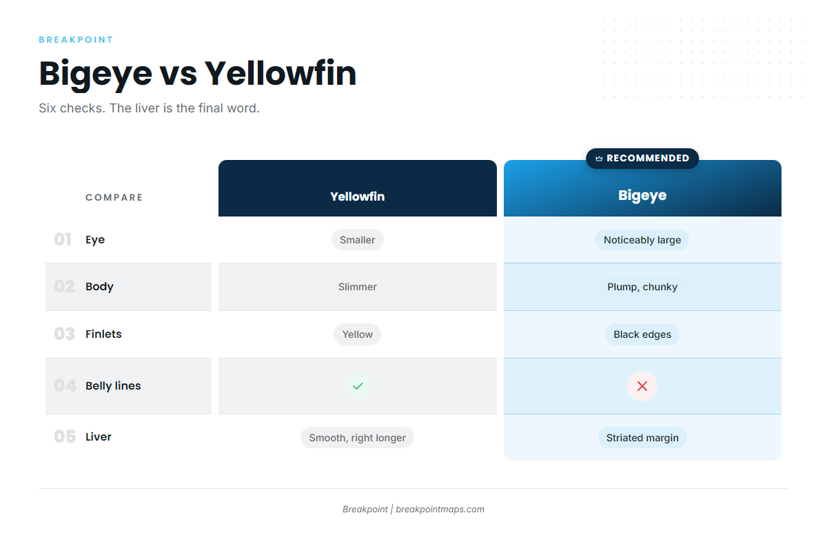
The two fish look alike and are hard to separate without experience, and a wrong ID undermines your records and catch reporting. This table compares them:
| Feature | Bigeye | Yellowfin |
|---|---|---|
| Eye | Noticeably large | Smaller |
| Body depth | Plump, chunky head | Considerably slimmer |
| 2nd dorsal and anal fins | Do not reach back as far | Reach further back on large fish |
| Finlets | Black edges | Yellow |
| Belly | No alternating pattern | Alternating light lines and dots |
| Liver | Striated margin, right and left lobes about equal | Smooth, right lobe clearly longer |
Eye, finlet and body-shape cues come from NOAA. The belly pattern, fin length and liver details come from the IGFA Atlantic tuna ID guide.
External cues help, but the striated liver is the definitive check. FishTalk adds that iridescent blue bands along the sides can show on bigeye but fade fast, so check them the moment the fish leaves the water. Juveniles are especially difficult to identify.
How bigeye behave
Bigeye run deep by day and rise at night, following squid. According to Luresnline, they hold around 400 to 500 ft by day and come up to about 100 ft after dark. Other sources put daytime canyon-edge depths at 1,500 ft or more, with recorded dives beyond 1,800 ft.
Daytime depths vary, so treat every figure as a range. The day and night depth ranges are a starting point.
Bryan Fromm of the f/v Flying Dutchman calls bigeye the most structure-oriented tuna in the ocean. The feeding windows are dawn and dusk, and fog and low light also produce. Because the fish move up and down with the light, every tactic below changes with it.
Habitat & Range
In the US Atlantic, bigeye are found along the continental shelf edge and its canyons, where steep contours meet warm blue water.
Structure comes first. Capt. Randy Butler’s canyon tactics start with a sharp drop-off, and he works the 100-fathom line (about 600 ft). InTheBite notes that tight contour lines on bathymetric charts mean steep structure. Chart layers are for planning, not navigation.
Then look at the water:
- Surface temperature: The Tackle Room puts it above 70°F, with cooler water below.
- Temperature breaks: Fish gather on the edges where warm and cool water meet, especially on the northwest sides where current pushes bait against structure.
- Pilot whales: They share the squid diet and can signal bigeye on canyon edges, though they don’t guarantee fish.
Some summers never bring blue water over the canyons, and Capt. Butler notes those summers are slow. Season-to-season variation is real and outside anyone’s control.
Northeast and Mid-Atlantic canyons
The canyon chain runs from Georges Bank at the northern end down through Hudson, Baltimore, Washington and Norfolk canyons. The Tackle Room lists Hudson Canyon, the Tails, the Dip and the 100 Square as productive spots. Per InTheBite, canyon corners and east notches hold fish year after year.
Fromm finds bigeye in water from 100 to 1,000-plus fathoms (about 600 to 6,000-plus ft of water). He calls 150 to 350 fathoms (about 900 to 2,100 ft) the sweet spot and notes that yellowfin are rarely caught in water deeper than 200 fathoms. These figures describe the water depth where fish are found, not how deep the fish swim. The eight bigeye elements from Bryan Fromm go further on structure.
For canyon-specific timing and patterns, see our guide to bigeye tuna fishing in the Atlantic Northeast.
Hatteras and the Southeast
According to Luresnline, bigeye move up the coast from the Carolinas in late June as water passes 70°F. Hatteras and the Blake Plateau are part of the range, with the Gulf Stream edge as the main feature. For that end of the range, see bigeye tuna fishing in the Atlantic Southeast.
If you’ve fished bigeye elsewhere: the pattern here is structure-first, the fishery depends on blue water, and US federal permits apply.
Season and conditions for bigeye tuna fishing
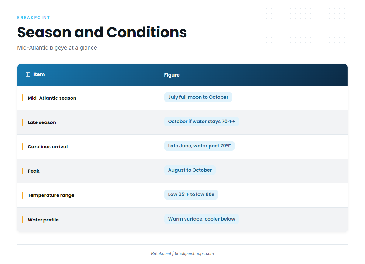
| Item | Figure | Source |
|---|---|---|
| Mid-Atlantic season | First full moon in July through October | Capt. Butler, Saltwater Sportsman |
| Late season | Into October if water stays over 70°F | Capt. Butler |
| Arrival from Carolinas | Late June, as water passes 70°F | Luresnline |
| Peak | August through October | Luresnline |
| Temperature range | Low 65°F to low 80s | Luresnline |
| Water profile | Warm surface over 70°F, cooler below | The Tackle Room |
Tactics
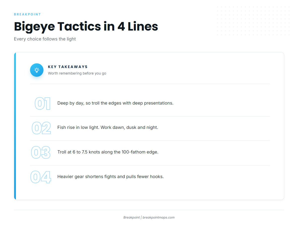
Fish that hold deep by day call for deep presentations along the edges, and fish that rise in low light call for dawn, dusk and night windows. There is no fixed procedure, only a starting logic. Saltwater Euphoria calls it a precision game rather than a numbers game and gives a trolling speed of 6 to 7.5 knots.
Daytime trolling
Capt. Butler’s spread, as reported by Saltwater Sportsman:
- Sea Stars close in, off the short rigger.
- Ilanders off a short rigger and one flat line.
- Sea Witches over horse ballyhoo on the long and center riggers.
Spreader bars and daisy chains are the classic teasing element. Deep-diving plugs in canyon spreads, such as the Shimano Ledge Runner, have become staples. We’d start where a temperature break crosses steep contour along the 100-fathom edge.
Low light and night
Dawn and dusk are the prime windows, and Capt. Butler’s 18-hour days are built around them. The Tackle Room recommends darker nights, reasoning that the bigeye’s low-light vision is an advantage then.
Night chunking is a canyon option.
Deep jigging
Daylight jigging follows from the fish holding deep. InTheBite says 99% of bigeye are caught on rod and reel in 100 to 400 fathoms (about 600 to 2,400 ft of water).
Tackle
Two setups show how far apart gear choices can be:
- Butler setup: International 130s, a 25 ft top shot of 200 lb mono, an 8 ft 200 lb fluorocarbon leader and an 11/0 hook. He beat a 305 lb fish in 12 minutes.
- Retail setup: 50 to 100 lb class stand-up rods, 5’6" to 6′, two-speed lever drag reels, 65 to 80 lb braid and a 25 ft 200 lb mono top shot. This is the lighter stand-up tackle setup from The Tackle Room.
Heavier gear shortens fights and reduces pulled hooks. Shorter fights are also easier on the fish and the crew.
The fight
Bigeye fight straight down, and fights can run long. Saltwater Sportsman describes an hour-long battle. The paper mouth calls for steady, consistent pressure. Circle hooks set in the corner of the jaw, so check the HMS circle-hook rules in the Regulations section before you rig.
Handling for the table
FishTalk notes that bigeye flesh is high in fat, which gives it a distinct flavor. Bleed the fish promptly and get it cold fast. For mercury, check FDA or state advisories.
Fishing bigeye in your region
For canyon timing and patterns, go to bigeye tuna fishing in the Atlantic Northeast. For the Gulf Stream and Hatteras, read bigeye tuna fishing in the Atlantic Southeast.
Frequently Asked Questions
How do you tell a bigeye from a yellowfin?
Look for the bigeye’s larger eye, plumper body, shorter second dorsal and anal fins and black-edged finlets. Yellowfin show a belly pattern of light lines and dots that bigeye lack. The definitive check is the striated liver, per NOAA and The Fisherman.
What is the size limit for Atlantic bigeye?
The minimum is 27 inches curved fork length. There is no bag limit for bigeye. Tunas cannot be retained if a hammerhead or oceanic whitetip shark is on board or has been offloaded. Verify before you fish.
Do I need a permit to fish for bigeye?
Private boats need an HMS Angling permit. For-hire vessels need an HMS Charter/Headboat permit. Confirm both with NOAA Fisheries HMS before you go.
When is bigeye season in the Mid-Atlantic?
Capt. Butler puts the season from the first full moon in July through October, longer if water holds above 70°F. Luresnline puts the peak at August through October.
How deep are bigeye during the day vs. at night?
They run deep by day, often 400 ft or more, with reports beyond 1,800 ft. At night they rise to about 100 ft, following squid. Treat these as ranges.
Is bigeye good to eat?
Yes. According to FishTalk, the high fat content gives it a distinct flavor. Bleed and chill the fish quickly.
Closing
The short list for bigeye is structure, blue water, temperature breaks and the right light window. Breakpoint’s hotspots and Fish Intel use sea surface temperature, chlorophyll and depth contours to show where a temperature break crosses the 100-fathom line before you burn the fuel. Clouds can block satellite SST passes, chart layers are not for navigation, and no tool promises fish. What it can give you is a better decision about where to look.