Overview
Mahi-mahi fishing in the Atlantic Northeast is a late-summer fishery. Warm Gulf Stream water brings the fish in, and they leave when it recedes. According to On The Water, mahi fishing out of New York typically opens in early July and can run as late as mid-October, depending on location, with fish reaching as far north as Massachusetts.
For biology, general rigging and the case for chasing the species at all, start with our mahi-mahi species guide. This page covers where, when and how in this region. In the Northeast, mahi depend on conditions and usually come as an add-on to canyon tuna trips. Below we cover where the warm water sits, how to find its edge and the floating structure on it, how to fish it, and what the rules are. The fish here are dolphinfish (Coryphaena hippurus); mahi, dolphin and dorado all name the same animal.
Regional Differences
Mahi in the Northeast are a short, eddy-dependent season fished mostly on long offshore runs, and most anglers catch them as a bonus on tuna trips. Five things set this fishery apart from the Southeast pattern:
- Short season. The On The Water window runs from early July to mid-October. Most reports we’ve read cluster in late summer, but exact timing shifts by year and location.
- Eddy dependence. A Belmar, NJ charter operator (Golden Eagle Fishing) says mahi in the Mid-Atlantic "typically arrive during the late summer and early fall when warm Gulf Stream eddies push closer to the coast." That is one operator’s observation, but it matches what other sources describe.
- Size profile. On The Water reports that the biggest bulls typically travel alone in open water and can reach 90 pounds, while smaller fish congregate on floating structure. In running the bulls offshore, The Fisherman describes a large bull holding below a school of gaffer-class fish on an offshore high-flyer. Expect mostly schoolies and gaffers on structure; bulls are possible but uncommon.
- Long runs. The Belmar operator describes canyon trips of often 16 to 23 hours to reach bigger fish patrolling temperature-break edges.
- A bonus on tuna trips. The Fisherman’s party-boat tuna primer notes that longer canyon trips often leave time to pot-hop for mahi. On The Water describes a New Jersey day that paired yellowfin tuna within 20 miles of the coast with mahi fishing between the lobster pots around Monster Ledge.
Timing and Where
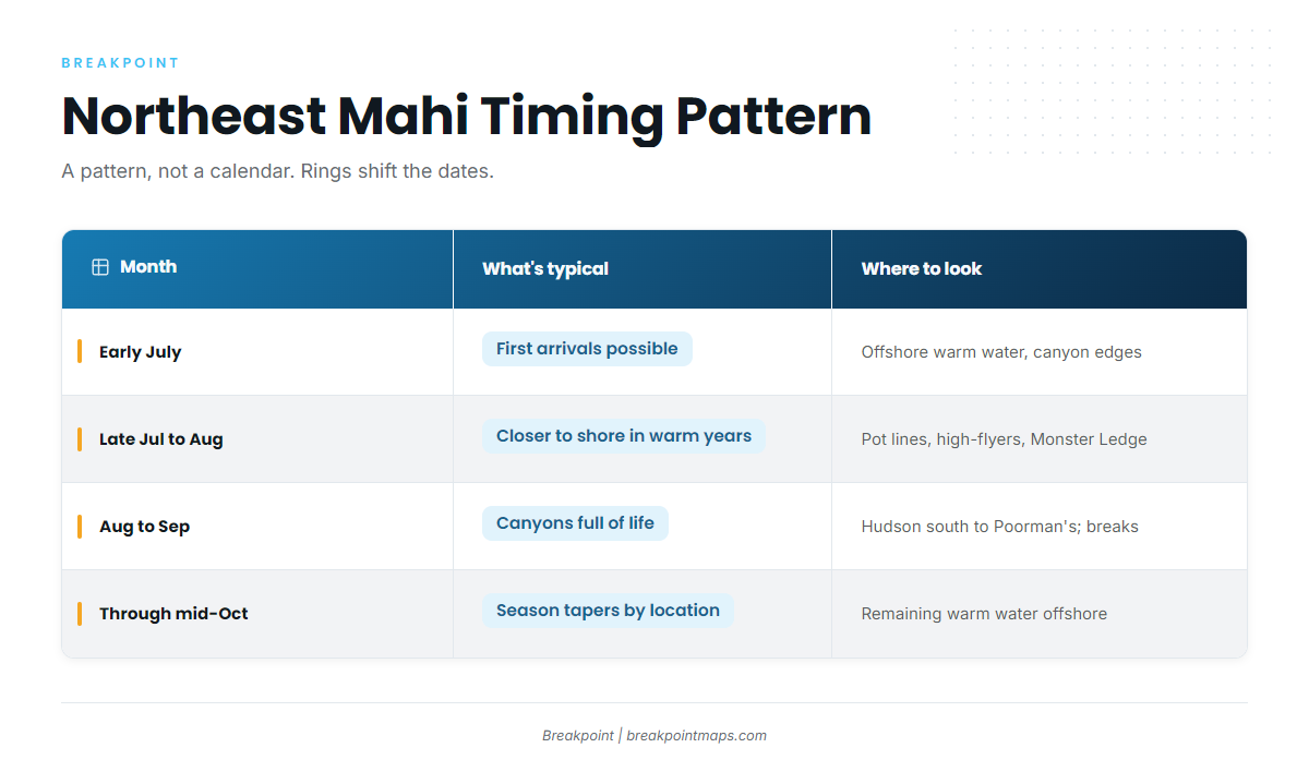
| Month | What’s typical | Where to look |
|---|---|---|
| Early July | First arrivals possible | Offshore warm water, canyon edges |
| Late July to August | Fish reported closer to shore in warm years; juveniles on high-flyers | Pot lines, high-flyers, inshore lumps such as Monster Ledge |
| August to September | Canyons full of life; bigger fish on breaks | Hudson Canyon south to Wilmington and Poorman’s; temperature-break edges |
| Through mid-October | Season tapers, varies by location | Remaining warm water offshore |
Sources for the table: On The Water (season window and Monster Ledge), Sport Fishing Magazine (juveniles on high-flyers), The Fisherman, 2020 (canyons in late summer and fall), and a Cape May charter source (southern canyons). A 2016 angler blog reports inshore fish "usually in August," which is dated and anecdotal. Months shift with where the rings sit, so treat this as a pattern rather than a calendar.
Cape May, Montauk and Point Judith are common departure points.
What to Ask a Captain
- Is the boat running offshore to the canyons, or staying inshore?
- Where is the warm water sitting this week, and is a ring in range?
- Is this a tuna trip with mahi as a bonus, or a mahi-focused day?
Habitat & Conditions in the Atlantic Northeast
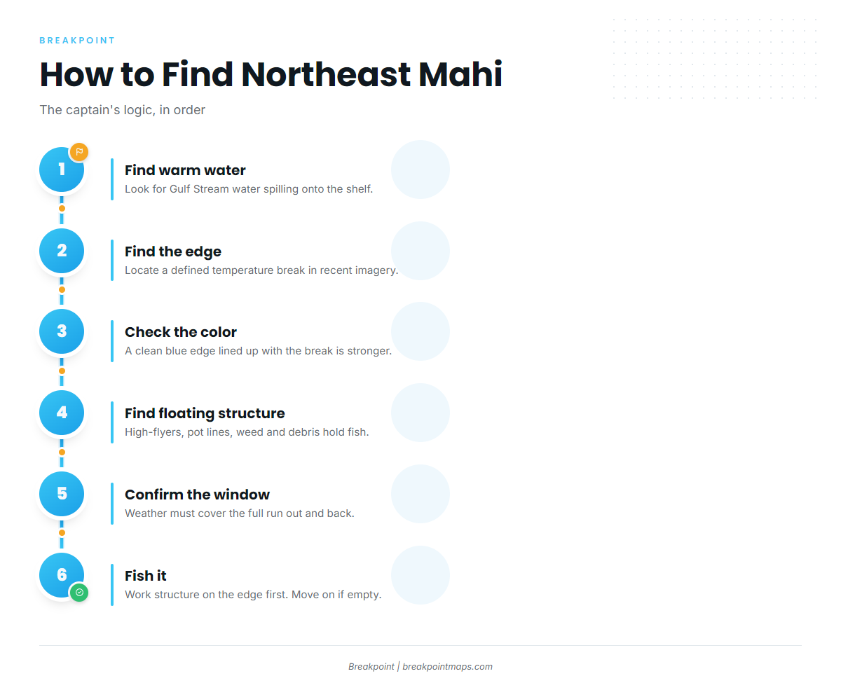
Mahi in the Northeast live where Gulf Stream water spills onto the shelf. The job is to find that water, find its edge, then find something floating on it.
Warm-Core Rings
A warm-core ring is a detached piece of Gulf Stream parked over the shelf, carrying warm, clean water and the fish that live in it. A Cape May charter source says that from June through October, warm Gulf Stream eddies push north and bring pelagic species within range. Sport Fishing Magazine says swaths of warm, clean water can spin off the Gulf Stream and push close to shore in summer.
Temperature Breaks
Treat temperature as a working range rather than a rule. Three data points:
- This Cape May canyon fishing report tells anglers to look for defined breaks where 72-degree inshore water meets 76-degree Gulf Stream water.
- FishTalk Magazine gives general mahi temperature preferences of around 82 degrees, with fish found as low as 68 degrees. That figure is general, not Northeast-specific.
- The edge matters more than any single number.
Late-summer haze and cloud often block satellite SST passes, so a clean shot from two days ago may not reflect today.
Color and Chlorophyll Edges
Clean blue water and a color change mark the edge in a second dimension. Sport Fishing Magazine notes that free NOAA data tracks chlorophyll levels, and the Cape May source adds that smart captains check satellite SST imagery before committing to a destination. A color edge that lines up with a temperature break is a stronger signal than either alone. That is our reasoning, not a sourced statistic.
Floating Structure
In open water, anything floating concentrates bait, and mahi follow the bait. A high-flyer can be the only shade for miles. That is an analogy, not a proven mechanism. The sources agree on what to look for:
- The Belmar operator lists floating debris, lobster pot lines, temperature breaks, weedlines and "even small pieces of driftwood."
- Sport Fishing Magazine explains that high-flyers are tall buoys with radar reflectors that mark lobstermen’s pots, and it reports juvenile mahi on high-flyers.
- The Fisherman describes gaffers on a high-flyer with a bull below.
Sargassum and weedlines count as structure per the Belmar list.
Canyons
From north to south, the canyons anglers name are Veatch, Atlantis and Block in southern New England, Hudson off New York and New Jersey, and Baltimore, Wilmington and Poorman’s at the southern edge. The Cape May source calls Wilmington’s southern wall excellent for yellowfin and mahi, and says Poorman’s often holds mahi and yellowfin. The Fisherman says canyons are full of nutrient-rich water and life in late summer and fall.
Fish the warm water where it sits, whatever the canyon is called.
Conditions Checklist
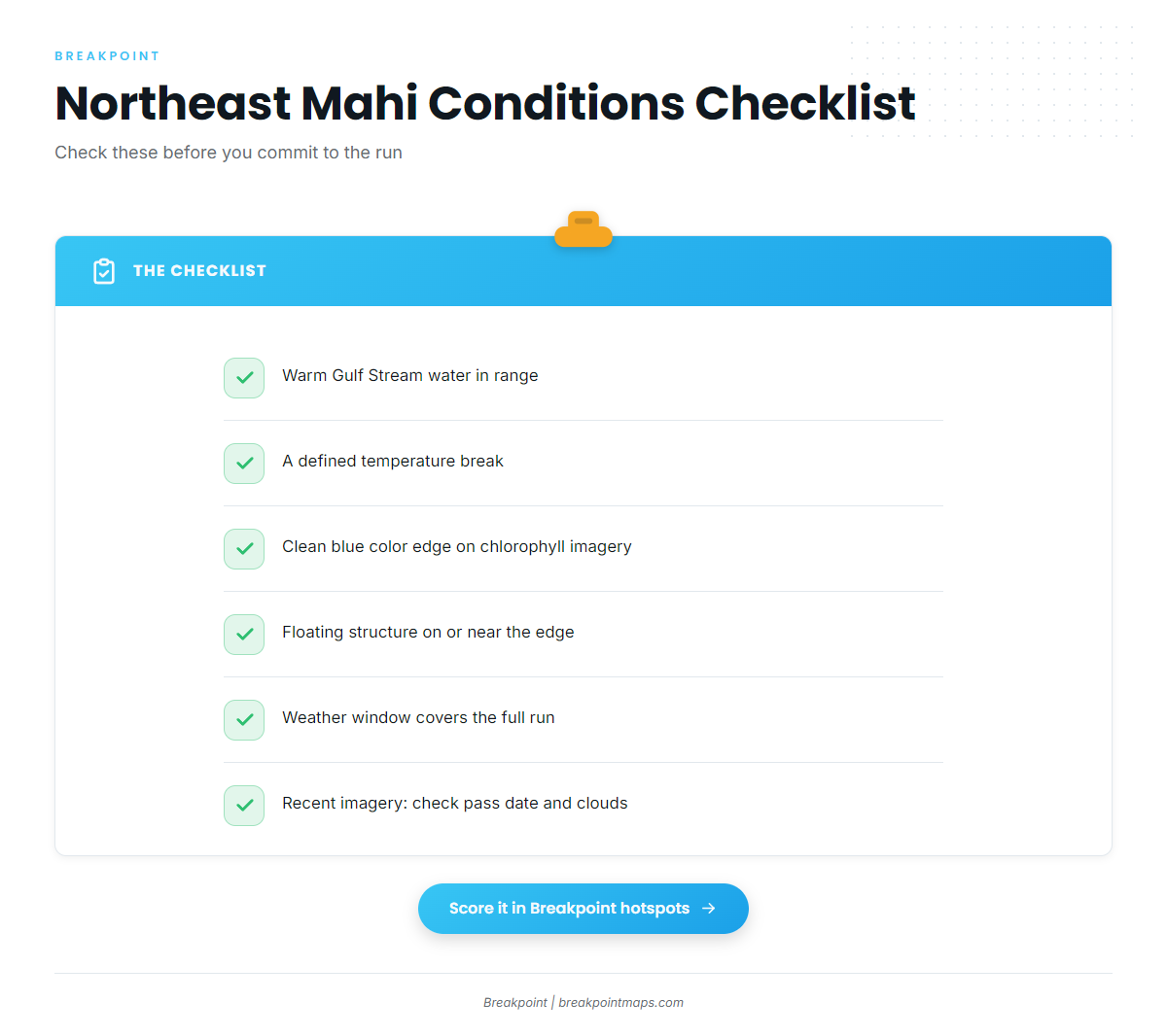
- Warm Gulf Stream water in range, whether a ring or a finger.
- A defined temperature break, using the working range above.
- A clean blue color edge on chlorophyll imagery.
- Floating structure on or near the edge: high-flyers, pot lines, weed, debris.
- A weather window that covers the full run out and back.
- Recent imagery. Check the pass date and cloud cover.
What We Don’t Know
Ring behavior varies year to year. Rings drift and decay, and nobody can promise where one will sit next week. NOAA Fisheries lists the population level and overfishing status of the South Atlantic stock as unknown, with management measures in place (see Regulations below). The sources in this guide are mostly charter and magazine experience, not survey science.
Tactics for the Atlantic Northeast
On most Northeast canyon trips, you fish for mahi while you fish for tuna, so set the spread and the route to cover both. We skip general mahi rigging here; the fundamentals are in the species guide.
Mixed Spreads
FishTrack’s article on fishing the Northeast canyons describes a Mold Craft squid teaser off each rigger and a dredge off the cockpit corner to add appeal behind the boat. It also says larger ballyhoo are effective for bigeye at dusk and dawn. Ballyhoo and feathers are common trolling baits for both tuna and mahi.
Running Structure
The Fisherman’s party-boat primer notes that longer canyon trips often leave time to pot-hop in search of mahi. Sensible pot-hopping follows the conditions checklist:
- Work structure that sits on the edge first.
- Pass each high-flyer close.
- Move on if nothing shows.
Fewer, better-placed stops beat a long chain of random ones.
Holding a School
The Fisherman’s primer describes tuna anglers tossing a steady stream of butterfish chunks and drifting hooked baits in it. Applying that to mahi is common practice, though not sourced mahi data. The idea is to keep baits in the water to hold a school near the boat, and to pitch baits to any fish that follow a hooked one to the boat.
When Warm Water Comes Close: Nearshore Light Tackle
This applies to warm years only and depends entirely on conditions. On The Water describes mahi between the lobster pots around Monster Ledge, and notes they can be caught on light inshore tackle, so spinning gear is a reasonable starting point. A 2016 angler blog reported mahi south of Martha’s Vineyard "as close as 5 miles" and small fish off Central New Jersey jetties when blue water reached the beach. Both are dated, anecdotal reports.
Watch weather and sea state, and file a float plan. We discourage offshore kayak attempts, because the conditions that bring blue water close can change fast. Chart layers are not for navigation.
Conclusion
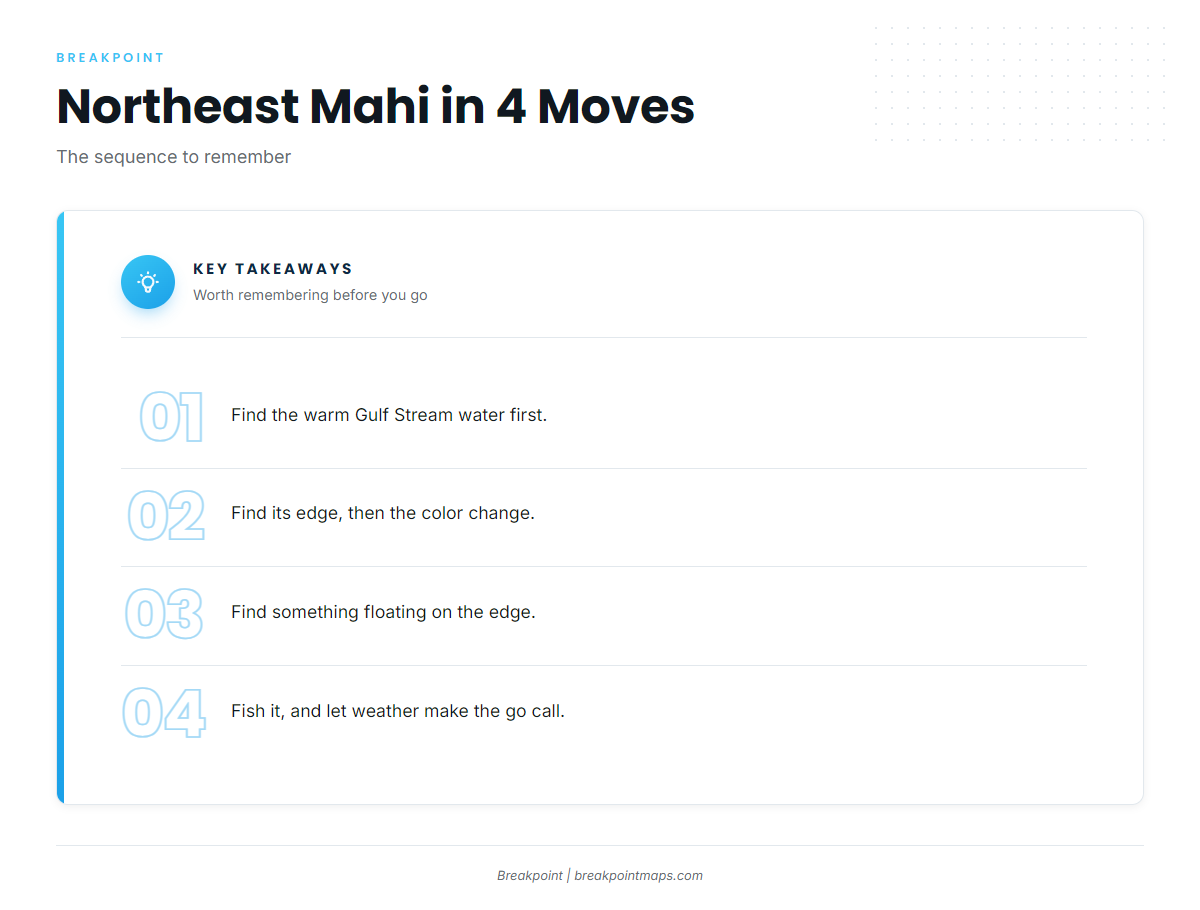
The sequence is the same every trip: warm water, then the edge, then floating structure, then fish it. Northeast mahi season favors anglers who check the ocean before leaving the dock. Breakpoint’s hotspots feature scores mahi-mahi in the Atlantic Northeast by combining sea-surface temperature, chlorophyll and structure signals, which helps you decide where to look. Cloud cover blocks satellite passes, and a score is a decision aid, not a promise of fish. On a long run, the weather window makes the go or no-go call.
Frequently Asked Questions
When is mahi season in the Northeast?
According to On The Water, fish typically arrive in early July and leave as late as mid-October, depending on location. Timing follows where warm Gulf Stream water sits in a given year, so it shifts year to year.
How far offshore do you need to go?
It depends on where the warm water sits. Canyon trips often run 16 to 23 hours, per the Belmar charter operator. In warm years, On The Water describes fish on inshore pot lines around Monster Ledge.
Can you catch mahi from shore in New Jersey?
Rarely. A 2016 angler blog reported small mahi hooked at the end of a Central New Jersey jetty when warm blue water pushed all the way to the beach. It is an anecdotal report, and shore fishing is not a realistic plan for mahi.
Where do I check dolphin bag limits?
For federal waters, check NOAA Fisheries and the South Atlantic Fishery Management Council. For state waters and registries, check NJDEP, NYSDEC and RI DEM.