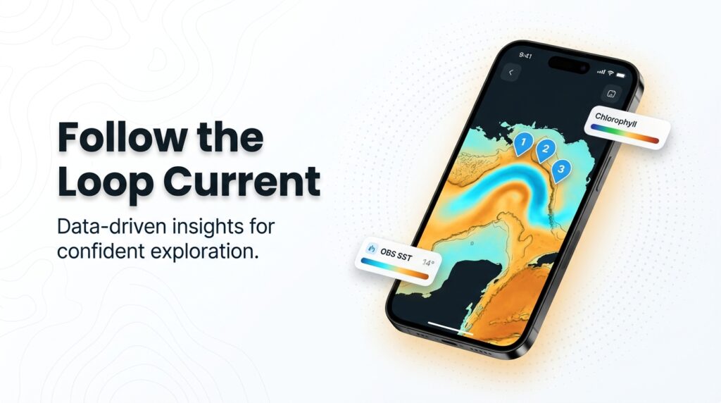
Blue marlin fishing in the Gulf of Mexico runs on the Loop Current. Warm water enters through the Yucatán Channel, sheds eddies northward, and pushes blue water toward the canyons and deepwater platforms. Boats make long runs to those edges, then troll lures or live bait around rigs.
For the fundamentals (biology, tackle classes, how a bite unfolds), start with our blue marlin species guide. This page covers only what changes in the Gulf.
A naming note: U.S. government pages, including NOAA, now label these waters the Gulf of America. Search both names when you look up rules.
The sections below cover where the water sets up, how Gulf crews fish it, and the rules that apply. We read the oceanography and the regulations, and we cite the captains who fish it. We make no claims about our own catches.
Regional Differences
Five things set the Gulf apart from other blue marlin water. The first is the Loop Current.
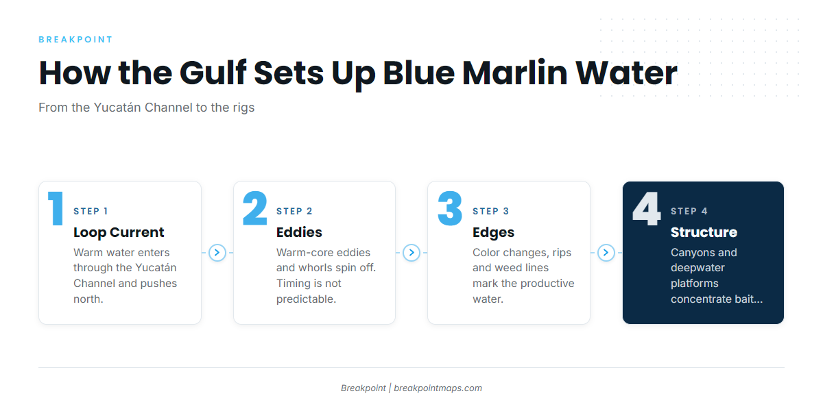
The Loop Current. According to Thomas Hilton of Hilton’s Realtime Navigator, as reported by Great Days Outdoors, the Loop Current’s path through the Gulf starts at the Straits of Yucatan and hits the continental shelf just east of the Mississippi Delta. It curls east past Destin, then turns south about 100 miles off Florida’s Big Bend. Its path is not fixed, and the Gulf does not repeat itself year to year.
Eddies and whorls. The Loop Current sheds warm-core eddies and smaller whorls and filaments. Per Hilton, unnamed whorls and sub-loops are often productive, defined by color changes, rips, and weed lines. Nobody reliably predicts when an eddy will shed, so we give no frequency.
Season. Northern Gulf crews fish hardest from roughly May through September, the tournament season. One captain told Salt Water Sportsman it is "possible to raise a blue marlin any month of the year here in the Gulf." Treat that as a window reported by a publication and a captain, not an established fact. Marlin Magazine describes the Gulf Coast Triple Crown circuit and tournaments that run as three-day long-weekend events, which lets boats make the long runs and stay offshore.
Size. Marlin Magazine reports 300- to 500-pound fish off Orange Beach, and a 1,145-pound blue marlin aboard Best Trait that set an Alabama and Gulf record. Newsweek reported a blue marlin over 1,000 pounds, 145 inches long, about 160 miles southeast of New Orleans. Records are records, not expectations.
Rigs and live bait. Deepwater platforms concentrate bait. Hilton, as cited by Great Days Outdoors, puts fish densities at "20 to 50 times higher around the platforms and FADs than in open Gulf waters." That is a reported figure, and we have no study to point you to. SORD, a tackle maker, calls the Gulf the "live bait blue marlin capital of the world," which is a manufacturer’s claim.
Because most of this fishing happens far from the dock, the table below summarizes what each feature means for planning.
| Regional feature | What it means for you |
|---|---|
| Loop Current and eddies | Blue water and bait move year to year. Plan around current position, not the calendar alone |
| Deepwater platforms | Structure that holds bait far from shore |
| Tournament season, roughly May to September | Most reporting and boat traffic clusters here |
| Long runs | Fuel, trip length, and weather matter more than in many regions |
Habitat & Conditions in the Gulf of Mexico
The chain runs from Loop Current to eddies to edges to structure. Marlin follow bait, bait follows edges, and edges matter most where they cross canyon walls or rigs.
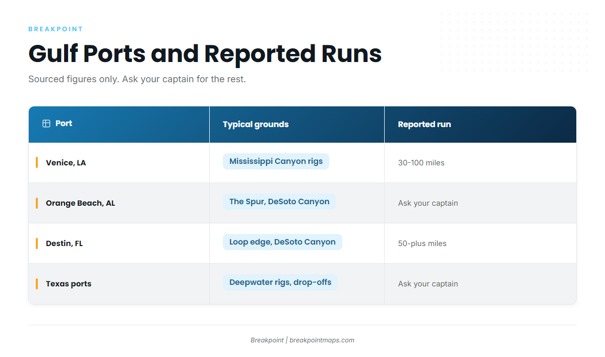
Use this table to plan a port.
| Port | Typical grounds | Reported run distance | Trip length | Season notes | Source |
|---|---|---|---|---|---|
| Venice, LA | Mississippi Canyon rigs | Venice run of 30–100 miles | Not sourced, ask your captain | May to July reported best | One Venice charter operator |
| Orange Beach, AL | The Spur, DeSoto Canyon, rigs | Not sourced, ask your captain | Not sourced, ask your captain | Summer tournament season | Marlin Magazine |
| Destin, FL | Loop Current water, DeSoto Canyon edge | 50-plus miles | Not sourced, ask your captain | Not sourced, ask your captain | A reel maker’s trip planner |
| Port O’Connor, Port Aransas, South Padre, TX | Deepwater rigs and drop-offs | Not sourced, ask your captain | Not sourced, ask your captain | Tournament season | Marlin Magazine |
Swipe the table sideways to see every column.
On trip length, one charter listing describes an 18-hour rig trip near 100 miles out, with about 3 hours each way and roughly 6 hours of fishing. That is a single listing, not a regional norm. A separate reel-maker planner recommends at least a 24-hour trip to target blue marlin.
Texas: Port O’Connor, Port Aransas, South Padre
Marlin Magazine describes 3,360 miles of Texas coastline, running from the Louisiana border past Freeport, Port O’Connor, and Port Aransas to South Padre. The grounds are deepwater rigs and drop-offs, plus Loop Current or eddy edges when they reach the western Gulf.
Louisiana: Venice and the Mississippi Canyon Rigs
One Venice charter operator reports runs of 30 to 100 miles, with May to July as the best window. Mississippi Canyon deepwater platforms are the structure. The Newsweek fish came from about 160 miles southeast of New Orleans, which shows how far the right water can be.
Capt. Jason Buck of Done Deal, out of Houma, is one of the captains Salt Water Sportsman quotes on rig tactics, covered in the next section.
Structure is changing. Platforms are being decommissioned or converted under artificial reef programs such as those run by Louisiana Department of Wildlife and Fisheries (LDWF) and Texas Parks and Wildlife Department (TPWD), overseen federally by the Bureau of Safety and Environmental Enforcement (BSEE) and the Bureau of Ocean Energy Management (BOEM). We give no count. Check current structure before you commit to a run. Chart layers are not for navigation.
Mississippi and Alabama: Orange Beach, the Spur, DeSoto Canyon
Capt. Mike Rowell of Annie Girl, out of Zeke’s Landing in Orange Beach, is another captain quoted by Salt Water Sportsman. Marlin Magazine calls the Mississippi Gulf Coast Billfish Classic the centerpiece of the Mississippi fishery.
The Spur and DeSoto Canyon are the named grounds here, where eddy edges cross steep bottom. Use Chart Contours to see where an edge crosses the canyon walls.
Florida Panhandle and West Coast: Destin to the Big Bend
According to one reel maker’s trip planner, Destin requires a run of 50-plus miles into blue water. The Loop Current curls east past Destin and turns south about 100 miles off the Big Bend, per Hilton.
The Florida west coast shows the value of watching water over days. In Marlin Magazine, a captain said that in the last series of tournaments they fished "the same water moved 8 miles north over 10 days." Good water can persist over structure, and tracking it beats a single pass.
Marlin Magazine’s west coast reporting also cites late July to early October as the strongest window for big billfish and tunas off Florida’s west coast.
Florida Keys, Dry Tortugas, and Isla Mujeres
The Loop Current enters through the Yucatán, so Isla Mujeres and Cancún sit near its source. Ask your charter.
Reading the Signals
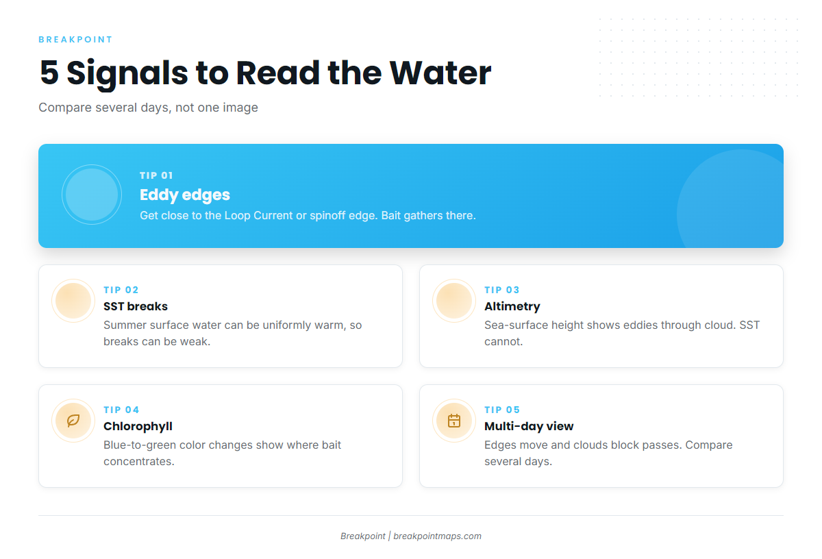
Check these signals before you pick a direction.
- Eddy edges. Captains try to get as close as possible to the Loop Current or its spinoff eddies, per Marlin Magazine. The edge is where bait gathers.
- SST breaks. In summer, Gulf surface water can be uniformly warm, so temperature breaks may be weak. That is one reason altimetry matters.
- Altimetry. Sea-surface height shows eddies through cloud, which SST cannot.
- Chlorophyll. Chlorophyll edges mark blue-to-green color changes where bait concentrates.
- Color changes, rips, and weed lines. Per Hilton, these define the productive whorls. Salt Water Sportsman reports captains slow-trolling live bait when they see marlin feeding along a weed line or near a rig.
- Why one day’s image misleads. A cloud-blocked pass hides the water, and edges move. Compare several days, as the west coast quote shows. A forecast is a forecast.
Tactics for the Gulf of Mexico
Spread basics are in our blue marlin species guide. This section covers how crews in the Gulf adapt them to long runs and rigs. Every tactic below belongs to the captains and publications we name.
Troll to find the water. Many captains start with artificial lures at faster speeds to cover ground and locate eddies, rips, and boundary currents, per Marlin Magazine. Salt Water Sportsman describes 50-pound-class outfits in a typical four-rod outrigger spread. In the Salt Water Sportsman’s Gulf captains profiles, one runs a tight, short spread close to the boat so he can spot fish easily.
Live bait at rigs and weed lines. When a captain sees marlin feeding along a weed line or near a rig, per Salt Water Sportsman, they slow-troll a blackfin tuna or small dolphin. The live baits are bridled through the eyes with dental floss and 12/0 to 16/0 circle hooks. SORD, a tackle maker, argues that tuna tubes are behind most tournament-winning Gulf blue marlin. Weigh that as a manufacturer’s view.
Expect other species. Charters report yellowfin tuna, blackfin tuna, wahoo, and mahi on the same trips. Marlin Magazine notes white marlin and swordfish at 60 to 90 miles out.
Night fishing. Some crews fish rigs overnight.
Circle hooks are also a regulation, so read the next section before you rig.
Frequently Asked Questions
When is the best time for blue marlin fishing in the Gulf of Mexico?
Captains and Marlin Magazine report a roughly May to September tournament window. Salt Water Sportsman quotes a captain who says marlin can be raised any month of the year. Ask your captain what the water is doing now.
What is the minimum size for keeping a blue marlin?
The federal minimum is 99 inches lower jaw fork length. Confirm it on the NOAA Fisheries Atlantic HMS page before you fish, since rules change.
Which permit do I need?
You need an HMS Angling permit in federal waters, or an HMS Charter/Headboat permit on a charter. Tournaments have their own registration. Confirm current permit names with NOAA Fisheries Atlantic HMS.
Does my charter’s permit cover me?
Usually, on a permitted charter. Confirm with the captain and with NOAA Fisheries Atlantic HMS rather than assuming.
What rules apply in Isla Mujeres?
Mexican rules apply. Confirm sportfishing licensing and any billfish release requirements with your charter and CONAPESCA. We print no specifics.
Conclusion
Follow the Loop Current and its eddies, watch the water over several days rather than one pass, fish the edges where they cross canyons and rigs, and keep the rules current. That is the core of blue marlin fishing in the Gulf of Mexico.
Eddies shed on their own schedule, and no chart, ours included, guarantees a bite.
Breakpoint’s hotspots feature scores blue marlin in the Gulf of Mexico by weighing inputs such as OBS SST breaks, Chlorophyll, current edges, and Chart Contours. It cannot see through a cloud-blocked pass, and a forecast is a forecast. It will not promise fish, but it can help you decide where to look.
Chart layers are not for navigation.