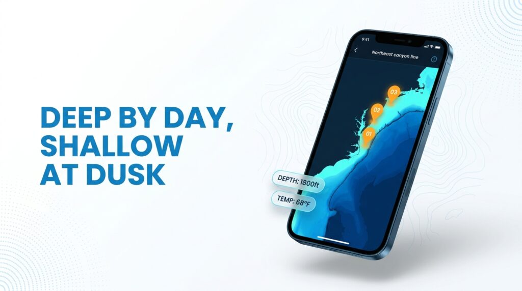
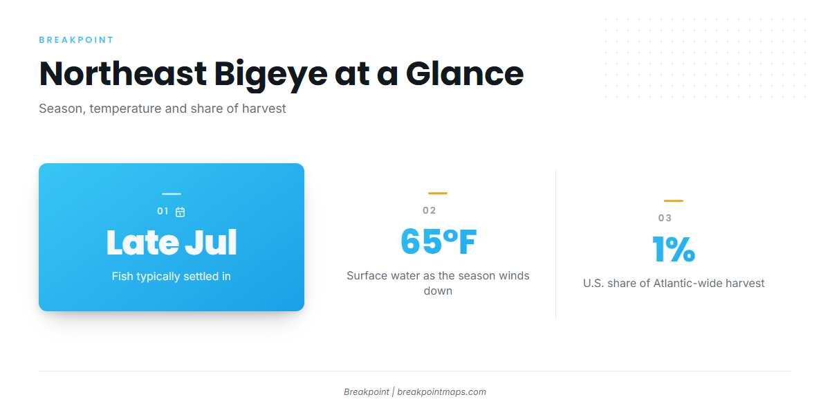
Bigeye tuna fishing in the Atlantic Northeast happens along the offshore canyon line from Hudson to Hydrographer. Fish typically settle in by late July and hold until surface water drops below about 65°F. They fish deep by day and come shallow at dawn, dusk and night.
Overview
For the fundamentals (biology, range, general tackle), start with our bigeye tuna species guide. This page covers only what changes in Northeast water.
The region means the shelf-edge canyons: Hudson, Block, Atlantis, Veatch and Hydrographer. It includes named local grounds like the Dip and the Tails, and stretches toward the Gulf of Maine margins and Georges Bank. Most anglers reach these grounds from Manasquan, Cape May, Montauk or Point Judith, but the canyons matter more than the ports.
In short: fish deep by day, work the edges of light, and expect to run far offshore.
The season window. According to On The Water, bigeye move up the coast from the Carolinas starting in late June. By late July they are settled from Hudson Canyon to the Hague Line, and they hold there until water temperatures drop below 65°F in late fall.
On stock status, NOAA’s Atlantic bigeye status page says the 2021 assessment found Atlantic bigeye overfished but not subject to overfishing. U.S. landings make up only about 1% of the Atlantic-wide harvest.
If you are booking rather than running your own boat, charter formats include long day trips and overnight "canyon" trips. Overnights put you on the water for dusk, night and dawn, when bigeye rise toward the surface.
Regional Differences
Bigeye here behave differently from bigeye in southern water. Five things stand out.
A shorter window. The season is compressed into summer and fall. Plan around the late July to late fall stretch, and treat the edges as uncertain.
Distance. A Northeast canyon trip is a major excursion. Sport Fishing’s night trolling advice describes it as roughly 100 miles out for 24 to 48 hours. A Cape Cod angler’s account of a July 2018 trip out of Osterville describes a 100-plus mile run to the area just west of West Atlantis Canyon, and notes the trip demands careful planning, substantial fuel reserves and a favorable weather window.
The yellowfin mix. Yellowfin rarely go deeper than 200 fathoms (1,200 feet). Bigeye extend well deeper. The same troll can produce both, which matters for identification and reporting (see Regulations).
Canyon walls and the daily depth cycle. The deep-by-day, shallow-at-night pattern covered in the species guide plays out against steep canyon walls here. According to On The Water, bigeye feed on the Deep Scattering Layer, a band of squid and small bait that rises at night and sinks by day. The fish follow it.
Forage and group size. Squid come first; tackle retailer Luresnline also names tinker mackerel. According to On The Water, bigeye typically travel in small groups of 3 to 5 fish, so multiple hookups are common. Plan crew roles before the first bite.
| Difference | What it means in the Northeast |
|---|---|
| Season | Compressed into summer and fall |
| Run | About 100 miles out, 24 to 48 hours |
| Bycatch mix | Yellowfin often on the same troll |
| Fish behavior | Deep by day, rising with the Deep Scattering Layer at night |
| Group size | Small groups of 3 to 5 |
Habitat & Conditions in the Atlantic Northeast
About 95% of rod-and-reel bigeye are caught in 100 to 400 fathoms (600 to 2,400 feet), according to On The Water’s canyon depth breakdown. The sweet spot is usually 150 to 350 fathoms.
Depth: Where Sources Agree and Disagree
The published ranges differ:
- The Fisherman puts the preferred range at 100 to 250 fathoms along the shelf edge.
- On The Water puts it at 150 to 350 fathoms.
- Fish are rarely found shallower than 100 fathoms.
- Daytime fish can sit at 1,500 feet or deeper along canyon edges.
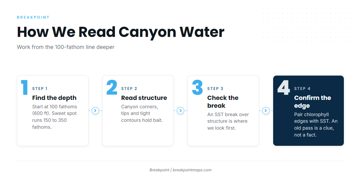
The ranges overlap. Start at the 100-fathom line and work deeper.
Structure
According to On The Water, target canyon corners, east notches where the walls meet the shelf, and canyon tips. Use detailed bathymetric charts on your plotter. Tight contour lines mean steep drops, and steep drops hold bait. Ridges and plateaus are secondary structure worth marking.
Surface Signs
Read temperature breaks and structure together; a break is most useful where it overlaps structure.
Pilot whales are a named indicator. The Tackle Room, a tackle retailer, lists them as a top sign, as does Capt. Randy Butler, whose notes come from Mid-Atlantic water (Virginia), not the Northeast.
A clean SST break over tight contours on the north or east wall is where we would look first. Cloud cover can hide that break for days, so an old pass is a clue, not a fact.
Wind
Capt. Randy Butler’s Mid-Atlantic notes report that the best bite seems to come on a hard northeast wind. His words: "It’s rough as hell, but they like it." The Tackle Room offers a reason: a hard northeast wind pushes warm water against canyon walls and concentrates bait. A northeast blow is also a good reason to stay home, so weigh the bite against the boat.
Warm-Core Eddies
Warm-core eddies and Gulf Stream rings can push warm water toward the canyon edge, so they are worth watching.
Canyon Names
Grounds you will hear named: Hudson, Block, Atlantis, Veatch, Hydrographer, the Dip and the Tails. The Tackle Room names Hudson Canyon, the Tails, the Dip and the 100 Square as productive grounds.
Tactics for the Atlantic Northeast
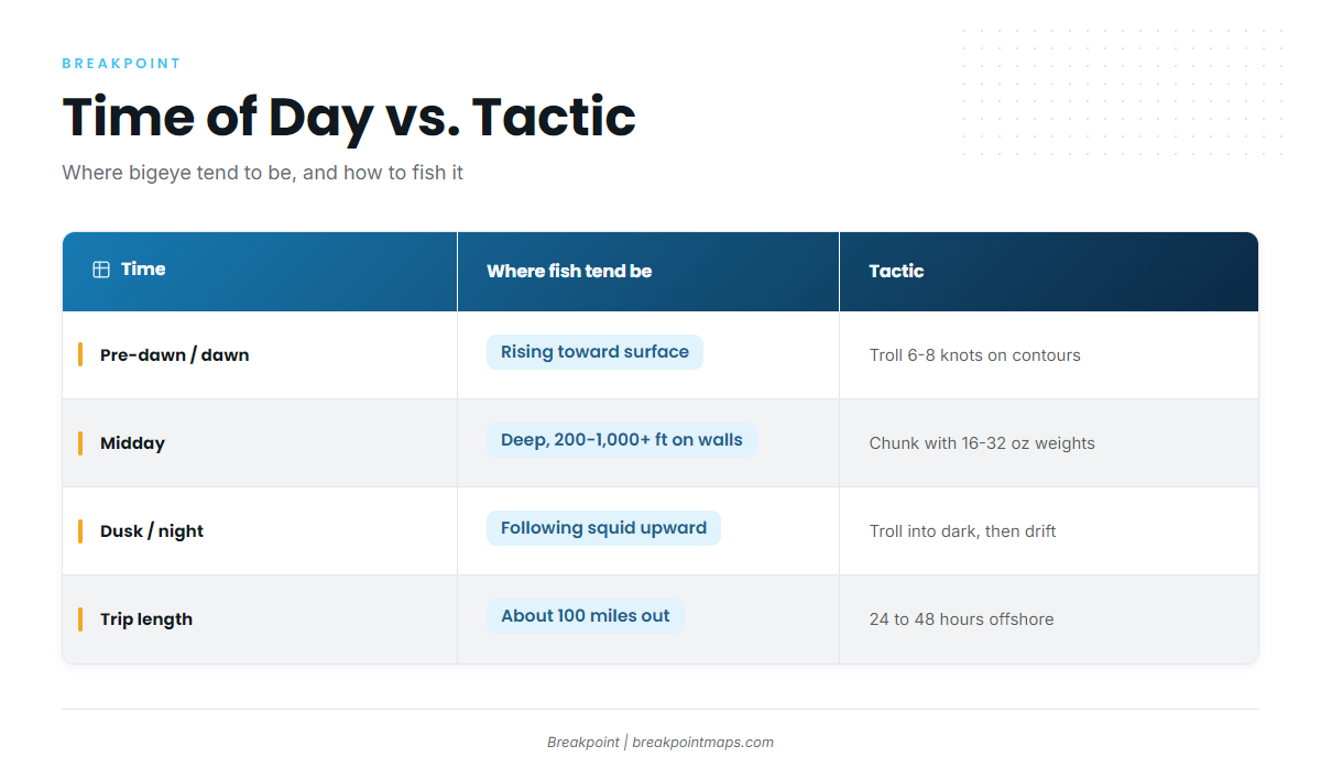
Match the tactic to the time of day. Bigeye come up when the light goes and go down when it returns.
| Time | Where fish tend to be | Tactic | Source |
|---|---|---|---|
| Pre-dawn / dawn | Rising toward surface | Troll 6 to 8 knots along contours; deep-diving plugs, bars, ballyhoo | The Tackle Room; On The Water |
| Midday | Deep, 200 to 1,000+ ft on walls | Chunk to pull fish up; 16 to 32 oz drop weights | The Tackle Room |
| Dusk / night | Following squid upward | Troll into dark, then drift, chunk or jig | Sport Fishing |
Pre-Dawn and Dawn
Get back on the troll before first light, working bait and deep structure. Sport Fishing recommends trolling a few hours into the dark, resting the crew, then resuming before dawn.
The Tackle Room suggests 6 to 8 knots along the contours, varying speed periodically. On spread, On The Water says deep-diving plugs such as the Shimano Ledge Runner have become staples. Spreader bars and ballyhoo round out a typical canyon spread.
Midday
By day bigeye cruise canyon walls at 200 to 1,000 feet or deeper, and a chum slick pulls them up. According to The Tackle Room’s chunking notes, run a Chumchunker or similar device to spread chunks downcurrent while your baits soak. The scent trail and visual cues bring fish up the water column.
The Tackle Room also says drop weights of 16 to 32 oz keep baits in the strike zone in strong current.
Dusk and Night
Sport Fishing’s advice is to troll a few hours into the dark, then drift and rest the crew, but not for too long. Chunk or jig where squid show on the sounder. Squid rise, and bigeye follow. Luresnline cites bigeye at 400 to 500 feet by day and up to 100 feet at night.
Trip Logistics and Safety
Budget for a 24 to 48 hour trip, substantial fuel reserves and a favorable weather window, as the Sport Fishing and Cape Cod accounts stress.
Frequently Asked Questions
When do bigeye arrive in the Northeast canyons?
According to On The Water, bigeye move up from the Carolinas starting in late June and are settled from Hudson Canyon to the Hague Line by late July. They hold until water drops below about 65°F in late fall.
What depth do bigeye hold in Hudson Canyon and the Northeast canyons?
On The Water reports about 95% of rod-and-reel bigeye come from 100 to 400 fathoms, with a sweet spot of 150 to 350. The Fisherman puts the preferred range at 100 to 250 fathoms. Start at the 100-fathom line and work deeper.
Do I need an HMS permit for bigeye?
Yes. Anglers targeting bigeye need a federal HMS Angling permit on a private boat. For-hire vessels carry the HMS Charter/Headboat permit. Verify current requirements at NOAA HMS before you fish.
Are bigeye and yellowfin found together?
Often, and sometimes on the same troll. Yellowfin rarely go deeper than 200 fathoms, while bigeye range well below that. Correct identification matters for retention and reporting.
Close
Canyon water changes by the day, and where the fish will be is never certain.
To help with that decision, Breakpoint’s hotspots feature scores bigeye tuna in the Atlantic Northeast using sea surface temperature, chlorophyll and bathymetry. A score is a forecast and a starting point for a decision, not a promise of fish.
Chart layers are not for navigation.