Overview
Mahi-mahi fishing in the Atlantic Southeast depends mostly on how far your port sits from the Gulf Stream, which ranges from a short run off the Keys to a much longer one off the Carolinas. That distance affects when the fish show up, how much fuel you burn, and which edges are worth fishing.
This page covers the regional questions. For biology, general rigging, and why the fish is worth chasing, see our Mahi-Mahi species guide.
The fish is dolphinfish (Coryphaena hippurus), called dolphin in the regulations, which is why the rules tables below say "dolphin (mahi-mahi)." The NOAA Fisheries Atlantic mahi profile describes them as pelagic fish of offshore temperate, tropical and subtropical waters. NOAA lists the population level of the South Atlantic stock as unknown, since it has not been formally assessed. Keep that in mind when deciding how many fish you need.
The page covers:
- When the fish move through each stretch of coast
- How far you run
- What edges and weed to look for
- What to put in the water
- What the law says, by jurisdiction
Regional Differences
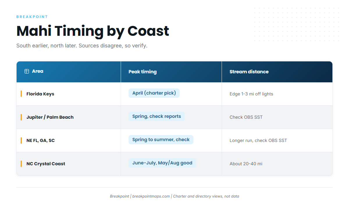
Mahi timing moves south to north with the Gulf Stream. The Keys and South Florida peak in spring, and the Carolinas peak in early summer.
Florida Keys and South Florida. A Keys charter’s advice is direct: "If you can only pick one month for mahi in the Florida Keys, pick April." The same source notes the chance of tailing, surface-feeding fish within sight of the reef. That is a charter’s view rather than survey data, but it matches the northbound migration pattern.
The Carolinas. One charter directory lists Atlantic Beach mahi season as June and July, with good catches in May and August. It also says warm blue water is "often found within 30 miles of shore" off the Crystal Coast.
Run distance. Off North Carolina, a tackle retailer’s offshore tackle guide puts the Stream within about 20 to 40 miles of the coast, depending on season. In the Keys, the charter source says you are in range when the edge comes within 1 to 3 miles of Tennessee Light (Islamorada) or Sombrero Light (Marathon). Jupiter and Palm Beach runs are shorter than the Carolinas. Off Georgia and South Carolina the shelf is wider and runs are longer. Check the current Stream position on OBS SST before you commit fuel. Chart layers are not for navigation.
Published season windows disagree with each other. Some sources say April through June, others April through September in northern waters and April through October in southern waters. The general direction holds: south earlier, north later.
Size classes. Young mahi school, while larger mature fish tend to travel more alone. Bulls show the steep, flat forehead. Many captains and anglers report smaller fish and weaker spring runs in recent seasons. We treat that as widely reported rather than measured, and we have no regional size data to print.
| Area / ports | Peak timing (source) | Stream proximity (source) | Notes |
|---|---|---|---|
| Florida Keys (Islamorada, Marathon) | April, if you pick one month (charter) | Edge within 1 to 3 mi of Tennessee/Sombrero lights when in range (charter) | Atlantic and Gulf rules split |
| Jupiter / Palm Beach | Spring, check local reports | Check OBS SST | Verify Florida state rules |
| NE Florida, Georgia, South Carolina | Spring into summer, check local reports | Longer run, check OBS SST | 20-inch minimum applies in federal waters |
| NC Crystal Coast / Outer Banks | June and July peak, May and August good (Atlantic Beach directory) | About 20 to 40 mi, often within 30 mi of shore (tackle and directory sources) | No federal minimum size off NC as sourced |
Habitat & Conditions in the Atlantic Southeast
Mahi in the Atlantic Southeast hold where blue Gulf Stream water meets green water, where temperature breaks, and where Sargassum stacks up.
Temperature. The tackle guide says mahi rarely hold in water below 70°F, and that 74 to 78°F water with color and floating grass is "the zone." Treat that as a working range, not a rule.
Color change. Look for clean blue Stream water against green coastal water, with bait on the edge. In the Keys that shows up as a hard line where powder-blue Stream water meets green reef water.
Stream mechanics. The Stream meanders. Fingers push out from the main flow and get reabsorbed. Eddies and finger edges over steep bottom are productive, and upwelling occurs where the Stream presses against the shelf. Fishing-forecast analysts describe this pattern in general terms. In the Keys, a charter reports that sustained NE winds in March and April push the western edge toward the Upper Keys reef.
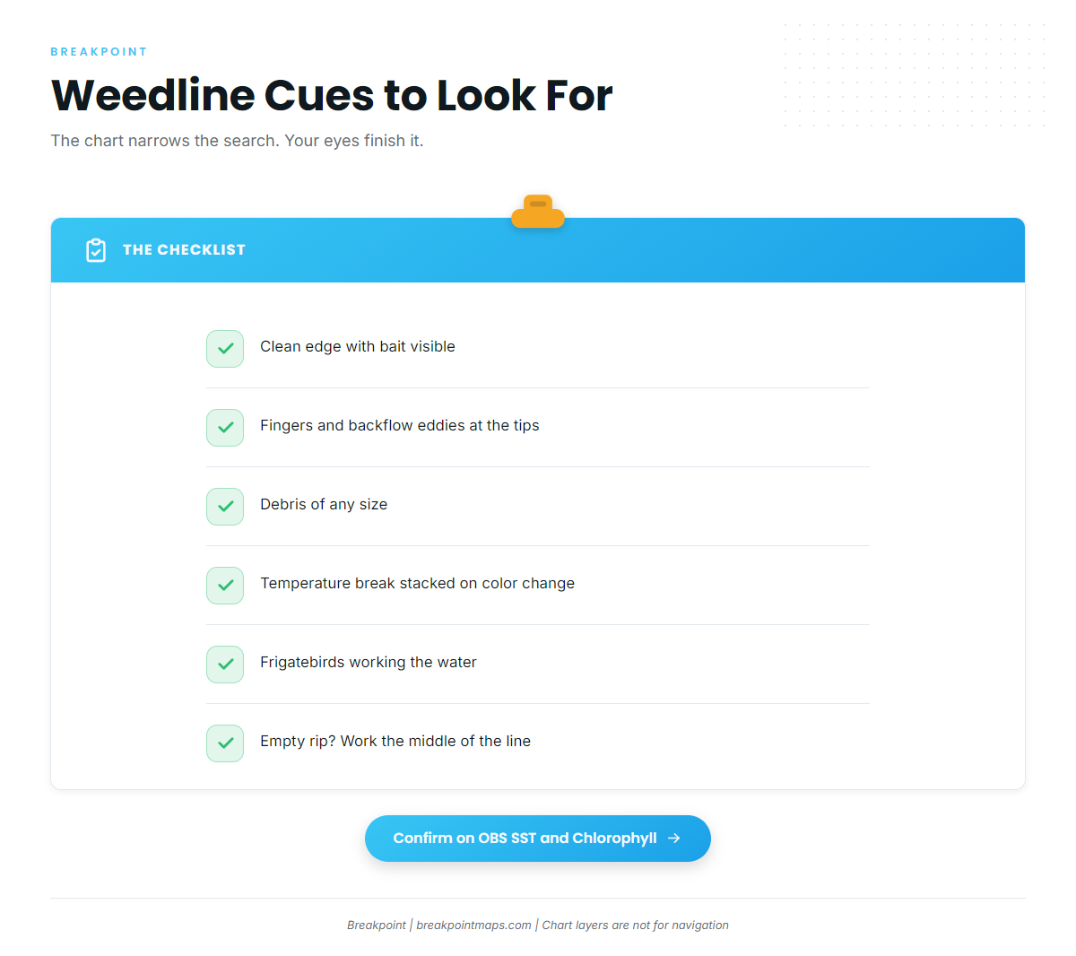
Weedline cues. A weedline is not automatically a fishing line. Look for:
- A clean edge with bait visible
- Fingers and backflow eddies at the tips
- Debris of any size, since it does not need to be big
- A temperature break stacked on a color change
- Frigatebirds working, since they cannot dive and follow fish pushing flying fish
- If the rip is empty, work the middle of the line
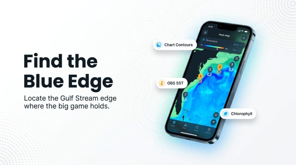
Named bottom features. The Point off Hatteras and the Charleston Bump are well-known places where the Stream meets the shelf. Use Chart Contours to see where the Stream meets steep bottom near your port.
Data layers. Each layer answers one question:
| Layer | What it shows | What it cannot see |
|---|---|---|
| OBS SST | Temperature breaks and the Stream’s shoreward edge | Anything under cloud cover |
| Chlorophyll | The green-to-blue color transition | Clouds block satellite passes here too |
| Chart Contours | Steep bottom where the Stream meets the shelf | Unsurveyed seabed |
Chart layers are not for navigation.
Limits. Clouds block satellite passes, models are forecasts, Sargassum does not show on SST, and weedlines move overnight with wind and current. The chart narrows the search, and your eyes finish it.
Tactics for the Atlantic Southeast
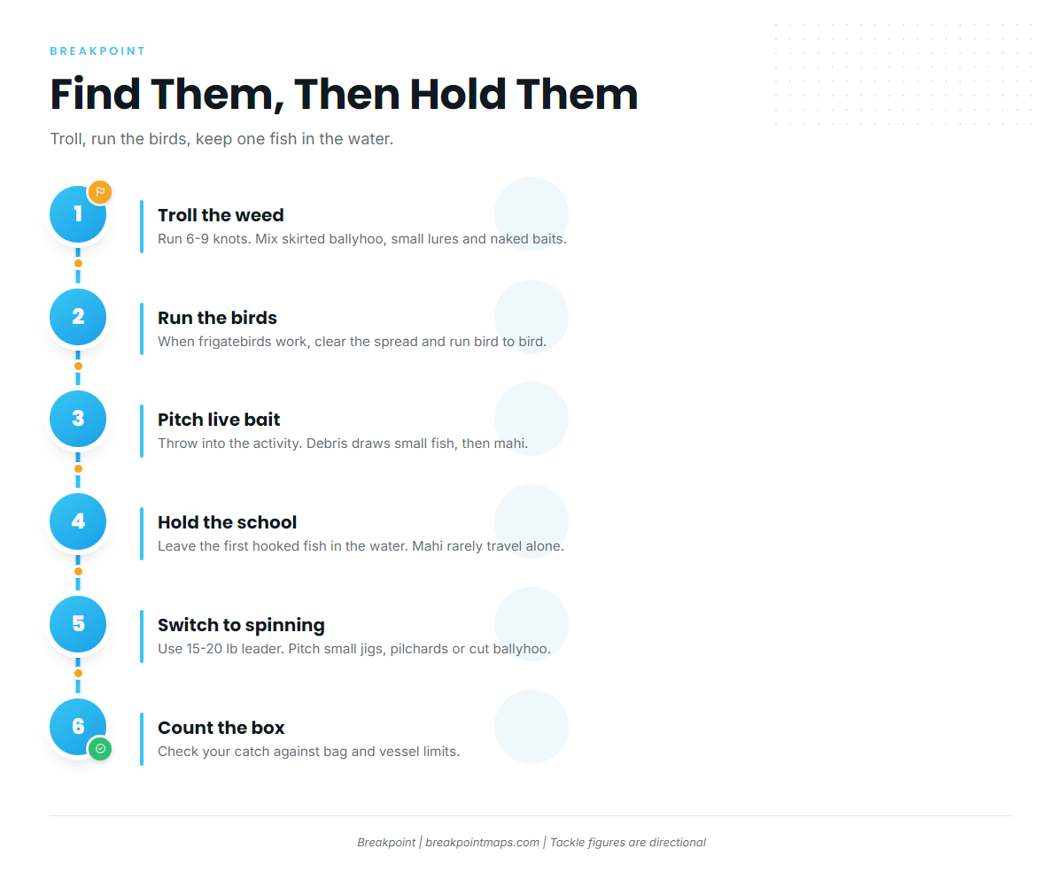
Troll to find fish, run the birds when they show, and keep a hooked fish in the water to hold the school.
The basic dink rig is covered in the species guide. What follows is what changes locally.
Trolling the weed
Trolling covers water fast and finds scattered fish. The tackle guide gives the standard spread at 6 to 9 knots, a mix of skirted ballyhoo, small lures and naked baits, with rigged ballyhoo at 7 to 9 knots as its most reliable bait.
A typical local spread looks like this:
- Skirted ballyhoo on the short and long lines
- Small lures in the mix to cover different depths in the wash
- Naked ballyhoo on the dink rig: 6 ft of 60 lb mono, a 6/0 or 7/0 O’Shaughnessy hook, and a 1/4 oz egg sinker as a chin weight
- The spread patterned along the weedline edge, then worked through the fingers and eddy tips
Trolling the same weedlines also draws wahoo, so expect the occasional one.
Birds and run-and-gun
When frigatebirds are active, clear the spread and run from bird to bird. Pitch live bait into the activity. Debris draws small fish, and small fish draw mahi.
Holding the school
Mahi rarely travel alone. Leave the first hooked fish in the water. Switch to spinning gear with a 15 to 20 lb leader and pitch small jigs, live pilchards or cut ballyhoo. Count the box against the bag and vessel limits before the school gets going.
Keys sight fishing
In April off the Keys reef, tailing fish call for a different approach. Pull all trolling lines and cast within 3 ft ahead of the fish.
Frequently Asked Questions
What is the best month for mahi in the Florida Keys?
April, according to a Keys charter. It cites tailing fish near the reef and the start of the push north. That is a charter’s view, not survey data, so treat it as a strong local read and check current reports before you book.
How far offshore is the Gulf Stream off North Carolina?
About 20 to 40 miles depending on season, and often within 30 miles off the Crystal Coast, per tackle and charter sources. The edge moves, so check OBS SST before the run. Chart layers are not for navigation.
Is Florida’s dolphin bag limit different from the federal limit?
Yes. Florida Atlantic state waters allow 5 per person and 30 per private vessel, per FWC. Federal waters allow 10 per person and 54 per vessel, per SAFMC. Verify both before you fish.
What is the minimum size for mahi in the South Atlantic?
20 inches fork length in federal waters off Florida, Georgia and South Carolina, per SAFMC. As sourced, there is no federal minimum off North Carolina. State rules may differ, so verify with the agency.
Closing
Long Stream runs need a real weather window. Weed moves overnight, and the stock is unassessed, so take only what you will use.
Mahi-mahi fishing in the Atlantic Southeast rewards picking the right edge over running the farthest. If you want help with that call, Breakpoint’s hotspots feature scores mahi-mahi in the Atlantic Southeast each day, using temperature, color, currents and structure, and shows why each pin is there. Scores are a starting point, and the water decides. Chart layers are not for navigation.