Overview
White marlin arrive from the south, ride the Gulf Stream and its eddies onto the shelf, and work north canyon by canyon. Fishing them in the Atlantic Northeast means reading water more than following a fixed calendar. For species ID, general biology or basic tackle, start with our white marlin species guide. This page covers only what changes in the Northeast.
The fishery is a seasonal feeding migration rather than a resident population. Timing runs south to north, so the Virginia and Maryland canyons produce before Hudson, Block and Atlantis do. Warm-core eddies decide who gets fish and when, and most fish are released under federal HMS rules.
Below you’ll find when, where and how, region by region, plus the rules to check before you leave the dock.
Regional Differences
White marlin reach the Mid-Atlantic canyons in summer and work north toward Hudson, Block and Atlantis as the season goes on. Peak timing varies by latitude and by year.
The NC DEQ white marlin profile sets the baseline. The northward migration off the U.S. runs May through October, and white marlin use waters warmer than 66°F. Northeast timing in any given year depends on where that warm water sits.
The Run Arrives From the South
White marlin typically show up in July somewhere between Spencer and Poor Man’s canyons. Once they leave the Stream, fish spread along the shelf, following water temperature and bait.
Sources disagree on the peak:
- Some charter sources call July and August the best months.
- Some put the peak in August.
- Some cite mid to late September.
- Marlin Magazine (2023) says fish end up in the Northeast canyons by late summer and early fall.
These accounts fit together once you account for the movement itself. The season moves south to north and shifts from year to year with the water. Southern canyons fish first, and northern canyons fish later, once the warm water reaches them.
Canyons From South to North
Running north, the canyons you’ll hear named are Norfolk, Washington, Poor Man’s, Baltimore, Massey, Wilmington, Lindenkohl, Spencer, Toms, Hudson, Block and Atlantis.
South Jersey boats have had a run on several of them. Recent South Jersey canyon reports list Spencer, Lindenkohl, Wilmington, Hudson, Toms, South Toms and Massey as producing. Block and Atlantis depend most heavily on eddies reaching that far north. When one does, they can fish well; when one doesn’t, the fish may simply not be there.
Ports and Timing at a Glance
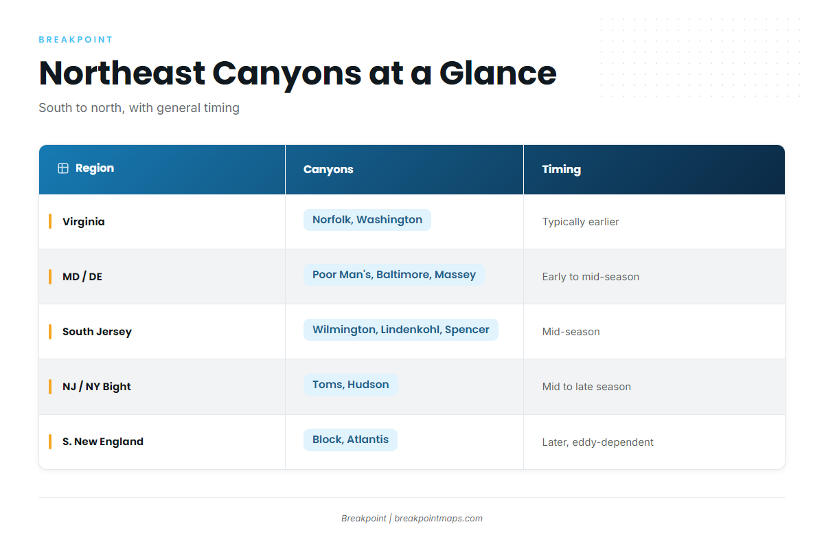
| Region | Canyons | Nearest ports | General timing |
|---|---|---|---|
| Virginia / southern Mid-Atlantic | Norfolk, Washington | Virginia Beach | Typically earlier |
| Maryland / Delaware | Poor Man’s, Baltimore, Massey | Ocean City | Early to mid-season |
| South Jersey | Wilmington, Lindenkohl, Spencer | Cape May | Mid-season |
| North Jersey / New York Bight | Toms, Hudson | Manasquan and other NY/NJ inlets | Mid to late season |
| Southern New England | Block, Atlantis | Montauk, Point Judith | Later, eddy-dependent |
Ocean City is the anchor port for the fishery. The 2026 White Marlin Open ran August 3 to 8 out of Ocean City, so expect heavy tournament traffic in early August when you plan. Midweek trips can mean less pressure on popular spots. Ask the captain about current water before you commit dates, since they can steer you toward the best window within yours.
Charter boats fishing for HMS carry the HMS Charter/Headboat permit. See the Regulations section for the rest.
Habitat & Conditions in the Atlantic Northeast
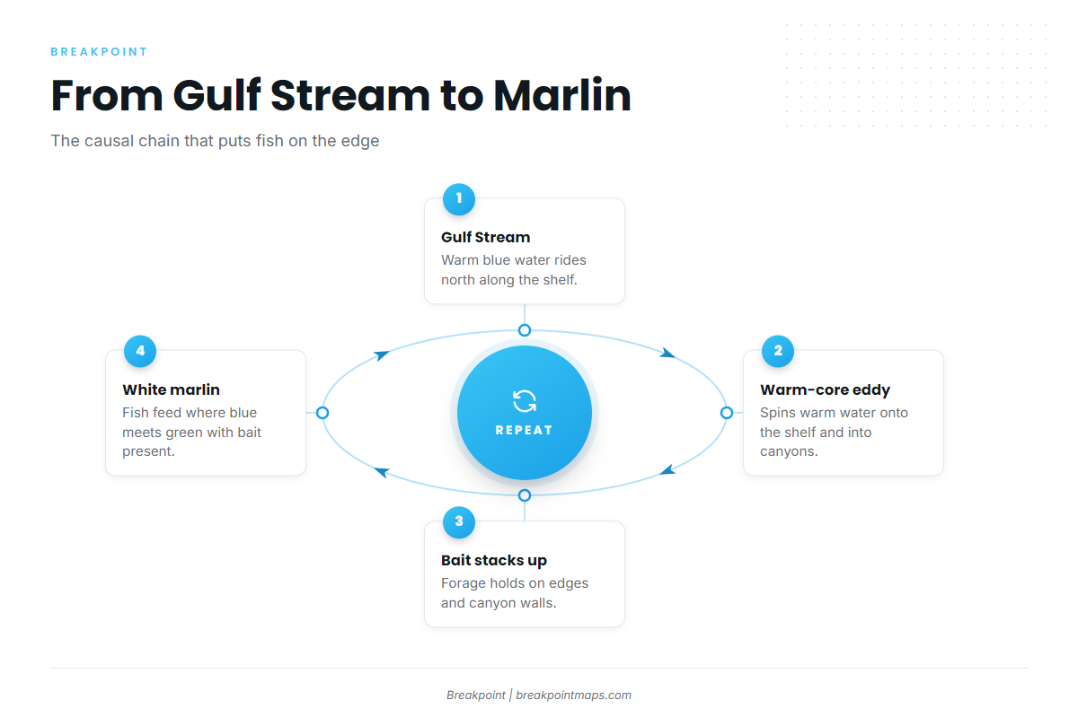
In the Northeast, white marlin tend to hold where warm blue Gulf Stream water, often pulled onshore by a warm-core eddy, meets greener shelf water along canyon walls and the shelf edge, with bait present. The chain runs from the Gulf Stream to eddies that pull warm blue water onto the shelf, then to bait stacking on edges and canyon walls, and finally to marlin.
Warm-Core Eddies and the Gulf Stream
Warm-core eddies are the biggest swing factor in this fishery. White marlin move closer to shore with them. Anglers describe clockwise eddy circulation pulling warmer, bluer water up into the canyons, concentrating bait and marlin where it arrives.
As an example, if a warm-core eddy is sitting on the south wall of Hudson Canyon, we’d start at the edge where it meets green shelf water. Then we’d look for bait and birds along that edge before setting a spread.
Temperature and Color Edges
According to NC DEQ, 66°F is the biological floor. Within that, angler consensus puts the preferred range in the mid-70s. A single number matters less than the break: the working edge is usually the blue side of a color change, lined up against a temperature break.
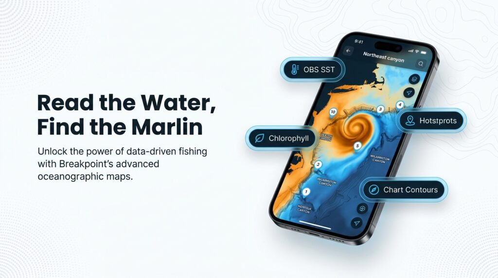
Two layers in Breakpoint help you see it:
- OBS SST shows observed surface temperature, so you can spot breaks and where an eddy’s edge sits.
- Chlorophyll shows water color, so you can see where green shelf water gives way to clean blue.
Shelf Edge and Canyon Structure
Look at the shelf edge and the canyon walls and tips, where structure pushes bait up and holds it. The Chart Contours layer helps you read where walls steepen and where a canyon head cuts in.
Depth in the water column matters too. NC DEQ says white marlin use the upper 40 to 100 feet. One Mid-Atlantic captain’s approach is to watch the sounder "from 300 feet up to the surface" for bait and marks, because what sits below the fish often tells you why they’re there.
Bait and Signs on the Water
White marlin feed near the surface in daylight, per NC DEQ. The diet list runs to mackerels, herrings, dolphin, flyingfish, squids and crabs. Fish can cut bait on the surface for only 10 or 15 minutes before going deep, so birds keep sitting and waiting for them to return. Watch for birds, slicks and bait balls.
Squid and butterfish are managed forage in this region under the Mid-Atlantic Fishery Management Council. Billfish are managed separately, by NOAA Fisheries HMS under ICCAT rather than by the regional councils.
What the Data Can’t Tell You
A satellite pass blocked by cloud leaves gaps in the SST picture, and SST shows only the surface, not what’s happening 100 feet down. A forecast is a forecast, and an observation is a snapshot that ages by the hour.
Use the maps to narrow where to look, then let the water, the bait and the birds decide. Chart layers are not for navigation.
Tactics for the Atlantic Northeast
The local standard is small ballyhoo on small circle hooks and light tackle, pulled around dredges and teasers. The spread is built to raise fish and then feed them a bait they can swallow cleanly. The species guide covers rigging basics, so this section sticks to the regional approach.
The Local Ballyhoo Spread
One Northeast writer recommends a dedicated circle-hook dead-bait spread built on small baits, small circle hooks and light line. In practice, the spread looks like this:
- Small rigged ballyhoo on circle hooks, fished behind the boat
- One or more dredges to hold fish in the pattern
- Teasers to raise fish and pull them in
- A pitch bait rigged and ready for a bait-and-switch
Dredges, Teasers and Bait-and-Switch
A subsurface dredge, fished from outriggers, a dredge boom or a handline, is one of the most effective billfish teasers. Anglers debate whether a dredge raises marlin on its own, but most agree it brings fish closer to the boat and keeps them in the spread.
In a bait-and-switch, a marlin shows behind a teaser or dredge. You pull the teaser away, present a rigged bait, and let the fish eat it, so the fish ends up with a meal it didn’t know it was chasing. Have the pitch bait rigged before the fish shows, because there won’t be time to build one.
Casting to Tailing Fish
When a marlin is tailing on the surface, a live eel, scup, mackerel or bluefish on a circle hook, cast into its path, will often be eaten.
Circle Hooks and Tackle
One angler’s setup is a Shimano Talica 25 with 25 or 30 lb monofilament. That is one angler’s choice, not a rule. The 20 to 30 lb class is common in the canyons, and light line makes for better fights. Circle hooks matter for release survival, and there’s a federal rule behind them. Confirm the exact scope in the Regulations section.
The Yellowfin Chunk Crossover
Marlin trips often overlap with tuna water. One angler in the Press of Atlantic City report went 4 for 7 on yellowfin, chunking on light line at Massey while trolling for white marlin. That is a single report, not a pattern. Still, the same edge that holds marlin can hold tuna, so many crews plan to run both options in one trip.
Frequently Asked Questions
When is white marlin season in the Northeast canyons?
Fish typically arrive in July in the southern canyons and work north. Peaks vary by source and by year, with some pointing to July and August and others to mid to late September. NC DEQ puts the northward migration at May through October. Ask your captain about current water before booking.
What’s the size limit for white marlin?
Billfish minimum sizes are measured by lower jaw fork length. Confirm the current white marlin figure on NOAA’s billfish page before you fish. NOAA also caps U.S. landings of blue marlin, white marlin and roundscale spearfish combined at 250 per year, so retention is rare.
Do I need an HMS permit on a charter?
The charter vessel carries an HMS Charter/Headboat permit. If you run your own boat, you need an HMS Angling permit for recreational fishing. Confirm the current permit requirements on NOAA Fisheries before you go.
Are circle hooks required?
Circle hooks are required in some circumstances with natural bait. The exact scope, including tournaments and hook type, is set by NOAA. Check NOAA’s current rule before you fish, and use circle hooks either way for better release survival.
Where to Look Next
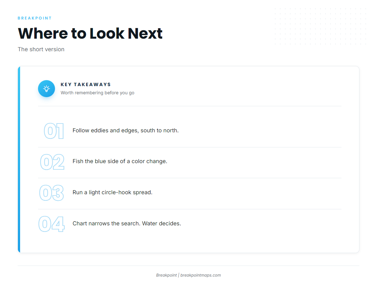
Follow the eddies and edges from south to north, and fish a light circle-hook spread around dredges and teasers.
Breakpoint’s hotspots feature scores white marlin across the Northeast canyons, alongside the OBS SST and Chlorophyll layers. Use it to narrow where to look, then trust what you see on the water. Chart layers are not for navigation. Check NOAA’s rules before each trip.