Yellowfin fishing in the Gulf of Mexico depends on structure and current more than open-ocean fishing does: rigs, lumps, canyons and whatever the Loop Current is doing this week. Biology, general tackle and identification are in our yellowfin tuna species guide. This page covers only what changes in the Gulf.
Four things set this water apart:
- Fish are present year-round.
- There is a summer spawn in the northern Gulf.
- The fishery leans on oil and gas platforms and named bottom features.
- Current and color edges move from week to week.
Federal sources, including NOAA, now call this water the Gulf of America. We use Gulf of Mexico here because that’s what most anglers search.
Below are where to look, when by port, which tactics local operators use, and the current rules.
Regional Differences
Gulf yellowfin are here all year, spawn in the northern Gulf in summer, and hold tighter to structure than fish in open Atlantic water.
Year-Round Presence and the Summer Spawn
Louisiana charter operators report catching yellowfin all year, and there is no closed season.
The spawning window matters for planning. According to NOAA’s Atlantic yellowfin profile, western Atlantic yellowfin spawn from May to August in the Gulf. The same page reports that the 2024 assessment found the stock not overfished and not subject to overfishing. Summer fish are part of that spawning population, which is a good reason to keep only what you’ll eat.
Seasonal Size Patterns (as Reported)
Louisiana operators commonly report fish in the 40 to 60 lb range, with larger fish in the cooler months. According to a Venice charter operator, winter schools sit at the Midnight Lump, while summer fish spread across the Gulf. These are operator reports, not survey data, and size runs vary year to year.
Structure Dependence
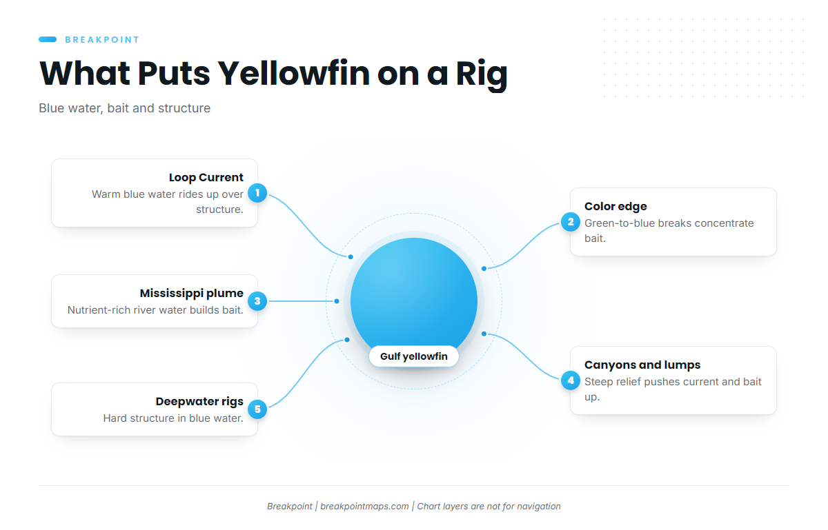
Platforms and lumps put hard structure in blue water. Current piles bait against it, and tuna key on the bait.
Sport Fishing Mag’s reporting on Louisiana research lists menhaden, jacks, flying fish, mackerel and small tuna, including blackfin, among common prey. It also reports that Louisiana ports land more yellowfin, recreational and commercial, than any other Gulf state. That is much of the reason Louisiana anchors this guide, and the Louisiana’s yellowfin research findings are worth reading in full.
Platform decommissioning and Rigs-to-Reefs are changing the structure map, and how removals affect where tuna hold isn’t well documented yet. Check your numbers against current platform status before a long run.
Port and Season Table
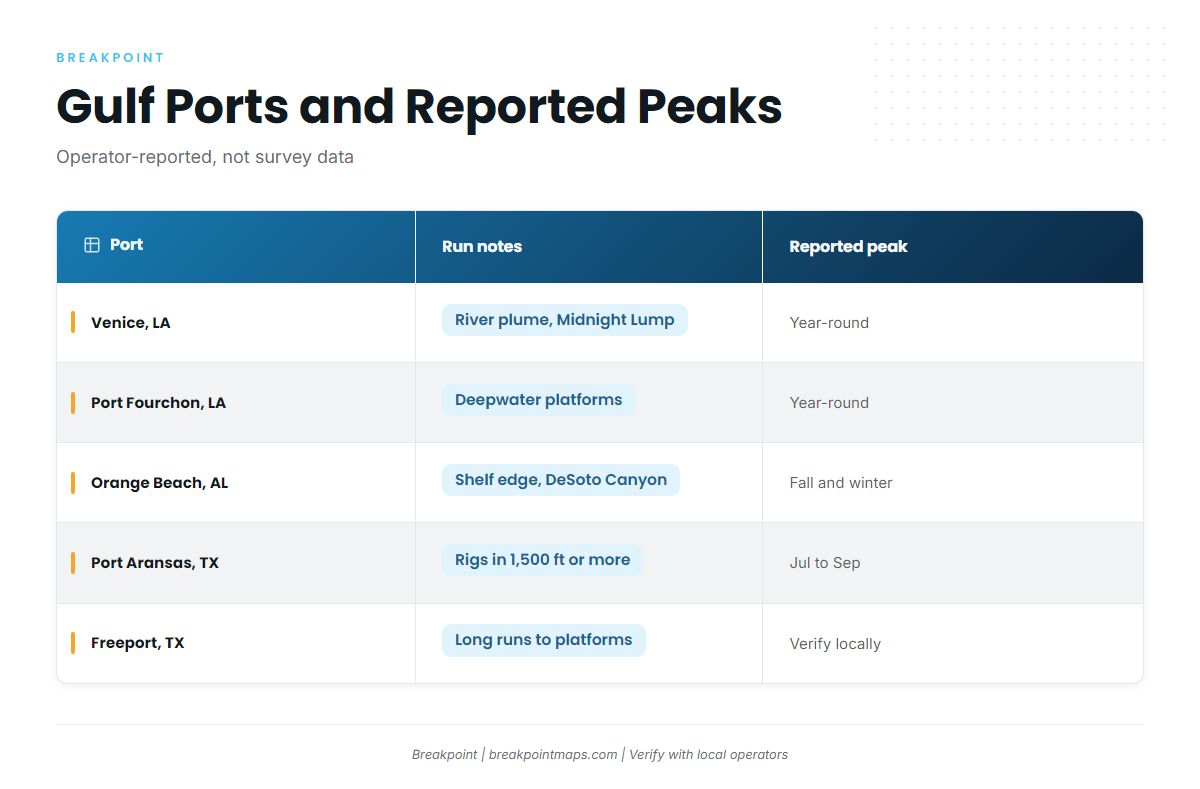
Use this to match a port to a season. Where a cell has no sourced month, the table says so.
| Region / port | Run notes | Reported peak months | Source |
|---|---|---|---|
| Venice, LA | Mississippi River plume, rigs, Midnight Lump, Mississippi Canyon | Year-round. Cooler months reported for larger fish (operator-reported) | Louisiana charter operators |
| Port Fourchon / Grand Isle, LA | Deepwater platforms offshore | Year-round (operator-reported) | Louisiana charter operators |
| Orange Beach, AL / Florida Panhandle | Shelf edge, DeSoto Canyon, rigs to the west | Fall and winter commonly cited | Charter operators |
| Port Aransas, TX | Deepwater rigs. Operators point to rigs in 1,500 ft or more | July to September | Port Aransas operators |
| Freeport / Port O’Connor, TX | Long runs to deepwater platforms | Year-round, verify with local operators | None sourced |
Peak months are what charter operators report, not survey data. The Loop Current and eddy positions can shift a season by weeks. For Texas, Port Aransas tuna season reporting puts high season at July through September.
If you’re booking a charter, note that a for-hire boat fishing for tuna needs its own HMS Charter/Headboat permit, which generally covers paying anglers aboard. Confirm with the captain and NOAA HMS before you book.
Habitat & Conditions for Yellowfin Tuna Fishing in the Gulf of Mexico
In the Gulf, yellowfin follow blue water and bait, and the Loop Current determines where both end up.
The Loop Current and Warm-Core Eddies
Sport Fishing Mag describes Loop Current eddies meeting Mississippi River outflow above deep canyons, along a shelf edge full of rigs. The same article notes that whether the current stays high north, retracts south or sheds eddies shifts the better fishing between Florida, Alabama, Mississippi and Louisiana.
ROFFS Gulf conditions preview analysis describes rotating eddies circulating warm blue water over rigs and good bottom.
In practice, warm clean water rides up over structure, and the edge between it and greener shelf water concentrates bait. Eddies drift and detach, so a position from last week is a starting point, not a waypoint.
Temperature and Color Edges
Temperature breaks come first, followed by color breaks: green-to-blue transitions and plume edges. Look for the break itself.
The Mississippi River Plume Near Venice
Nutrient-rich river water builds bait, and the plume creates a color edge against offshore blue water. Venice-area operators note that river discharge, and how close clean water pushes inshore, determine whether boats need to run out to the floaters.
Shelf Edge, Canyons and the Midnight Lump
Three named features anchor the northern Gulf:
- Mississippi Canyon, south and southwest of the river mouth.
- DeSoto Canyon, off the Alabama and Panhandle shelf.
- The Midnight Lump, a salt-dome feature south of the Louisiana coast.
Steep relief and the shelf break push current and bait upward. Winter schools at the Midnight Lump are operator-reported.
Deepwater Rigs and Floaters
Salt Water Sportsman describes running rig to rig and looking for strong current and fish busting on the surface. That routine can end with you about 120 miles from shore.
Port Aransas operators point to rigs in 1,500 ft or more. At night, rig and floater lights draw bait to the surface. The decommissioning caution above applies here too.
How to Read SST and Chlorophyll Before You Run
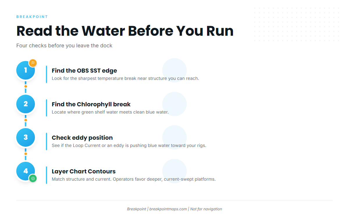
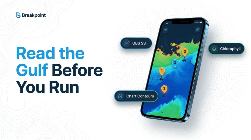
Read the water in this order before you commit fuel:
- OBS SST edge. Find the sharpest temperature break near structure you can reach.
- Chlorophyll break. Find where green shelf water meets blue.
- Eddy position. Check whether the Loop Current or a detached eddy is pushing blue water toward your rigs.
- Rig depth and current. Use Chart Contours to put structure and current together. Deeper, current-swept platforms are the ones operators favor.
The data has limits:
- Cloud cover blocks satellite passes, sometimes for days.
- SST shows the skin of the ocean, not what’s happening 100 ft down.
- Summer surface water can go uniformly warm, flattening temperature breaks.
- Eddy positions change week to week.
A chart gives you a better guess about where to look, but it isn’t a fish report. Chart layers are not for navigation.
Tactics for the Gulf of Mexico
Gulf tactics follow the bait source: rigs, shrimp boats, the plume and open-water edges. General tackle setups and trolling basics are in our yellowfin tuna species guide. What follows is what changes in the Gulf.
Choosing Which Rigs to Fish
Salt Water Sportsman’s approach is to look for strong current and surface activity, and if a rig is dead, move on quickly.
Pre-plan a string of platforms along the edge you found on SST, so a dead rig costs minutes rather than the day. Long runs need fuel and weather margins, so plan for the 120-mile end of the range before you leave the dock.
Chunking at Shrimp Boats
The Venice charter operator reports that shrimp boat bycatch draws yellowfin, especially September to October. Operators also chunk cut bonito or blackfin. The culled bycatch works as a natural chum slick. Keep a respectful distance and don’t foul the shrimper’s gear.
Night Work at Lit Rigs
Lights pull bait up, and tuna follow bait to the surface. Operators report using popping, jigging and chunking at night. Night runs around platforms demand radar and conservative speed. Chart layers are not for navigation.
Trolling Current and Color Edges
Gulf operators commonly troll rigged ballyhoo, small skirted baits and cedar plugs along edges and weed lines.
Live Bait and Kites
Operators fish live hardtails, such as blue runners, at rigs and under kites for larger fish.
Yellowfin or Blackfin
Both show up at the same rigs and in the same slicks. Identification details are in the species guide.
Frequently Asked Questions
When is the best time for yellowfin in the Gulf of Mexico?
Fish are present year-round. Peaks vary by port and are operator-reported: July to September at Port Aransas, and larger fish reported in cooler months off Louisiana. The Loop Current can shift any of these windows by weeks.
Are yellowfin in the Gulf year-round?
Yes, according to Louisiana operators. NOAA also reports a May to August spawn in the northern Gulf, so summer fish are spawning fish.
Do I need an HMS permit on a charter?
The boat’s HMS Charter/Headboat permit generally covers paying anglers. Confirm with the captain and NOAA HMS before you book. You may still need a state saltwater license.
What is the yellowfin bag and size limit?
See NOAA Fisheries HMS for the current bag and minimum size, and note the date checked in the table above. Rules change, so verify before fishing.
Yellowfin or blackfin: how do I tell them apart?
Both are common at Gulf rigs. Identification details are in our yellowfin tuna species guide.
Where to Start
To pull those edges together before you leave the dock, our hotspots feature scores yellowfin water across the Gulf from OBS SST, Chlorophyll and Chart Contours. It helps you decide where to look and does not guarantee fish. Chart layers are not for navigation.