


Overview
The Mississippi delta pushes the coastline out toward the shelf edge, so deep water sits unusually close to the passes. That geography is why yellowfin tuna off Venice, Louisiana draw anglers from every Gulf state. For biology and general tactics, start with our yellowfin tuna species guide. For seasonality and the Loop Current across ports, read our Gulf of Mexico yellowfin guide. This page covers only Venice.
It includes:
- The run and the structure.
- How to read the river’s color lines.
- A comparison of the seasons.
- Tactics organized by what you find on the water.
- A dated legal checklist.
Regional Differences
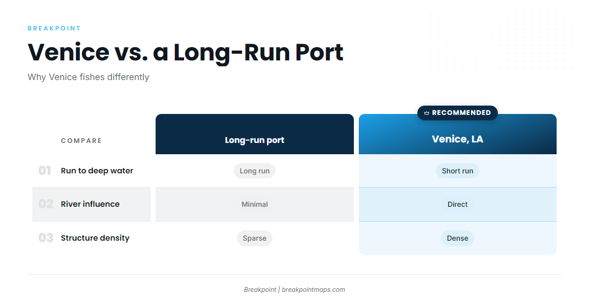
Venice differs from Texas, Alabama and Florida ports in two ways. The run to deep water is short, and the Mississippi River dumps fresh, muddy, nutrient-heavy water directly onto that edge. For Loop Current and other-port detail, go to the Gulf-wide picture.
NOAA now uses "Gulf of America." We use Gulf of Mexico here to match our regional guide.
On distance, a Venice guide platform reports that blue water 15 miles out from Venice takes a 50-mile run from other ports, and that yellowfin are caught as close as 5 miles from the marina. Check the distance against your own chart.
On the river, OutdoorHub credits nutrient-rich Mississippi water with supporting the large bait populations that draw tuna year-round. The same outlet covered the 256-pound fish near Venice, which we cover under Tactics.
| Factor | Venice | A generic long-run port |
|---|---|---|
| Run to deep water | Short, per charter operators | Long, often a major part of the day |
| River influence | Direct, and it moves the edge | Little to none |
| Structure density | Lumps, rigs and canyon close together | Sparser, more spread out |
The plume moves with discharge, so the edge moves with it. Plan your run around where the color change sits this week rather than where it sat on your last trip.
Habitat & Conditions at Venice, Louisiana
Yellowfin off Venice relate to three things:
- Deep structure close to the passes: lumps, rigs and the Mississippi Canyon.
- The line where muddy river water meets blue Gulf water.
- A winter-weighted trophy season.
The passes and the run
South Pass and Southwest Pass are the routes offshore. Charter operators report depths over 1,000 feet as close as 15 miles off Venice. MG Fishing lists offshore trips at 9-10 hours dock to dock, so budget the day accordingly.
A short run still means open-Gulf exposure. Pick a weather window you can come home in as well as go out in, and carry fuel margin for detours around a moving plume or weather. Charts in this article and any chart layers are not for navigation.
Structure: lumps, rigs and the canyon
The Midnight Lump is the best-known feature. Saltwater Sportsman’s Midnight Lump profile describes it as 200-250 feet deep and about 2.9 square miles, a spot where hundreds of boats were once common. Capt. Hunter Caballero of Paradise Outfitters said: "Probably 90 percent of the biggest yellowfins caught off Louisiana are caught on the Midnight Lump."
The same article notes that fishing has since been better on lumps to the east. Patterns move, so treat any single spot as a starting point.
Rigs make up the rest of the structure. Charter operators describe chunking around rigs, pumping stations and drillships. Platforms get removed or converted over time, so last season’s rig may be gone. Confirm current platform status with BSEE before you build a run around one.
Water: color lines, grass and temperature
Super Strike Charters says captains find productive grass lines where the muddy Mississippi meets clean blue Gulf water. Bait gathers along that break, and tuna follow the bait.
Some rules of thumb:
- If the water is green at the pass, keep running toward the edge.
- A sharp muddy-to-blue break with grass and birds is worth slowing down for.
- Green water with no break and no life is a reason to keep moving.
Check Mississippi discharge on USGS or NOAA river gauges before a trip. Tuna Town Fishing notes yellowfin showing in better numbers with the river running low. That is one operator’s observation and not a rule.
Sea-surface temperature and chlorophyll imagery are the data types that help you locate the edge.
When to go: what sources report
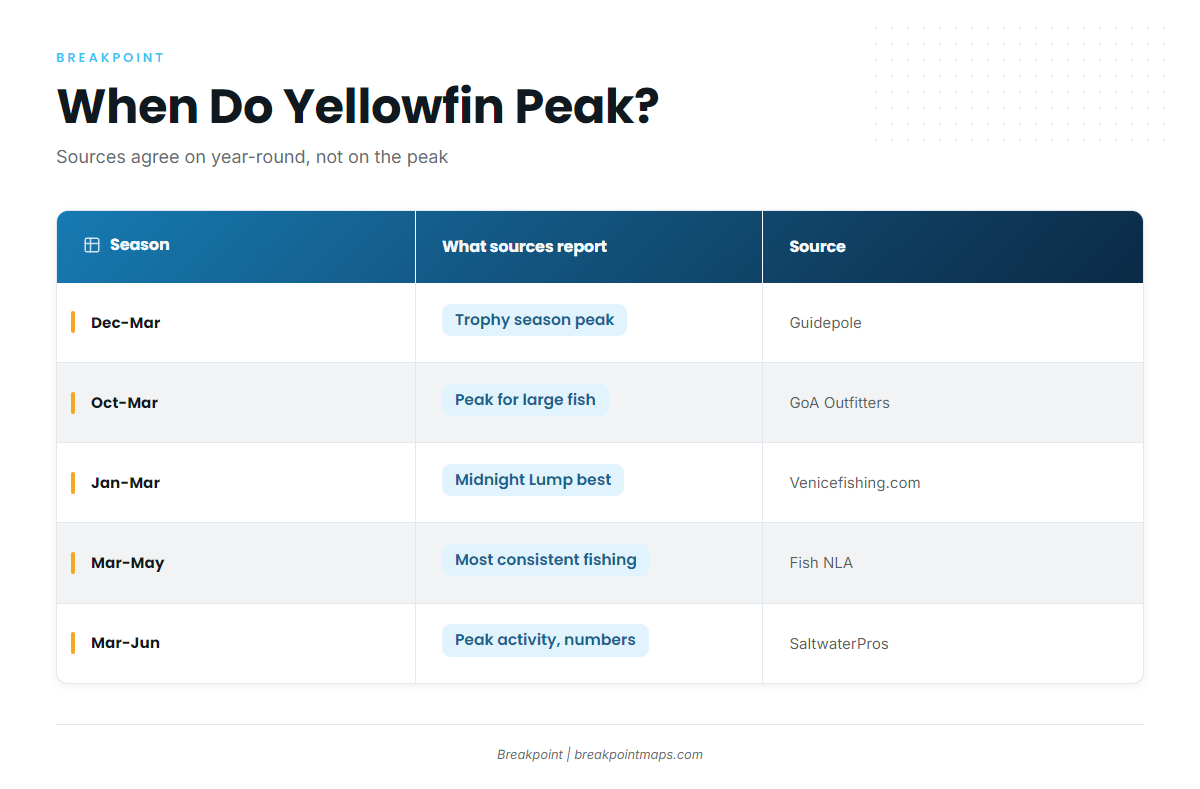
Yellowfin are caught year-round. Charter operators name different peak months, listed below.
| Season | What sources report | Source |
|---|---|---|
| Dec-Mar | Trophy season peak | Guidepole (guide platform) |
| Oct-Mar | Peak for large yellowfin; fishery active 12 months | Gulf of America Outfitters (charter) |
| Jan-Mar | Midnight Lump generally best | Venicefishing.com (charter) |
| Mar-May | Most consistent spring fishing | Fish NLA (charter) |
| Mar-Jun | Peak months for activity and numbers | SaltwaterPros (charter) |
Gulf of America Outfitters puts the October through March peak for large fish, while Fish NLA calls March through May the most consistent spring fishing.
Reported sizes vary. Venicefishing.com says most fish run 20-60 pounds, with larger fish in fall and winter. Gulf of America Outfitters cites 40-100+ pounds. Trophy-size fish skew toward the cooler months, and spring skews toward consistency, so the choice comes down to whether you want size or odds. If you want a winter trophy date, Go Long Charters says to book 6-12 months ahead.
What nobody can tell you in advance
- River pulses move the plume and the edge within days.
- Fish relocate. The shift from the Lump to the eastern lumps is a documented example.
- Weather windows decide the trip more than the calendar does.
- Rigs get removed.
- Cloud cover blocks satellite passes, so an SST image can be days old or have gaps.
Nothing here guarantees fish. The aim is a better decision about where to look.
Tactics for Venice, Louisiana
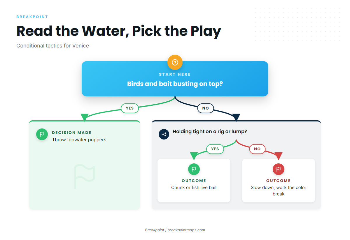
Yellowfin tuna fishing at Venice comes down to reading which of these situations you’re in. Standard tuna tackle is covered in the species guide.
If birds are working and bait is busting: throw topwater
OutdoorHub reports a 256-pound yellowfin caught Jan. 16, 2026 near Venice. The angler cast a topwater popper into a school of feeding fish on heavy spinning tackle with 80-pound braid, after the crew found heavy birds and bait early that morning. The prior record fish was 240.3 pounds, taken by Anthony Taormina at the Lump on March 18, 2005, per Saltwater Sportsman.
Saltwater Sportsman notes that blackfin hit topwater more willingly than yellowfin. Confirm the species before you count a fish toward your limit.
If you’re tight on a rig or lump: chunk or fish live bait
Venicefishing.com describes chunk lines around rigs, pumping stations and drillships. Other operators describe live bait, lures and jigs at the rigs. Match the method to what the school is doing: if fish are holding deep and quiet, chunks and live bait fit; if they are up and feeding, go back to topwater.
If you’re in mixed water at the edge: slow down and work the break
Grass, color and bait stack along the break. Slow down, run the length of it, and look for birds before you commit to a drift.
Frequently Asked Questions
What’s the yellowfin limit off Venice?
3 per person per day or trip, with a 27-inch minimum curved fork length, under NOAA Fisheries HMS rules.
How far is deep water from Venice?
Charter operators report depths over 1,000 feet about 15 miles out. The Midnight Lump sits at 200-250 feet, per Saltwater Sportsman. Verify distances on your own chart. Charts in this article are not for navigation.
Do I need an HMS permit?
Private boats need an HMS Angling permit, and for-hire vessels need a Charter/Headboat permit. Confirm this with NOAA HMS. Louisiana licensing still applies, and private anglers also need a ROLP.
When is the best time for large yellowfin off Venice?
Charter operators most often point to winter into March for trophy fish, and to spring for consistent fishing. Decide whether you want size or odds, then book accordingly.
Closing
Venice has a short run, a river that moves the edge, a season that depends on whether you want size or odds, and rules that combine federal and state requirements.
Before you commit fuel to a run, check where the river plume and the blue-water edge sit relative to the Midnight Lump and the canyon. Breakpoint’s OBS SST, Chlorophyll and Chart Contours layers show that. Chart layers are not for navigation, and the data narrows the search without deciding where the fish are.