




Sailfish fishing off the Florida Keys happens across Hawk Channel, on the outer reef line that Coast Pilot places about 5 miles off the keys, and out into the Straits of Florida with the Gulf Stream beyond. This page covers the Keys only: ports, channels, named water, the front cycle, tactics and rules. Our sailfish guide covers the fish and the general tackle. The aim here is a better decision about where to launch and where to look, not a promise of fish.
Ports and launch
NOAA Coast Pilot 4, Chapter 11 puts the reefs at an average of about 5 miles from the line of keys. In smooth weather no breakers mark them, and the water shoals abruptly on the outer edge of and between the reefs. In thick weather, trust soundings over sight.
Pick a channel before you pick a ramp:
- Check the controlling depth against your draft at the stage of tide you will run.
- Check bridge clearance against your T-top, outriggers and kite rods.
- Expect strong tidal currents in the cuts between the keys and cross currents in Hawk Channel near the openings.
Ramps for the Upper and Middle Keys are on the FWC boat ramp list. Confirm hours, fees and parking with the ramp operator.
Upper Keys: Key Largo and Islamorada
Key Largo is the northeast end of the same Hawk Channel and reef line. The patch reefs inside the reef line are bait water. For Key Largo ramps, use the FWC list.
For Islamorada sailfish, the FWC list names these ramps:
- Founder’s Park
- Plantation Key Boat Ramp
- Harbor Lights at Holiday Isle
- Indian Key Fill Boat Ramp
Marinas include Bud n’ Mary’s Marina (fuel listed), Whale Harbor Marina and Robbie’s Marina.
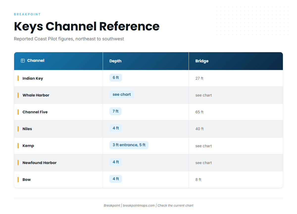
Two channels serve the oceanside. Whale Harbor Channel is the first. Indian Key Channel is about 200 yards wide and marked by daybeacons. Its reported controlling depth is 6 ft, with a fixed bridge at 27 ft clearance. It deepens with westerly winds and fills in with southeasterly winds.
Middle Keys: Long Key, Marathon and Sombrero Key Light
Sea Bird Marina on Long Key is on the FWC list. Channel Five lies about 8.4 miles west of Alligator Reef Light. Its reported controlling depth is 7 ft, and the fixed bridge has 65 ft clearance. A strong current sets through it at times.
For Marathon sailfish, build your plan around Sombrero Key Light and the Sombrero Key buoy, SMKF1. Coast Pilot describes Bahia Honda Channel as the deepest channel between the Straits of Florida and Florida Bay.
Lower Keys and Key West
Newfound Harbor, Niles, Kemp and Bow Channels carry older survey depths of about 3 to 5 ft.
- Niles Channel has a 40 ft fixed bridge and lies 18 miles west of Sombrero Key Light.
- Bow Channel has 8 ft vertical clearance and is not recommended for drafts over 2 ft without a pilot.
- Kemp Channel is heavily used by local boaters, and Coast Pilot advises local knowledge for strangers.
Launch from the bayside ramp on Cudjoe Key, or stage from Captain Hook’s Marina on Big Pine Key. For Key West sailfish, the Sand Key buoy, SANF1, is the reference station.
Launch and channel reference
| Area | Ramps and marinas | Channel | Controlling depth | Bridge clearance |
|---|---|---|---|---|
| Islamorada | Founder’s Park, Plantation Key, Harbor Lights, Indian Key Fill | Indian Key Channel | 6 ft | 27 ft |
| Islamorada | Bud n’ Mary’s, Whale Harbor, Robbie’s | Whale Harbor Channel | See chart | See chart |
| Long Key | Sea Bird Marina | Channel Five | 7 ft | 65 ft |
| Middle to Lower Keys | See FWC list | Bahia Honda Channel | Deepest channel to the Straits | See chart |
| Lower Keys | Cudjoe Key bayside ramp, Captain Hook’s Marina | Niles Channel | 4 ft | 40 ft |
| Lower Keys | Cudjoe Key bayside ramp, Captain Hook’s Marina | Kemp Channel | 3 ft entrance, 5 ft channel | See chart |
| Lower Keys | Cudjoe Key bayside ramp, Captain Hook’s Marina | Newfound Harbor Channel | 4 ft | See chart |
| Lower Keys | Cudjoe Key bayside ramp, Captain Hook’s Marina | Bow Channel | 4 ft | 8 ft |
Swipe the table sideways to see every column.
Depths are reported Coast Pilot figures. Shoaling changes them, so check the current chart.
Where sailfish hold off the Florida Keys
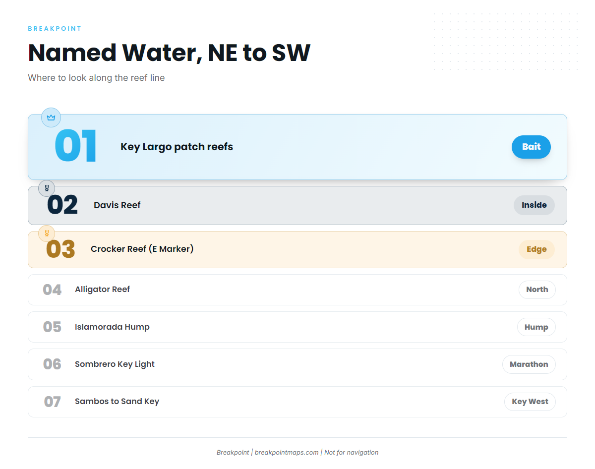
Sailfish work the outer reef edge and the drop outside it, where the Gulf Stream edge pushes onto the reef. The Chart Contours layer shows where the edge falls off.
Named water, northeast to southwest:
- Key Largo patch reefs, which hold bait
- Davis Reef, inside and southwest of the marker
- Crocker Reef, which locals call E Marker
- Just north of Alligator Light, at Alligator Reef
- Islamorada Hump
- The Sombrero Key Light area off Marathon
- The stretch from the Sambos to Sand Key, east of Key West
The pattern to look for is a color change. The Gulf Stream edge can park on the reef and draw a hard line between green and blue water, with bait-loaded green water meeting warm blue water within a short distance. Fronts push bait and sails down the reef line.
Finding the water
Three layers help you read it before you leave the dock:
- OBS SST shows the Gulf Stream edge pushing onto the reef.
- Chlorophyll shows the green-to-blue break.
- Chart Contours shows the edge itself.
Chart layers are not for navigation. Cloud blocks the satellite pass behind a front, which is when the bite fires. On those days, use the last clear pass and the buoys.
Season and the front cycle
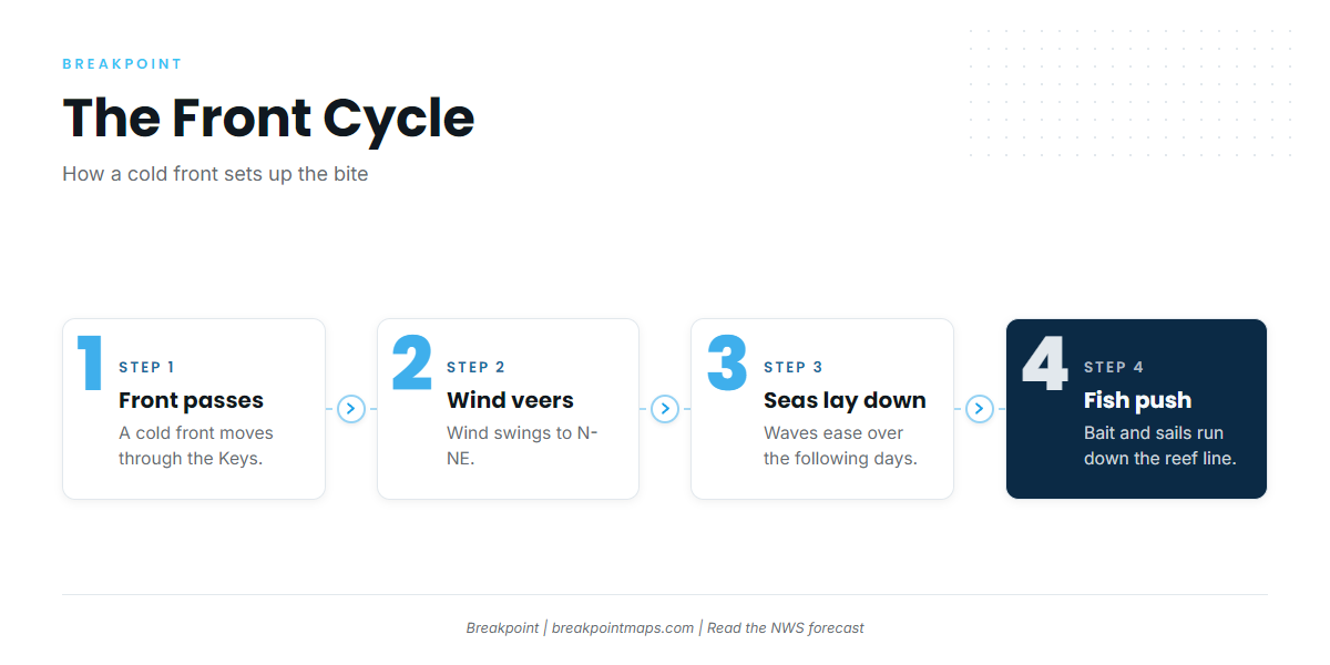
Fish show with consistency from November. The front-driven winter run follows, and fish linger into spring. The front sets the timing:
- A cold front passes.
- The wind veers to north and northeast.
- The seas lay down over the following days.
- Bait and sails push down the reef line.
Coast Pilot gives the wind climatology. Easterlies and northeasterlies are persistent, with trades usually 10 to 20 knots. Winds of 22 knots or more blow about 7 to 12 percent of the time from October through March. Hawk Channel is exposed at the large reef openings in southerly winds, principally between Alligator Reef Light and American Shoal Light.
Read the NWS Key West coastal waters forecast for wind in knots, wave height and dominant period. Check live observations at NDBC Sombrero and Sand Key. Forecasts miss, so treat the buoy readings as the final word on the day.
Winter tournament weekends crowd the Islamorada and Key West reef edge.
Tactics that suit the Keys
Boat pressure on the reef edge is steady in season, and live bait is the standard. Work the edge in the order below.
Bait first
Live ballyhoo hold on the reef inside Davis Reef, at Crocker Reef and just north of Alligator Light. Key Largo’s patch reefs also hold bait. Pilchards and goggle-eyes are the other live baits.
Do not anchor on coral while you bait. Use a mooring buoy.
Kite fishing in the trades
The persistent east and northeast trades suit kites. At 10 to 20 knots, they carry baits out from the boat while you set the drift along the outer reef edge with the current.
Kite work here differs from the Atlantic coast farther north. If you kite fish off Jupiter, see how that coast works. In the Keys the reef line sits about 5 miles out, and you work it after crossing Hawk Channel.
Slow-trolling live bait on light-wind days
When the wind is too light to fly a kite, slow-troll live bait along the edge and the color change.
Sight-casting to tailing fish after fronts
When north-northeast wind follows a front, fish can surf down the swells. Pitch live bait to visible fish. Use circle hooks with natural baits, and check NOAA HMS for the exact requirement.
Sanctuary water
The reef tract sits inside the Florida Keys National Marine Sanctuary. In Sanctuary Preservation Areas, anchors must not touch coral and discharges are restricted. Use mooring buoys.
The Looe Key Management Area lies about 6 miles south-southeast of Summerland Key. Fishing inside the Looe Key preservation areas is limited to catch-and-release trolling.
Zones change, so check them in the Marine Sanctuary Explorer app before you fish.
Frequently Asked Questions
Do I need an HMS permit to fish for sailfish off the Keys?
Yes, in federal waters, which include the reef edge. No HMS permit is needed for billfish in state waters inside 3 nm. A Florida saltwater license is required either way.
Is the reef edge state or federal water?
Federal. The state line is 3 nm, and Coast Pilot puts the reefs about 5 miles off the keys.
Can I lift a sailfish out of the water for a photo?
Not in federal waters. In state waters the same rule applies if your boat holds an HMS permit. Keep the fish in the water.
When do the sails show in the Keys?
Fish show with consistency from November. The front-driven winter run follows, and fish linger into spring.
Which ramp is closest for Alligator Reef?
Start with the Islamorada ramps on the FWC list: Founder’s Park, Plantation Key Boat Ramp, Harbor Lights at Holiday Isle and Indian Key Fill Boat Ramp. Channel Five lies about 8.4 miles west of Alligator Reef Light. Check the chart for your run.
Can a bay boat make the run to the reef edge?
The facts to weigh:
- The reef line is about 5 miles out.
- Trades usually blow 10 to 20 knots.
- Winds of 22 knots or more blow 7 to 12 percent of the time from October through March.
- Hawk Channel is exposed at the reef openings in southerly winds.
Read the NWS Key West coastal waters forecast for wind, wave height and period before you decide.
Where do I check conditions before I run?
Use the NWS Key West coastal waters forecast and the NDBC buoys at SMKF1 and SANF1. To plan the run to the edge, Breakpoint’s OBS SST, Chlorophyll and Chart Contours layers show the Gulf Stream edge, the color break and the drop. Download Breakpoint from the App Store or Google Play and see them for your port. Chart layers are not for navigation.