




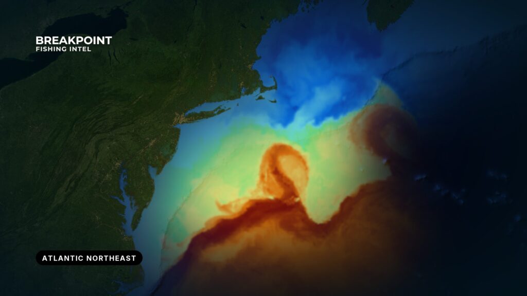
From Cape Hatteras to the Gulf of Maine, the bite sets up where moving water crosses shelf-edge structure. The canyons and banks stay in place while the water moves over them. This guide runs from Diamond Shoals to Hudson Canyon to Stellwagen and Georges Bank, and it is meant to help you decide where to look.
It covers:
- The ports, and the canyons each fleet runs to.
- How eddies and temperature breaks move across those canyons.
- When each fishery comes on, from the early offshore run to the fall.
- Which species or local guide to read next.
For other regions, see fishing guides by region.
If you fish inshore and are moving up, four terms carry most of what follows:
- Shelf edge / 100-fathom line: where the continental shelf drops toward deep water.
- Canyon: a cut in that edge.
- Eddy: a ring of Gulf Stream water that drifts over the shelf edge.
- Break: the line where two water types meet.
The coast by stretch and port
The coast runs south to north. Each stretch below gives the ports, the water they open to, the grounds the fleet runs to, and one note on navigation or conditions.
Cape Hatteras and Oregon Inlet: NDBC 41025 Diamond Shoals, NWS Newport/Morehead City
Hatteras Village sits on Hatteras Island and reaches the Atlantic through Hatteras Inlet and Pamlico Sound through Rollinson Channel. Oregon Inlet is at the north end of the island chain.
The Gulf Stream runs closest to the coast here. The fleet works the Point, the Rock Pile (a rocky ridge south of Cape Point), the 230 Rocks and the 280 Rocks, which puts wahoo, billfish and tuna within a short run. For one of those fisheries, see wahoo off Cape Hatteras.
Diamond Shoals need careful handling. According to NOAA Coast Pilot 4 guidance, the shoals extend about 9 miles southeast from Cape Hatteras, and the area is not charted for hydrography because it keeps changing. When your position is uncertain, stay in 120 feet of water, preferably 180. The same source says strangers should not attempt Rollinson Channel at night.
Hatteras Inlet is entered over a shifting bar, and its buoys are not charted. The Coast Guard port status lists frequent shoaling and shifting bottoms.
For wind, wave height and period, read the NWS Newport/Morehead City marine forecast. For observations at the shoals, use the NDBC 41025 Diamond Shoals buoy.
The Cape Hatteras National Seashore fishing page says the best fishing is in spring and fall, with mid-summer action best offshore.
Virginia Beach and the Eastern Shore: NWS Wakefield marine forecast
These boats run to Norfolk, Washington and Poorman’s Canyons, the southern end of the canyon chain and the first stops for warm water coming off the Stream. Check the NWS marine forecast for wind, wave height and period before the run.
Ocean City, Maryland: NWS marine forecast for the Delmarva coastal waters
Ocean City boats run to Poorman’s, Washington and Baltimore Canyons. It is a white marlin port. For details, see white marlin off Ocean City.
Cape May and the Jersey Shore: NWS Mount Holly marine forecast
Ports from Cape May north run to Wilmington, Spencer, Lindenkohl, Carteret and Toms Canyons. The northern Jersey ports reach Hudson Canyon. On the flats inside the canyons, fixed lobster gear holds mahi.
Montauk and Long Island: NWS Upton marine forecast
Offshore, Montauk boats reach Hudson Canyon to the west and Block and Atlantis Canyons to the east. Inshore, Montauk is a striped bass port. See striped bass off Montauk.
Rhode Island and Cape Cod: NWS Boston/Norton marine forecast
Cox Ledge sits inshore. Atlantis, Veatch, Hydrographer and Oceanographer Canyons lie offshore. The outer New England canyons border the Northeast Canyons and Seamounts Marine National Monument; the regulations section below points you to the agency.
Gulf of Maine: NDBC 44030 Western Maine Shelf, 44032 Central Maine Shelf, NWS Gray zone ANZ152
Ports here include Portland, Boothbay Harbor and Kennebunkport. The grounds are Stellwagen, Jeffreys Ledge, Platts Bank and Georges Bank. NOAA Fisheries says groundfish range from Cape Hatteras to the Canadian border and that most are landed in the Gulf of Maine and on Georges Bank.
Fog is the navigation concern. According to NOAA Coast Pilot 1, it occurs most often in summer. Winds from the east through south bring it in, and westerly and northerly winds clear it.
The banks here are bluefin country.
The canyons and banks
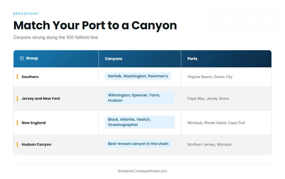
The canyons are cuts in the shelf edge, strung along the 100-fathom line from Norfolk to Oceanographer.
| Group | Canyons | Ports |
|---|---|---|
| Southern | Norfolk, Washington, Poorman’s, Baltimore | Virginia Beach and Eastern Shore; Ocean City |
| Jersey and New York | Wilmington, Spencer, Lindenkohl, Carteret, Toms, Hudson | Cape May and the Jersey Shore; northern Jersey and Montauk for Hudson |
| New England | Block, Atlantis, Veatch, Hydrographer, Oceanographer | Montauk, Rhode Island, Cape Cod |
Hudson Canyon is the best-known canyon in the chain. It is the main target for the Jersey and New York fleets and draws boats from well beyond its home ports. For how it fishes for tuna, see yellowfin in Hudson Canyon.
East-west position matters when you pick a canyon. Toward the eastern New England canyons, cold Gulf of Maine water meets Gulf Stream eddies, and the edges tend to run sharper. Farther west, shelf water coming off the shelf makes softer edges.
The banks and ledges:
- Georges Bank: the big offshore bank at the eastern edge of the Gulf of Maine.
- Stellwagen: the Gulf of Maine bank where bluefin collect.
- Jeffreys Ledge: a Gulf of Maine ledge fished from Maine and New Hampshire ports.
- Platts Bank: a Maine offshore bank, reached from Portland, Boothbay Harbor and Kennebunkport.
- Cox Ledge: the inshore ground off Rhode Island.
- The Point: the Hatteras ground nearest Cape Point.
- The Rock Pile: a rocky ridge south of Cape Point.
- The Big Rock: a Hatteras-area ground south of the main fleet’s grounds.
The banks are shallower shelf structure where bait and bluefin collect. The canyons are edge structure where blue water arrives.
What moves across them
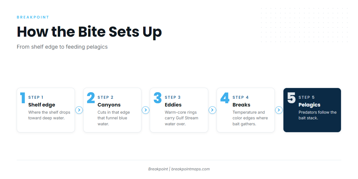
Start with the structure and work outward. The shelf edge holds the canyons. The Gulf Stream and its eddies bring warm water to them. Temperature and color breaks form where that water meets shelf water. Bait stacks on the break, and pelagics follow.
A warm-core eddy is a ring of Gulf Stream water that pinches off the north wall and drifts over the shelf edge, carrying blue water and bait toward the canyons. A temperature break is the line where two bodies of water at different temperatures meet at the surface, and bait gathers along it.
The north wall of the Stream wanders. The southern canyons see it first, and eddies carry it north and east.
Color shows the other half. Green shelf water meets blue water at a color edge. Chlorophyll shows the color side of the edge, and SST shows the temperature side. The first thing to look for is a hard edge over structure where the water goes from blue to green.
Cold water can also move the edge. When shelf or Gulf of Maine water pushes over a canyon and knocks the warm water off, the edge moves and the bite moves with it. A modest break that holds over a canyon wall for days builds more life than a sharp one that slides off overnight. Time on structure matters as much as the size of the break.
The data has limits:
- Cloud blocks satellite passes.
- SST reads only the skin of the water.
- Chlorophyll edges smear.
- A forecast is a forecast.
Plan the run on wind, wave height and period from the NWS marine forecasts and the NDBC buoys. For canyon fishing, read the period first, then the height.
Before you choose a canyon, check edge and eddy position on OBS SST and Chlorophyll over Chart Contours. Chart layers are not for navigation.
The season
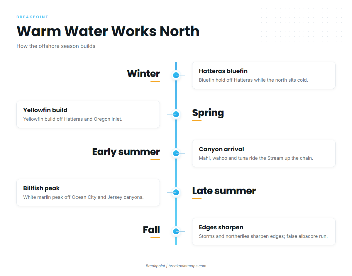
Warm water arrives in the south first and works north and east as the summer goes on.
The early offshore run
Hatteras carries bluefin in winter. Yellowfin build through spring off Hatteras and Oregon Inlet. White and blue marlin and mahi show by late spring. Start with Atlantic bluefin tuna and yellowfin tuna in the Northeast.
The summer canyon fishery
Warm water moves up the canyon chain in early summer, and mahi, wahoo and tuna arrive with the Stream. Most canyon trips are overnighters. Crews troll by day, and some drop for swordfish in the afternoon. They troll again at evening, then switch to overnight chunking for yellowfin and bigeye tuna.
Late summer is billfish time, with white marlin off Ocean City and the Jersey canyons. For the big fish, read about blue marlin. For the afternoon drop, see daytime swordfishing at the canyons.
Closer to the structure, mahi-mahi and wahoo in the Northeast work the warm edges. The Hatteras summer list is mahi, wahoo, blue and white marlin and sailfish.
The fall
Early fall storms and northerlies sharpen the edges at the canyons. Inshore, false albacore run the nearshore water from New England down to Hatteras. Bluefin work the Gulf of Maine banks and come back inshore along the coast. See fall bluefin on the banks.
Striped bass migrate south. For that run, see the striped bass migration guide. Hatteras closes the year with yellowfin, wahoo and returning bluefin.
Species and local guides
Before the run, check the water on OBS SST and Chlorophyll over Chart Contours. Every species covered is in the saltwater fish species guides. If you are moving up from inshore, start with the striped bass guide, then read bluefin.
Tunas
- Atlantic bluefin tunaThe Hatteras winter fishery to the Gulf of Maine banks.
- Bigeye tunaDeep-water tuna of the canyon edges and night chunk.
- Yellowfin tunaThe core canyon tuna, from spring off Hatteras to summer up the chain.
Billfish and swordfish
- Blue marlinBlue-water billfish where the Stream runs close.
- White marlinThe late-summer canyon billfish.
- SailfishThe warm-water edge of the region off Hatteras.
- SwordfishDaytime deep drops and night drifts at the canyons.
Mahi and wahoo
Inshore and coastal
- Striped bass – The spring and fall coastal migration.
Local guides
- Wahoo off Cape HatterasThe Point, the Rock Pile and the Stream off Hatteras.
- Yellowfin in Hudson CanyonHow the biggest canyon in the chain fishes for yellowfin.
- White marlin off Ocean CityThe Maryland canyons for white marlin.
- Striped bass off MontaukRips and the fall run at the east end of Long Island.
More guides
- Fishing guides by regionEvery region we cover.
- Saltwater fish species guidesEvery species guide in one place.
More species guides for the Atlantic Northeast: black sea bass in the Atlantic Northeast.