




A Newport albacore day depends on three decisions made in order: the bar, the run, and the edge. Your boat determines which of those you can afford to get wrong.
This is a local guide for anglers running their own boat out of Newport, Oregon. It skips albacore biology, tackle and spreads, including cedar plugs and clones, and covers the decisions specific to this port.
We give you the inputs; the call is yours. By the end you will have a bar plan, a method for setting range, a way to read the edge the night before and on the water, a private versus charter comparison, and the rules that apply.
Crossing the Yaquina Bay Bar
The Yaquina Bay entrance runs between the jetties to the Pacific. Every offshore trip from South Beach or the Bayfront crosses it twice, so the bar gets checked first.
These inputs matter:
- Tide stage. An ebb running against incoming swell steepens the bar.
- Swell. Check both height and period.
- Wind. Check speed and direction.
- Restriction status. Check USCG Station Yaquina Bay for bar restrictions.
Read wind, wave height and period from the NWS Portland marine forecast and the NDBC buoys, and compare the forecast to the buoy observations before you commit.
Timing the Return
Plan the return crossing before you leave the dock. The usual trap is a long run back that puts you at the bar late, on a building ebb, with afternoon wind up. Work backward from the tide table, set a latest-departure time from the fishing grounds, and hold to it.
Launch, Moorage and Fuel at South Beach
The Port of Newport recreational marina at South Beach monitors VHF 12, requires boats to be pre-registered, and assigns slips at the time of reservation. Fuel is listed, and the South Beach launch ramp is there too. The port’s page has South Beach recreational marina details.
The Bayfront is the commercial marina. Transient vessels check in at the port administration building before using port docks.
Fuel at South Beach the evening before, which leaves one less task at 4 a.m.
Bar Go/No-Go Checklist
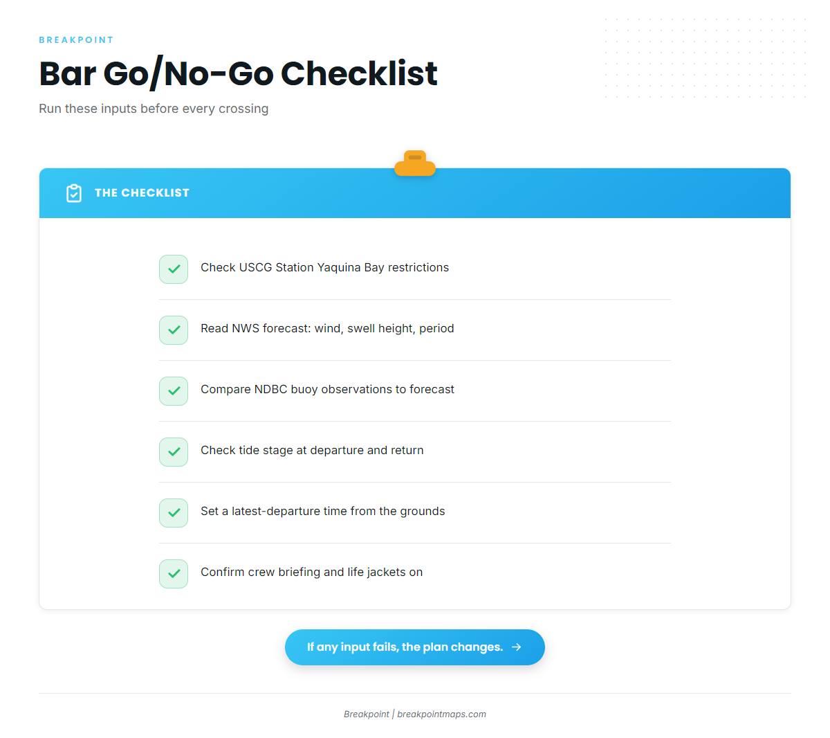
Run this list in order before you leave the dock:
- Check the USCG Station Yaquina Bay restriction status.
- Check the NWS marine forecast for wind, swell height and period, for both the outbound crossing and the return window.
- Check the buoy observations against the forecast.
- Check the tide stage at your departure and at your planned return.
- Set a latest-departure time from the grounds.
- Confirm the crew briefing and that life jackets are on for the crossing.
If any input does not support the plan, change the plan.
The Offshore Albacore Run
Range decides whether the trip happens. Albacore sit with warm, blue water, and where that water lies shifts from year to year and day to day with wind and upwelling. We print no distance figures, because the distance is whatever the water does that week. OBS SST shows where the warm water sits on a given pass. For the wider picture, see how the run sets up along the Oregon and Washington coast.
ODFW’s framing is plain: because of the distance from shore and the variable conditions, this fishery calls for specialized boating and safety equipment and good maritime knowledge. Check the ODFW Marine Zone fishing report for recent tuna reports before you go.
Fuel Planning
Fuel planning is a method, not a number we can give you:
- Know your boat’s burn at cruise and at trolling speed from your own logs.
- Plan the run out, the search time on the edge, and a return that may run into wind and swell.
- Set a fixed reserve rule before you leave the dock, and keep to it on the water.
Picking the edge before you leave cuts search miles, and that is where fuel is saved.
Safety Gear and Buddy Boats
For long runs, standard practice is:
- A buddy boat
- VHF with a set working channel and check-in times
- An EPIRB
- A liferaft
- A float plan left ashore
Stonewall Bank on the Way Out
ODFW lists the Stonewall Bank Yelloweye Rockfish Conservation Area at about 15 miles west of Newport. It is a common reference point on the run, and it is closed to bottomfish, long-leader and Pacific halibut fishing. A vessel with halibut aboard may transit but may not fish there. The ODFW Newport halibut grounds map shows the closed area.
Run Go/No-Go Checklist
Separate from the bar list, run this one before you commit to the range:
- Bar inputs pass.
- The edge has been located on recent OBS SST.
- Fuel covers the run, the search and the return into weather, plus your reserve.
- Your buddy boat is confirmed.
- Safety gear is checked.
- A float plan has been filed.
- The latest-departure time is set.
Reading the Warm-Water Edge
The edge is three waters in one place: cold green coastal water, warm water, and blue water. Bait concentrates where productive green water meets clean, warm water, so fish the change and stay on the warm, blue side.
Sharpness matters. A tight break bunches bait and fish, while a wide, gentle gradient spreads them out.
Watch for pinched-off warm blobs. Wind can cut a tongue of warm water off from the offshore mass. Fish inside it can be stranded, and the blob can hold fish or cool and go dead, so check whether it is still connected to the offshore mass.
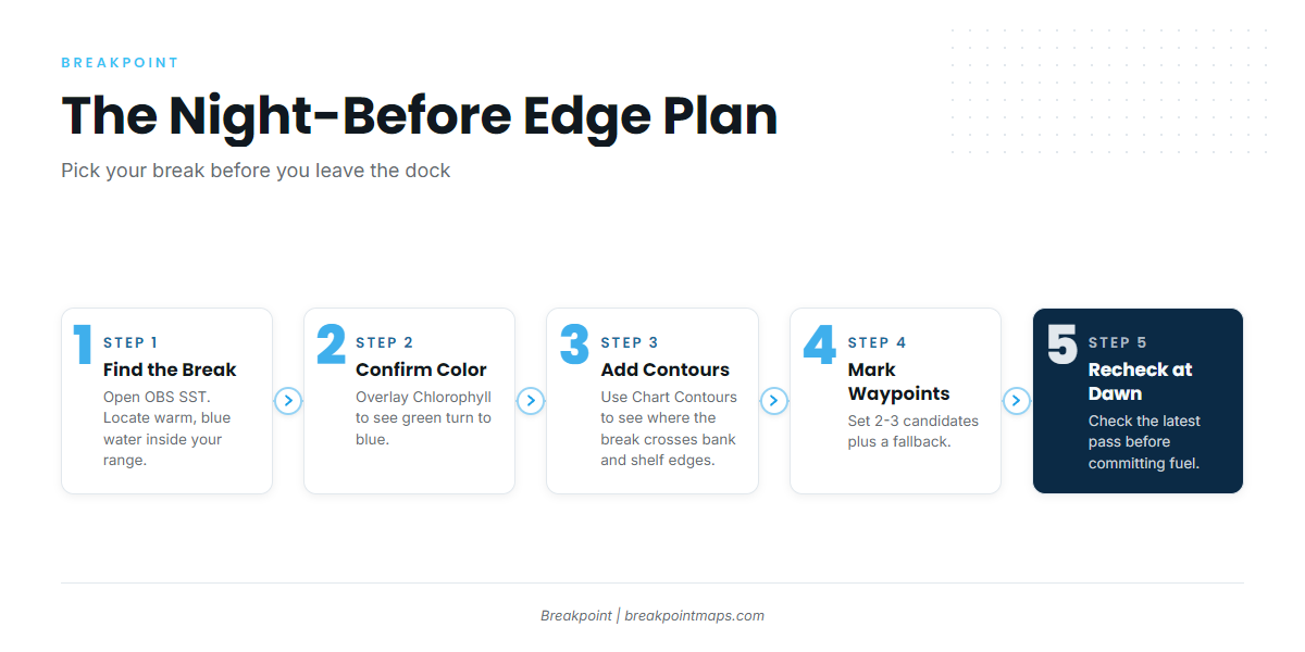
The Night-Before Edge Plan
- Open OBS SST and find the nearest break that puts warm, blue water inside your range.
- Overlay Chlorophyll to confirm the green-to-blue color change on the same line.
- Add Chart Contours to see where the break crosses bank and shelf edges.
- Mark 2 or 3 candidate waypoints, plus a fallback.
- Recheck the latest pass in the morning before you commit fuel.
Confirming on the Water
The water verifies the image. Look for:
- The temperature gauge stepping up
- A color change to blue
- Birds working
- Jumpers
- Bait on the sounder
- Slicks, foam lines and kelp paddies
When the gauge and the chart disagree, trust the gauge.
When to Commit and When to Move
Work the warm side of the break, and move along the edge rather than across it. Leave water that shows no life after a fair pass, and let birds redirect the search.
What the Data Cannot See
Cloud blocks satellite passes. A composite image blends several past days, and an edge moves between the image and your arrival. Satellite data reads the surface only.
Putting the Layers to Work
The workflow is OBS SST plus Chlorophyll to pick the break the night before, rechecked in the morning, with Chart Contours for bank and shelf edges. Chart layers are not for navigation. They help you decide where to look.
Private Boat vs. Charter
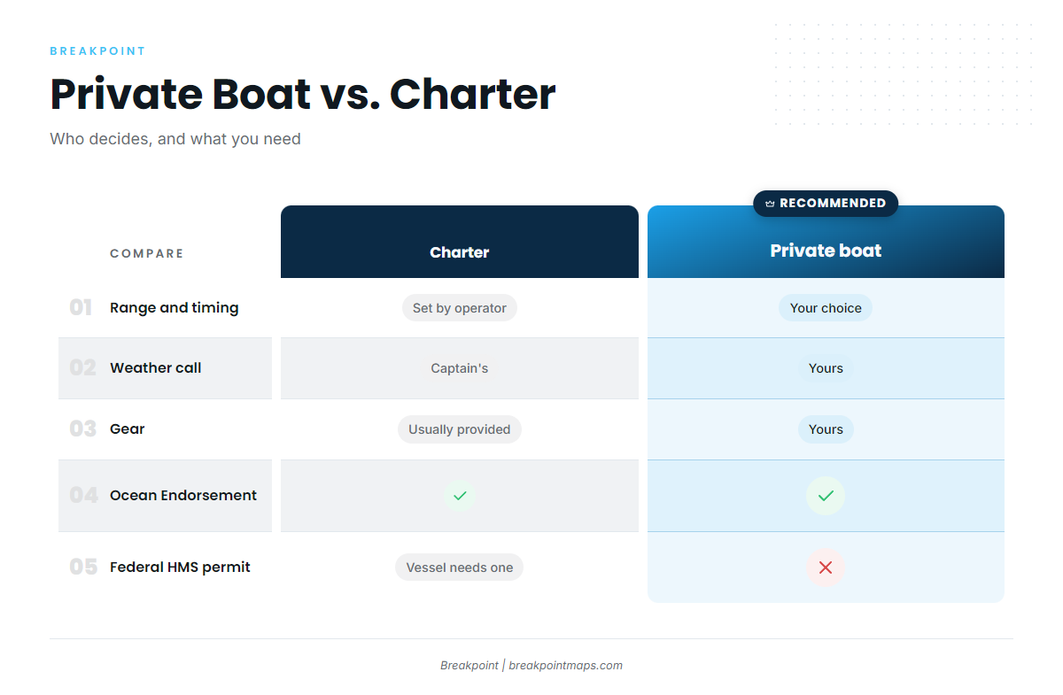
The choice comes down to range, judgment and what you already own.
| Factor | Private boat | Charter |
|---|---|---|
| Range and flexibility | You choose where and when you run | Set by the operator |
| Weather call | Yours | The captain’s |
| Gear | Yours | Usually provided |
| Licensing | Ocean Endorsement when tuna is kept | Ocean Endorsement when tuna is kept |
| Federal HMS permit | Not required | Vessel must hold one |
| Cost structure | Fuel, gear and wear | Per seat or whole boat |
| Who it suits | A capable owner with an offshore-ready boat | First-timers, or anglers without a range-ready boat |
A charter first is a sound way to see the run before you take your own boat out. You learn the bar timing, the distance and the handling without carrying the whole decision.
Catch handling is the same on either boat. Bleed and ice the catch. ODFW’s partial-cleaning rule applies on both: albacore may be cleaned at sea of head and entrails only, with the collar and tail left on.
If you trailer in for salmon and bottomfish too, the other Pacific Northwest fisheries out of Newport run on the same bar and weather logic.
Whoever runs the boat, a fresh look at OBS SST before the trip makes for a better decision about where to look.
FAQ
How far offshore are albacore from Newport?
It varies with where the warm water sits, from year to year and day to day. Check OBS SST for the current position of the warm, blue water. Nearby ports such as Depoe Bay and Charleston face the same variable, so the distance is a question for the chart, not a fixed number.
When do albacore show off Newport?
Albacore are a summer and autumn fish at Newport, per the port’s species calendar. Dates shift with the water, so we give none. Check the ODFW Marine Zone fishing report for recent tuna reports before you plan a trip.
Do I need a special license for albacore in Oregon?
Yes. You need the Ocean Endorsement when tuna is kept, on a private boat or a charter. Confirm the full license requirements with ODFW before you fish.
What is the albacore limit off Oregon?
ODFW sets 25 offshore pelagic fish per angler per day in aggregate. The federal limit is 25 albacore per angler north of Point Conception, which covers Oregon. Check ODFW before fishing for any change.
Can I fish Stonewall Bank on a tuna trip?
The Stonewall Bank Yelloweye Rockfish Conservation Area is closed to bottomfish, long-leader and Pacific halibut fishing. A boat with halibut aboard may transit but may not fish there. Check the ODFW Newport halibut map for the boundaries.
Can I fish tuna with a salmon aboard?
Yes. With a salmon aboard, you fish any species with no more than 2 single-point barbless hooks and one line per angler. That limits your albacore gear while the salmon is on the boat.
Does a private boat need an HMS permit?
No. The federal HMS permit applies to charter and commercial vessels. A private recreational boat does not need one. The albacore limit and the Ocean Endorsement still apply.
Conclusion
The order stays the same: the bar, then the range, then the edge. The bar sets whether you leave, the range sets how far you can afford to go, and the edge sets where you look.
Three actions carry the day:
- Check the bar inputs and set your latest-departure time.
- Pick the edge the night before on OBS SST and Chlorophyll.
- Recheck in the morning before you commit fuel.
The water and the forecast have the last word, and chart layers are not for navigation.
If you want that night-before read in one place, download Breakpoint from the App Store or Google Play and see how the layers line up for your run out of Newport.