




San Diego puts deep water, offshore banks, islands and a Mexican-water option within reach of a private boat, and the port has a live-bait tradition behind it. That is why Pacific bluefin tuna fishing off San Diego draws private-boat owners from across the Southwest. Biology, tackle and technique are in our Pacific bluefin tuna guide.
This page covers where San Diego boats run, what the water has to show before a ground is worth the fuel, and how a private boat’s call differs from a party boat’s. We can’t promise fish, but we can help you decide where to look.
Why San Diego is a bluefin port
San Diego Bay reaches the Pacific through one dredged entrance between Point Loma and North Island. From there, the Point Loma kelp beds, the nearshore banks and the Coronado Islands (Islas Coronado, in Mexican waters) are a short run away. San Clemente Island and the outer banks lie farther out. Bluefin show within reach of San Diego for much of the year.
How fish move along Southern California and northern Baja, and how the northern ports fit in, is in our Southern California and Baja bluefin guide. Here we keep to San Diego.
Four things shape the port’s bluefin fishing:
- One entrance, short runs. Every boat leaves through the same channel, and the first grounds are close.
- Mexican water next door. The Coronado Islands sit just across the line.
- Bait on the dock. Live bait receivers supply the fleet and private boats alike.
- A working fleet. Landings boats are on the water, and their reports circulate through the port.
Getting out of San Diego Bay
Trailer boats have four public options on the bay: Shelter Island, Chula Vista (J Street Marina Park), National City (Pepper Park) and Glorietta Bay in Coronado. The Port of San Diego launch ramps page has details. For fuel, Harbor Island West Marina lists it.
The entrance calls for caution. Per the NOAA Coast Pilot 7 Chapter 4, watch for these:
- Currents near the entrance usually run 0.5 to 5 knots with the tide and follow the channels.
- A slight set runs toward Zuñiga Shoal on the ebb, and a crosscurrent off Ballast Point can cause a sudden sheer.
- A submerged jetty runs 1 mile south from Zuñiga Point. Its outer two-thirds shows only in small sections at high water.
- The ship channels are designated narrow channels. Vessels under 20 meters (65.6 feet) and vessels engaged in fishing must not impede vessels confined to the channel. The bay is also a Navy base with cruise and cargo traffic.
- Radiation fog is common from September through April, with December the foggiest month. It is worst late at night and in early morning, and heavier at the entrance.
Read wind, wave height and period on the NWS San Diego coastal waters forecast. NDBC 46232, the Point Loma South waverider, gives measured numbers offshore of the entrance.
Where San Diego boats run
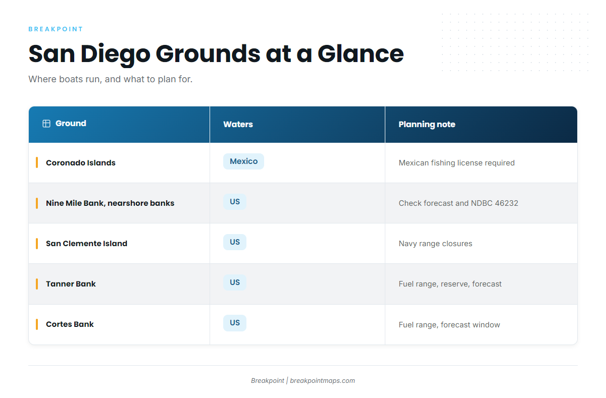
These are the grounds boats run from San Diego. Whether any is worth the fuel depends on the water, which the next section covers.
| Ground | Waters | What makes it fish | Planning notes |
|---|---|---|---|
| Coronado Islands (Islas Coronado) | Mexico | Island shelf and edges where breaks and bait can stall close to port | A Mexican fishing license is required to fish Mexican waters, including the Coronados. See Regulations. |
| Nine Mile Bank and the nearshore banks (local spots called the 302, 371 and 425) | US | Bank edges and steep contours that can hold a break near port | Shortest offshore run. Check the forecast and NDBC 46232. |
| San Clemente Island | US | Island shelf and edges | The waters are part of a Navy range with scheduled closures. Check the Navy San Clemente Island range schedule and the Coast Guard Local Notice to Mariners. |
| Tanner Bank | US | Remote bank structure rising from deep water | Fuel range, return reserve and forecast numbers decide it. |
| Cortes (Cortez) Bank | US | Remote bank structure | Same as Tanner. Plan around fuel range and the forecast window. |
The 302, 371 and 425 are local spot names. Look them up on Chart Contours rather than trusting a number someone read off a radio.
The outer banks need a forecast window and a fuel plan. Keep a reserve for the run home.
The same grounds also hold yellowtail, dorado and albacore, and Mission Bay, Oceanside and Dana Point boats work much of this water. Our Southern California fishing guide covers those ports and species.
Reading the water off San Diego
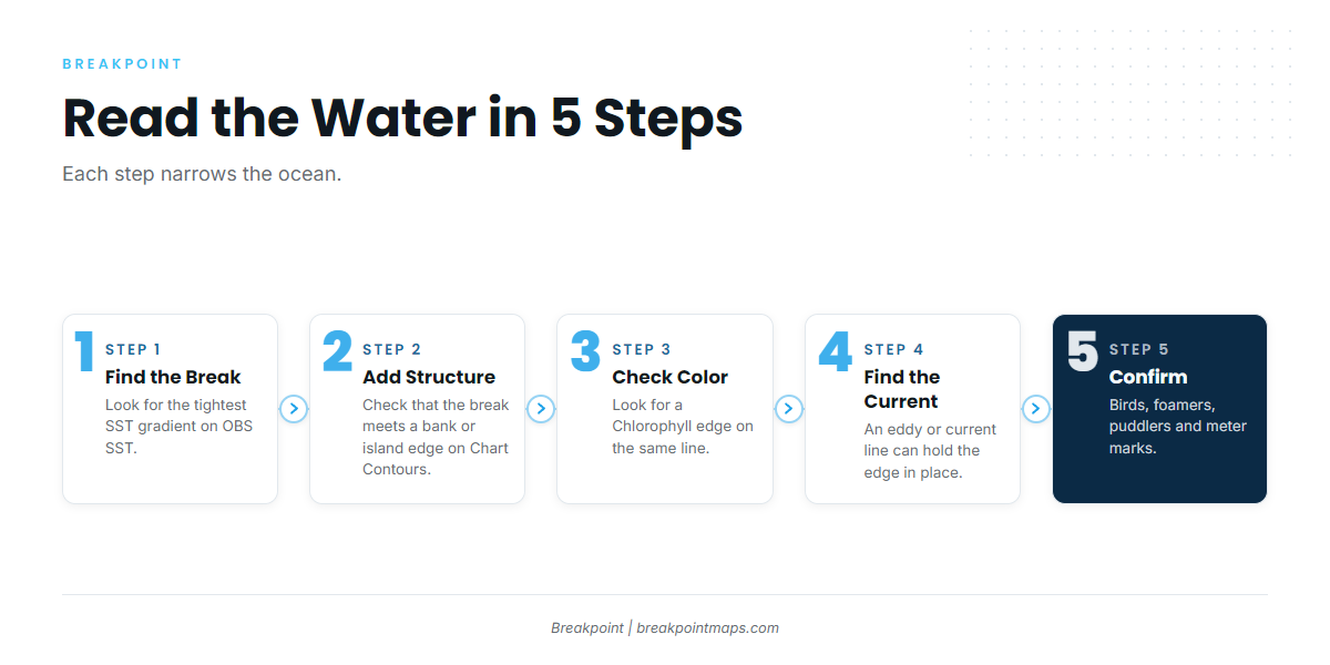
The order matters. Each step narrows the ocean: break, structure, color, eddy or current, then confirmation on the water.
A tight break bending around the edge of a bank, with green water on one side, is the shape to look for. That example is hypothetical, not a report. What you want is a gradient, structure under it, and a color edge on the same line.
Temperature breaks
A break is a tight SST gradient where two water masses meet. Look for the tightest gradient rather than a target temperature. A break that touches a bank edge or island shelf matters more than one in open water, because structure holds bait and slows the edge.
Put OBS SST over Chart Contours to see where the two meet.
Chlorophyll
A color edge on the same line as the temperature break strengthens the case. Green water beside blue water marks where bait and plankton collect. Chlorophyll has limits: cloud affects it, and coastal water skews readings near shore.
Eddies and upwelling
An eddy or current line can hold an edge in place over several passes. Upwelling followed by a few settling days tends to produce edges.
Confirm on the water. Birds, foamers, puddlers and meter marks tell you the edge is holding fish. Kite and flying fish tactics come after you find them, and the species guide covers technique.
What the data can’t see
- Cloud blocks infrared SST passes and leaves gaps.
- A single pass is sharp but may be partial. A composite fills gaps but smooths and ages the edge.
- Surface data cannot see a thermocline or fish depth.
- Fleet reports describe yesterday.
Chart layers are not for navigation.
The checklist
- A tight break.
- The break meets a bank or island edge on Chart Contours.
- A Chlorophyll edge on the same line.
- An eddy or current line holding it.
- Birds, foamers, puddlers and meter marks to confirm.
Open OBS SST, find the tightest gradient near a bank on Chart Contours, then check Chlorophyll for a color edge on the same line.
Private boat or party boat
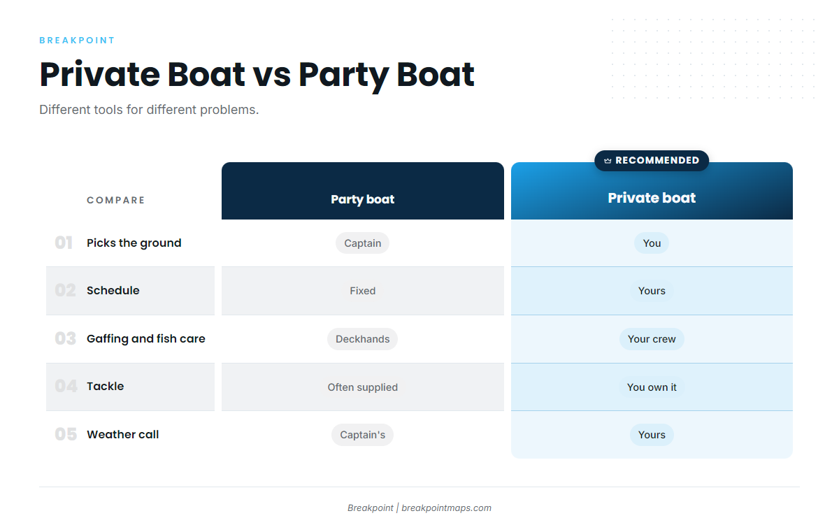
Neither option is better in general. They solve different problems.
| Factor | Private boat | Party boat |
|---|---|---|
| Who picks the ground | You do | The captain does |
| Schedule | Yours | Fixed |
| Gaffing and fish care | Your own crew | A deckhand crew |
| Tackle | Owned and maintained by you | Supplied or rentable on many trips |
| Landing a big fish with a small crew | The wiring, gaffing and space all fall on your boat | A crew handles it |
| Weather call | Yours, using the forecast numbers | The captain’s |
A private boat demands seamanship, fuel planning and a crew who know their jobs on a big fish. A party boat is a way to learn the grounds and fish handling.
The private boat’s advantage is choosing the ground, and that choice gets made by reading the water.
FAQ
Do I need a Mexican fishing license to fish the Coronado Islands?
Yes. The Coronados are in Mexican waters. CONAPESCA handles fishing licenses, and INM handles the FMM. Check both agencies before you go, since requirements and procedures are theirs to set.
What is the bluefin bag limit off California?
The bag is 2 per person per day under 14 CCR 28.38, in addition to the 20-finfish limit, and it applies to bluefin possessed wherever taken. The federal bag is also 2 if any part of the trip is in the EEZ.
Does a private boat need a federal HMS permit?
The NOAA Fisheries HMS permit requirement names commercial and charter vessels, not private recreational boats. That is how the rule reads today. Confirm with NOAA Fisheries before you go, since permit rules are theirs to interpret.
Can a small boat reach Tanner and Cortes Banks?
Fuel range, a return reserve and the forecast numbers decide it. Read wind, wave height and period on the NWS coastal waters forecast and NDBC 46232. If the numbers or your fuel plan don’t hold up, the banks can wait.
Are there closures at San Clemente Island?
Yes. The waters are part of a Navy range with scheduled closures. Check the Navy San Clemente Island range schedule and the Coast Guard Local Notice to Mariners before you fish there.
How do I fillet bluefin legally south of Point Conception?
Bag each tuna individually and mark the bag with the species’ common name. Cut the fish into 6 skin-on pieces: 4 loins, the collar as 1 piece with both pectoral fins attached, and the belly with the vent and both pelvic fins attached.
Which SST layer should I start with?
Start with OBS SST and look for the tightest gradient. Lay Chart Contours over it for structure, then check Chlorophyll for a color edge on the same line. Cloud gaps are possible, so read what the layer cannot see.
Can I use the chart for navigation?
No. Chart layers are not for navigation. Use official nautical charts and the Coast Pilot.