




Not for navigation. Breakpoint charts are for trip planning. Navigate with official charts and your vessel’s instruments.
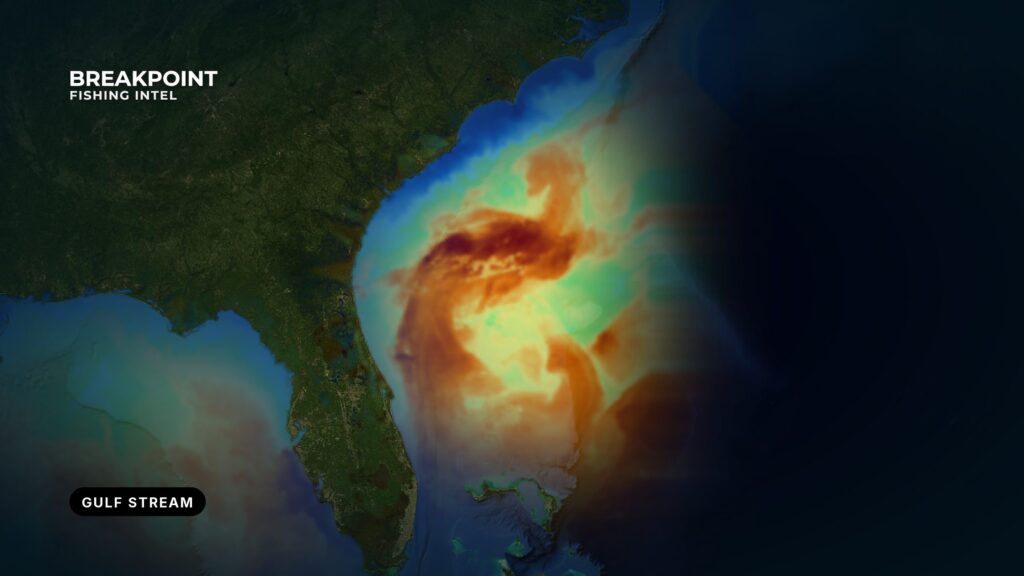
The Gulf Stream inshore edge, or western wall, is the boundary where green shelf water meets warm blue Stream water. Temperature, color and current change across it. It moves with meanders, eddies and wind, so its position has to be read on the day rather than taken from last week’s numbers.
Introduction
Say you’re planning a long run the night before, and the free SST image you pulled has a cloud hole right where the wall should be. This method is for that situation. Reading the Gulf Stream inshore edge means reading the layers first, then confirming on the water.
This page gives no spots and promises no fish. It gives you a way to decide where to look. The starting point from NOAA is that the Stream’s average inner edge from the Straits of Florida to Cape Hatteras lies inside the 100-fathom curve. That is an average, not today’s position.
We cover what the edge is, why it moves, how OBS SST, Chlorophyll and current layers show it, what the data cannot see, how to confirm it from the boat, and how Atlantic ports use it.
What the Inshore Edge Is
The western wall is where cooler, greener shelf water meets warm, blue, fast Stream water. Temperature, color, bait, weed and current speed can all change across it. It is one kind of water-mass boundary, the same family you learn when reading ocean water for fishing.
The inshore edge is a single line only on a coarse map. It is made up of several fronts, overlapping like shingles from the Florida Straits past Cape Hatteras, so expect more than one break on a run.
NOAA’s U.S. Coast Pilot 5 says the wall is most clearly marked north of Cape Hatteras and less well defined from the Straits of Florida to Hatteras. Between Fowey Rocks and Jupiter Inlet, the inner edge lies very close to the shoreline. The segment off South Florida is called the Florida Current.
Breakpoint layers are for fishing decisions, not for navigation. Use official NOAA charts to navigate.
Edge, core and offshore side
- The edge is a gradient and a shear zone, and it is where bait gathers.
- The core is fast and uniform.
- The offshore side is a different boundary.
A sharp edge with bait is worth more than a diffuse edge with no life.
Short glossary
- Western wall: the inshore boundary of the Stream, where shelf water meets Stream water.
- Florida Current: the name for the Stream off South Florida.
- Meander: a swing of the Stream toward or away from the shelf.
- Frontal eddy: a small spinning feature that forms along the inshore edge.
- Filament: a thin tongue of warm or cool water drawn off the edge.
- Warm-core ring: a detached piece of the Stream that drifts away from the main flow.
- Shear: a sharp change in current speed or direction across a short distance.
- Convergence: where two water masses meet and push together, often collecting weed and bait.
Why the Edge Moves
The Stream is a moving river of water, shaped by features both large and small. Each driver below changes where blue water sits relative to the shelf.
Meanders
The Stream swings toward and away from the shelf. A warm finger pushing toward the shelf brings blue water within range, and a swing away pulls it out of range.
Frontal eddies and filaments
Smaller features peel off the inshore edge and pull warm water over the shelf. Read their edges rather than their centers.
Warm-core rings
Detached pieces of the Stream carry edge-like conditions north toward the mid-Atlantic canyons.
Wind
Wind pushes surface water and weed lines, so the surface edge can sit apart from the deeper front. Wind against current steepens seas at the edge. Check the NWS marine forecast and NDBC buoys for wind, wave height and period before you decide.
Charleston Bump and Cape Hatteras
The bottom rise off the Carolinas and Georgia deflects the Stream and helps spin up eddies downstream. At Hatteras the Stream leaves the shelf, and north of it the wall is most clearly marked.
Persistence
Boundaries that hold in one area for several days tend to concentrate bait better than a front that just arrived. A fresh edge can be real, but a settled one has had time to stack life along it. Last week’s position is history, so read the edge again on the day.
Reading the Layers
No single layer is the answer. Trust the edge when the layers agree.
Breakpoint layers are for fishing decisions, not for navigation. Use official NOAA charts to navigate.
Reading SST on the Edge
Tight color banding on OBS SST is the wall. Look for gradients rather than single numbers. For the full method, see how to read a temperature break on an SST map.
Satellites such as VIIRS and MODIS supply the SST and color imagery. Parallel bands mean multiple fronts, the shingle pattern described earlier.
Color: Blue Versus Green
The Chlorophyll layer shows green, productive shelf water against clear blue Stream water. It helps when SST is flat, as in summer, or ambiguous. For more, see chlorophyll and water color maps.
A big green area is not the target; the color edge is.
Current: Direction, Speed and Shear
Current arrows show where the Stream runs and where speed changes sharply. That change is shear, and shear often sits on the wall. Modeled current is a forecast, so calibrate it against your boat’s drift.
Chart Contours: Where the Edge Meets Bottom
Use Chart Contours to see where the edge crosses the shelf break and ledges. That is the 100-fathom context. Chart Contours are for fishing decisions, not for navigation. Use official NOAA charts to navigate.
Overlaying Layers and Resolving Conflicts
When an SST break, a color break and a current shear line up, you have a high-confidence edge. When they disagree, look harder.
- SST is sharp but color is flat. Possible cause: a surface skim or a stale color pass.
- Color shifted but there is no SST break. Possible causes: a cloud-masked SST pass, or a river plume or inshore boundary unrelated to the Stream.
- Current disagrees with both. Possible cause: model lag.
Fish the rim of an eddy, not its center. Inshore boundaries may have no relation to the Stream at all, and they should be judged on their own merits.
What each layer shows
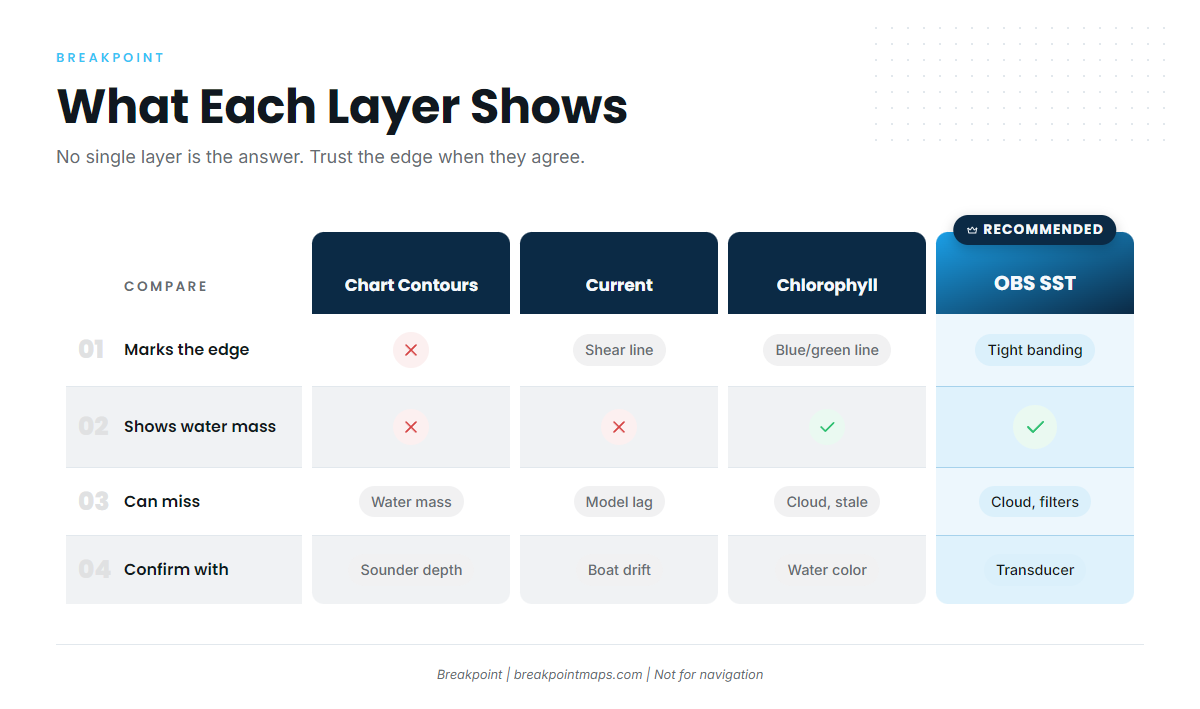
| Layer | What it shows on the edge | What it misses | How to confirm on the water |
|---|---|---|---|
| OBS SST | Tight banding marks the wall | Gaps under cloud; filters can drop fast edges | Transducer temperature jump |
| Chlorophyll | Blue versus green boundary | Gaps under cloud, stale passes, plumes that mimic edges | Watch the water color change |
| Current | Direction and shear | It is a model and can lag a meander | Boat drift versus the arrows |
| Chart Contours | Bottom context | Nothing about water mass | Depth on the sounder |
Breakpoint layers are for fishing decisions, not for navigation. Use official NOAA charts to navigate.
What the Data Cannot See
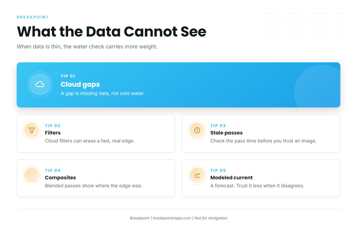
Every layer has blind spots, and it helps to know them before trusting the image.
- Cloud-masked pass. A gap is missing data, not cold water.
- Filtering that deletes a fast edge. Cloud filters can flag a sudden, real temperature change as cloud and remove it, right on a moving wall.
- Stale passes. Check the pass time before you trust an image.
- Composites. Multi-day composites fill gaps by blending old and new passes, so the edge you see may be a blend of where it was.
- Modeled current. It is a forecast. Trust it less where it disagrees with observations.
When the data is thin, the on-the-water check carries more weight.
Breakpoint layers are for fishing decisions, not for navigation. Use official NOAA charts to navigate.
Confirming the Edge on the Water
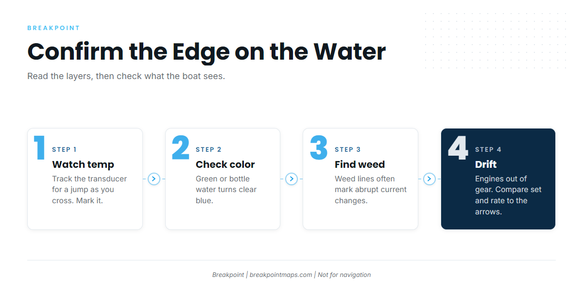
The layers tell you where to look, and the boat tells you what is there.
- Transducer temperature. Watch for a jump as you cross, and mark where it happened. This is the same signal behind reading temperature breaks on a map.
- Color change. Green or bottle-colored water goes to clear blue. Sometimes there is a visible line.
- Weed lines and rips. Weed lines along the inshore edge often mark abrupt changes in current velocity. Several lines can run along the edge, and sargassum collects where water converges.
- Birds and bait. Treat them as supporting signs, not proof.
- Boat drift against the model. Drift with the engines out of gear. Compare your set and rate to the current arrows, and use the difference to judge how far to trust the model that day.
How Atlantic Ports Use the Edge
These notes describe how each area relates to the Stream, not where the edge is today. Read the official NWS marine forecast and NDBC observations for wind, wave height and period before you decide.
Breakpoint layers are for fishing decisions, not for navigation. Use official NOAA charts to navigate.
South Florida: Hillsboro Inlet and Port Everglades
Between Fowey Rocks and Jupiter Inlet the inner edge lies very close to shore, which makes for close-in runs. Hillsboro Inlet is described as a base for party boats that run into the Gulf Stream.
Easterly trades along this coast average 10 to 15 knots, per Coast Pilot 4, Chapter 10. Winds of 17 knots or more are most frequent September through April. That is the classic setup for wind against a north-setting current, which steepens seas at the edge.
Anglers commonly target sailfish, mahi-mahi, wahoo and blackfin tuna out of these ports. Read conditions on NWS zone AMZ651 and at NDBC station PEGF1 observations. NDBC station LKWF1 at Lake Worth Pier covers the area to the north.
The Carolinas: Sneads Ferry and Morehead City
The run crosses Onslow Bay to the Stream, and its length depends on where the edge sits that day. The Charleston Bump, upstream, shapes the eddies that arrive here.
Mahi-mahi are common in summer and wahoo in autumn. For forecasts, use the NWS Newport/Morehead City marine zones: AMZ158 out to 20 nm and AMZ188 from 20 to 60 nm. Check the edge the night before so you aren’t making a blind run.
Virginia Beach and the Canyons
The Stream’s influence reaches Norfolk Canyon mainly through warm-core eddies and intrusions rather than the main wall, so read eddy edges. Summer targets include yellowfin tuna, white marlin, blue marlin and mahi-mahi. For conditions, use the NWS Wakefield marine forecasts for the 20 nm and 20 to 60 nm zones.
Port approach at a glance
| Port | Inlet | How the Stream reaches it | Where to read conditions |
|---|---|---|---|
| Pompano Beach | Hillsboro Inlet | Main wall close inshore | NDBC LKWF1 |
| Fort Lauderdale | Port Everglades Inlet | Main wall close inshore | AMZ651, NDBC PEGF1 |
| Sneads Ferry / Morehead City | New River Inlet / Beaufort Inlet | Across Onslow Bay to the wall | AMZ158, AMZ188 |
| Virginia Beach | Rudee Inlet | Eddies and intrusions toward Norfolk Canyon | NWS Wakefield 20 nm and 20 to 60 nm zones |
Breakpoint layers are for fishing decisions, not for navigation. Use official NOAA charts to navigate.
A Check-on-the-Day Workflow

Run this in order. The night before:
- Open OBS SST and find the tightest banding along your side of the Stream.
- Open Chlorophyll and look for a matching blue and green line.
- Check current arrows for shear on the same line.
- Note the pass times. Treat gaps and composites as unknowns.
- Read the NWS marine forecast for your zone: wind, wave height and period.
At the dock:
- Re-open the layers for a newer pass. Re-check the forecast and NDBC observations.
- Pick a primary line and a backup line. Use Chart Contours for bottom context.
On the run:
- Watch the transducer for the temperature jump. Mark it.
- Confirm color, weed lines and birds.
- Drift and compare against the current arrows. Adjust.
Open OBS SST, Chlorophyll and Chart Contours in Breakpoint the night before and again at the dock. Breakpoint layers are for fishing decisions, not for navigation. Use official NOAA charts to navigate.
Frequently Asked Questions
What is the Gulf Stream inshore edge?
It is the western wall: the boundary between shelf water and Stream water, made of a series of fronts rather than one line. Temperature, color and current change across it. It moves, so check it on the day.
Why does the edge move?
Meanders swing the Stream toward and away from the shelf. Frontal eddies, filaments and warm-core rings peel off and carry edge conditions with them. Wind shifts the surface edge, and bottom features such as the Charleston Bump deflect the flow.
Why does SST show a gap at the edge?
Cloud masks the pass, and filters can remove a fast, real change by flagging it as cloud. Passes can also be stale. Cross-check with Chlorophyll and current, then confirm with your transducer.
What is blue water versus green water?
Blue is clear, warm Stream water. Green is productive shelf water. The line between them is the target, not the middle of either.
Where does the Stream run closest to shore?
Between Fowey Rocks and Jupiter Inlet, the inner edge lies very close to the shoreline, according to the Coast Pilot. That describes an average position, not today’s.
What does not-for-navigation mean?
Fishing layers support where-to-fish decisions. Navigate with official NOAA charts and publications.
Close
The inshore edge is a boundary between water masses, and it moves. Read the layers, trust them when they agree, and confirm on the water. The Coast Pilot gives an average position, and the day’s layers show where the edge actually sits.
That gives you a better basis for deciding where to look, which is as much as any data can offer. Check the inshore edge on the day, every day you go.
Check OBS SST, Chlorophyll and Chart Contours for your port in Breakpoint before the next run. Breakpoint layers are for fishing decisions, not for navigation. Use official NOAA charts to navigate.