Swordfish fishing out of Belmar
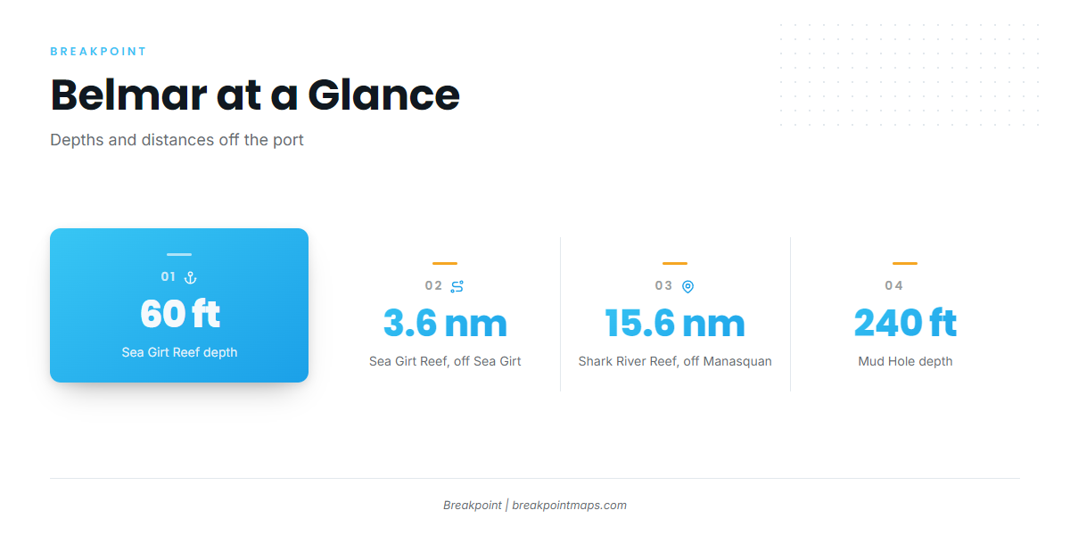
Swordfish fishing out of Belmar starts at Shark River Inlet, and the named bottom off this stretch runs from 60 ft to 240 ft. This page covers the structure by name, depths and distances as numbers, the method boats use, and who runs it.
The port
Boats leave from Belmar and Shark River Inlet. Manasquan Inlet sits just north and serves as the reference point for some of the distances below. The page assumes you read charts and run your own boat, so it skips the basics.
When the fish are around
Seasonal timing and swordfish biology are covered in the swordfish species guide. The regional run and the canyon picture are in swordfish in the Atlantic Northeast (see also the Atlantic Northeast fishing guide). What follows stays with what is specific to Belmar: where the bottom is, how far you run to reach it, and who fishes it.
How far boats run
Distances here are measured from the reference points the data gives us, not from the inlet.
The inshore stops
Sea Girt Reef sits 3.6 nautical miles off Sea Girt, in 60 to 75 ft. Shark River Reef sits 15.6 nautical miles off Manasquan, in 125 ft. Local boats run past this bottom and fish it on combo trips. These are not swordfish depths, so treat them as the first stops on the way out.
The Mud Hole edge
The Mud Hole bottoms out at 240 ft. Its edge is the reference point for the deeper wrecks in the next section, so plot it first. No distance is given for it here.
Before any run, read wind, wave height and period as numbers from the official NWS marine forecast for your zone.
Grounds and structure off Belmar
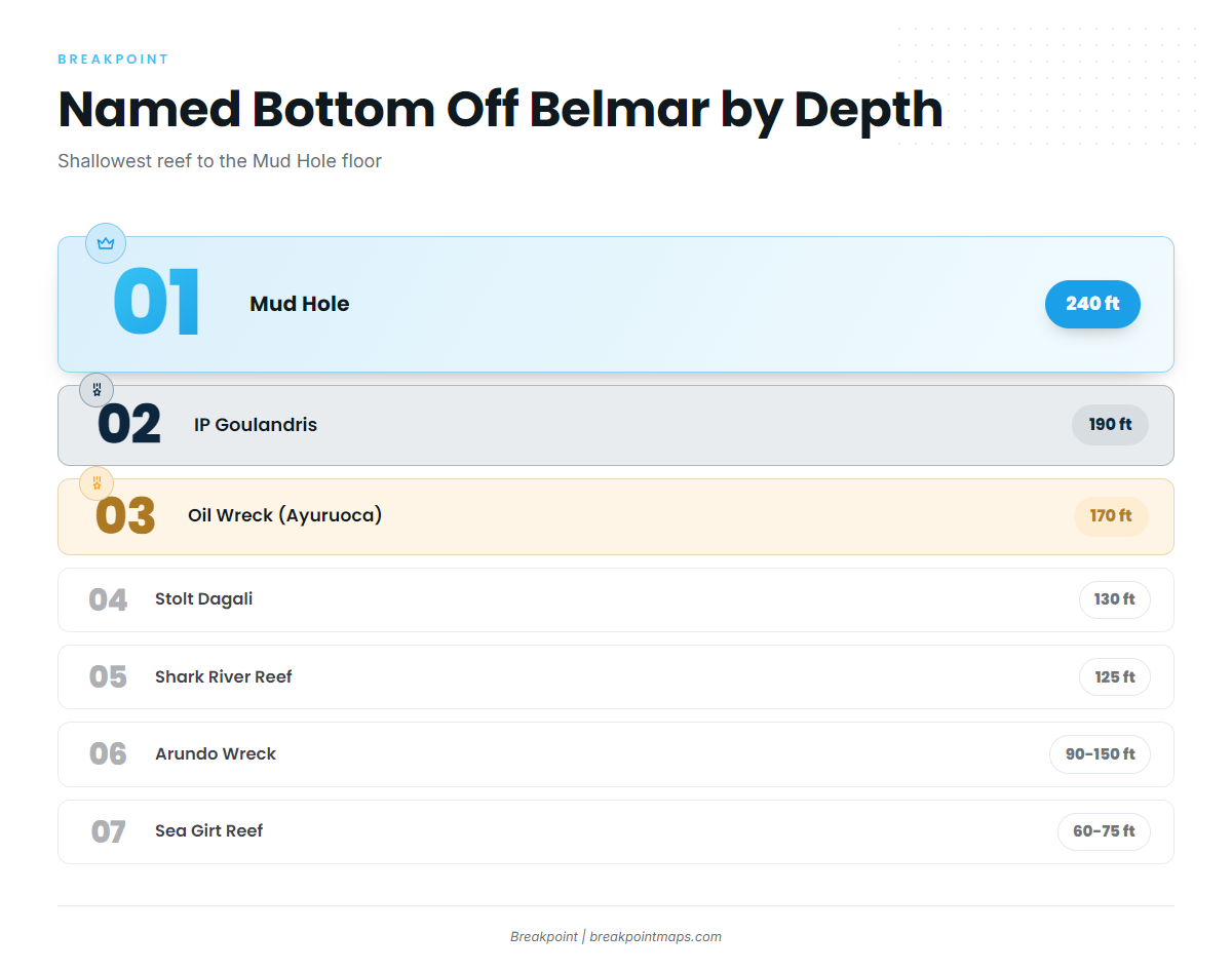
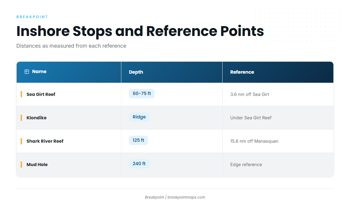
The named bottom runs from 60 ft to 240 ft. The table lists it in rough order of distance from the beach.
| Name | Depth (ft) | Location reference |
|---|---|---|
| Sea Girt Reef | 60 to 75 | 3.6 nm off Sea Girt, atop the Klondike ridge |
| Klondike | Under Sea Girt Reef | Underwater ridge beneath the reef |
| Shark River Reef | 125 | 15.6 nm off Manasquan |
| Stolt Dagali | 130 | Near Shark River Reef, close to the Mud Hole edge |
| Arundo Wreck | 90 to 150 | Eastern end of the Mud Hole |
| Oil Wreck (Ayuruoca) | 170 | In the Mud Hole area |
| IP Goulandris | 190 | Midway through the Mud Hole |
| Mud Hole | 240 | Reference edge for the wrecks above |
Chart layers are not for navigation. Use the official chart for the run.
Sea Girt Reef and the Klondike
Sea Girt Reef holds 60 to 75 ft of water. It sits atop the Klondike ridge, 3.6 nautical miles off Sea Girt.
Shark River Reef and the Stolt Dagali
Shark River Reef lies in 125 ft, 15.6 nautical miles off Manasquan. The Stolt Dagali sits near it in 130 ft, close to the Mud Hole edge, which makes the wreck the link between the reef and the Mud Hole.
The Mud Hole wrecks
Use the Mud Hole edge as your organizing reference.
- Arundo Wreck: eastern end, 90 to 150 ft.
- Oil Wreck (Ayuruoca): 170 ft, in the Mud Hole area.
- IP Goulandris: 190 ft, midway through.
- Mud Hole floor: 240 ft.
Local combo trips work these wrecks. They are not swordfish spots.
How swordfish are fished from this port
The local method is the deep drop.
Deep drop on electric reels
Boats out of Belmar deep drop on electric reels. Deep dropping for billfish covers the broader picture; this page keeps to what is specific to the port.
Combo trips
Way Overboard runs the deep drop on combo trips, which ties the method to the bottom described above. The same trip that works the local structure also works the deep drop.
Who fishes swordfish out of Belmar
Three operations list swordfish.
XTC Sportfishing
XTC Sportfishing in Belmar lists swordfish. The captain is Capt. Scott Kulaszewski.
Fin-ominal Charters
Fin-ominal Charters out of Belmar lists swordfish. The captain is Capt. Jared. The boats are a 55 ft Custom Carman and a 101 ft Custom Sport Yacht.
Way Overboard Sport Fishing
Way Overboard Sport Fishing is a USCG-certified offshore vessel. It runs the deep drop on electric reels on combo trips.
FAQ about swordfish fishing out of Belmar
How deep is the Mud Hole?
240 ft. The Arundo Wreck sits at the eastern end in 90 to 150 ft, and IP Goulandris sits midway in 190 ft.
How far off is Shark River Reef?
15.6 nautical miles off Manasquan, in 125 ft. The Stolt Dagali lies near it in 130 ft.
What method do local boats use for swordfish?
The deep drop on electric reels, run on combo trips.
Which Belmar charters list swordfish?
XTC Sportfishing (Capt. Scott Kulaszewski), Fin-ominal Charters (Capt. Jared) and Way Overboard Sport Fishing.
Where are the rules for swordfish fishing out of Belmar?
On the New Jersey regulations page and the federal Atlantic swordfish rules page. Check both before fishing.