Vermilion snapper fishing out of Pompano Beach starts close: from Hillsboro Inlet, the bottom runs from 100 ft three-quarters of a mile off the beach to 600 ft 2 miles out. This page covers when the fish are mentioned, where boats run, the named structure, and who fishes for them. Inlet and port details are on the Pompano Beach port page. The wider picture is in the vermilion snapper fishing in the Atlantic Southeast and the Atlantic Southeast region guide.
When vermilion snapper are around off Pompano Beach
Killin’ Time Charter’s September fishing report page mentions vermilion snapper, but it gives no season. For the species itself, see our vermilion snapper guide, which also covers the fish under its common name, beeliner.
The run out of Hillsboro Inlet
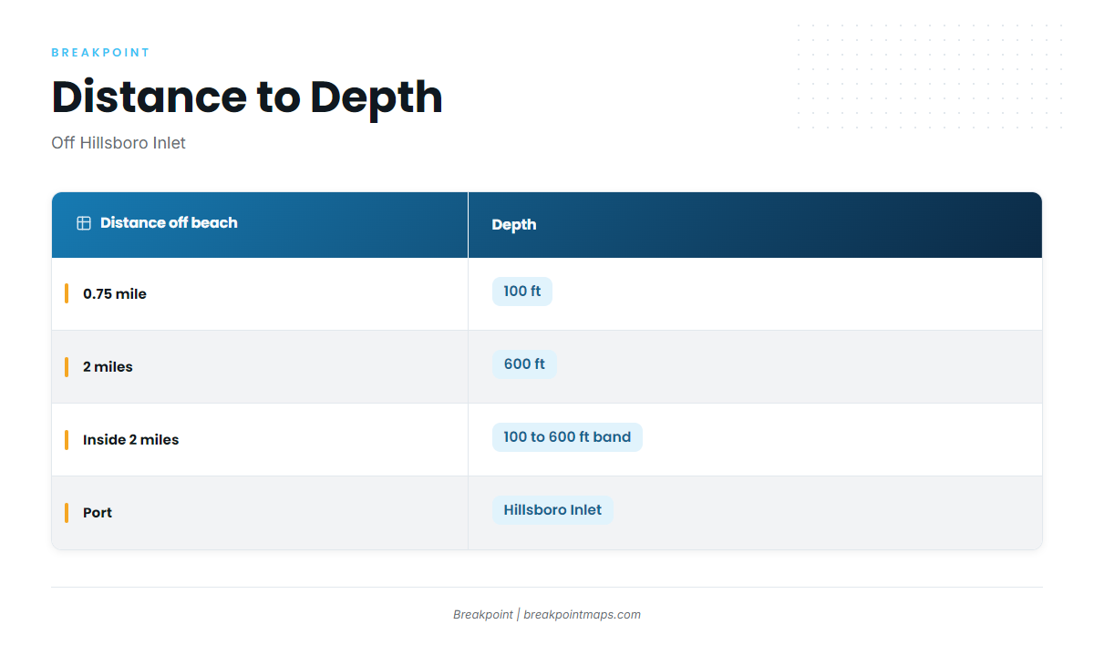
Bottom fishing out of Hillsboro Inlet reaches deep water in a short run. The 100 to 600 ft band is a matter of miles, not tens of miles, and sits entirely inside 2 miles of the beach.
Distance to depth
| Distance off the beach | Depth |
|---|---|
| 0.75 mile | 100 ft |
| 2 miles | 600 ft |
Grounds and structure near Pompano Beach
The shelf comes first, followed by the named sites. Grid references come from the Pompano Beach visitor dive map.
Sailfish Alley and the Edge
Sailfish Alley, also called the Edge, is the shelf drop-off. It sits inside the 100 to 600 ft gradient described above.
Shipwreck Park: Lady Luck and Okinawa
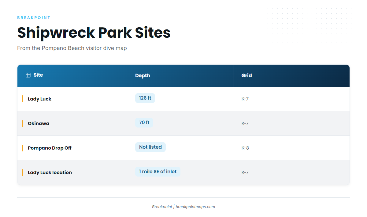
Both wrecks sit in Shipwreck Park, grid K-7 on the Pompano Beach visitor dive map.
| Site | Depth | Location | Grid |
|---|---|---|---|
| Lady Luck | 126 ft | About 1 mile SE of Hillsboro Inlet | K-7 |
| Okinawa | 70 ft | Shipwreck Park | K-7 |
Pompano Drop Off
Pompano Drop Off sits in grid K-8 on the Pompano Beach visitor dive map.
Named ledges and reefs
- Pompano Trench
- Lost Ledge
- Suzzane’s Ledge
- Pompano 3rd Reef Ridge
- Steve’s Twin Ledges
- Shark Reef
- Touchdown Reef
- Grouper Bend
- Nursery
Named wrecks
Named wrecks near the port include Sucre, Miller Lite, Mariner II Tug, Union Express, Mary St. Philip, Rodeo 25, Quallman Tugs, RSB-1, RBJ, Chris Corey, Renegade, Lowrance, Captain Dan, Guy Harvey, SS Copenhagen and Caicos Express.
Listed dive sites
Hillsboro Ledge, Lighthouse Ledge and Horseshoe Reef are listed as Pompano Beach dive sites. Treat them as landmarks on the map.
You can save these names and grid references as waypoints in Breakpoint and turn on Chart Contours to see the 100 to 600 ft band. Chart layers are not for navigation.
How it is fished here
The local approach is bottom fishing out of Hillsboro Inlet in the 100 to 600 ft band, over the wrecks and ledges listed above.
Bottom fishing the deep water
Technique is covered in our reef fish guides.
Who fishes for them
Killin’ Time Charter out of Pompano lists vermilion snapper and runs the 53′ Hatteras ‘Killin Time’.
FAQ
How far from Hillsboro Inlet is deep water?
100 ft sits 0.75 mile off the beach and 600 ft sits 2 miles out.
What depth is Lady Luck?
126 ft, about 1 mile SE of Hillsboro Inlet, in grid K-7.
Where is Shipwreck Park?
Shipwreck Park holds Lady Luck and Okinawa, both in grid K-7 on the Pompano Beach visitor dive map.
When are vermilion snapper reported here?
Killin’ Time Charter’s September fishing report page mentions vermilion snapper.
Is there a charter that targets vermilion snapper fishing out of Pompano Beach?
Killin’ Time Charter lists the species and runs a 53′ Hatteras.