




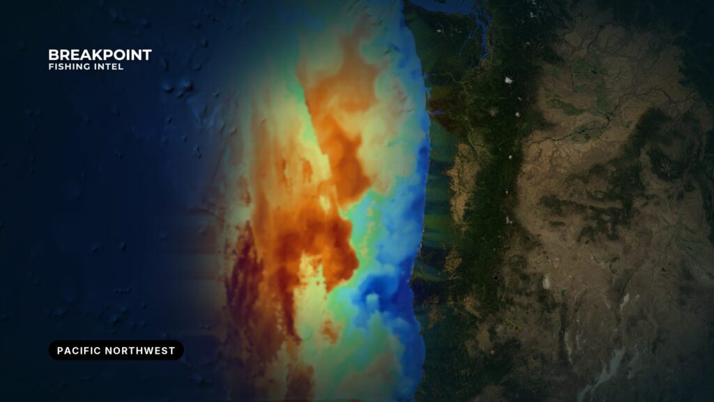
This guide covers the ocean coast of Washington, Oregon and northern California as one system, from Cape Flattery to the Noyo River. WDFW, ODFW and CDFW each set their own seasons, limits and closures. Use it as a planning map: how the coast works port by port, what drives the fish, what gates each trip and which port opens to which water.
What Defines the Fishery
The fishery runs on a chain of cause and effect. Wind drives upwelling, upwelling decides where fish hold, the bar decides whether you get to them, and the rules decide what you can keep. Every port entry below depends on that chain, whether you fish Washington or Oregon coast waters.
Upwelling
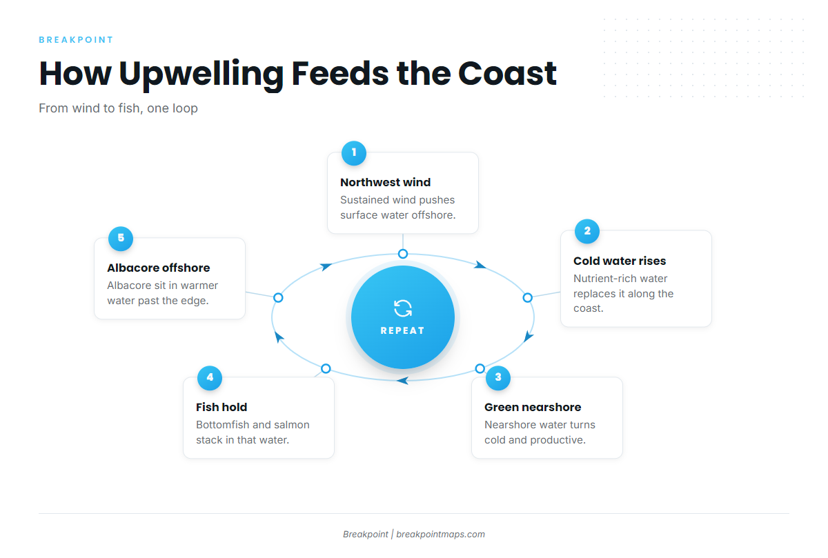
Sustained northwest wind pushes surface water offshore. Cold, nutrient-rich water rises along the coast to replace it, turning nearshore water cold and green.
Bottomfish and salmon hold in that cold, productive water. Albacore sit in the warmer water beyond the upwelled edge, which is why albacore tuna fishing in the Pacific Northwest follows warm breaks offshore.
The wind record supports this. Near Crescent City, northwest through north winds are most common in summer, reinforced by the sea breeze, and winds of 20 to 30 knots occur 10 to 20 percent of the time.
The OBS SST layer shows temperature breaks, and the Chlorophyll layer shows upwelled green water. Reading both before you leave the dock helps you decide where to run. They won’t promise fish, but they narrow the search.
Both layers have limits. Cloud can block a satellite SST pass, and the Coast Pilot notes frequent advection fog off Crescent City from July through September, which overlaps albacore months. When a pass is blank, the layer does not fill in a guess.
The Bars
Nearly every trip on this coast is gated by a bar or harbor entrance and the tide. The named crossings are the Grays Harbor Bar, the Columbia River Bar, the Umpqua River Bar and the Humboldt Bay bar.
Peak ebb combined with swell is the condition to watch. Outgoing current runs against incoming swell, which steepens and shortens the waves on the bar. Experienced boaters at Grays Harbor plan around the bar and avoid crossing during peak outgoing tides.
Humboldt Bay shows how this plays out in numbers. According to NOAA U.S. Coast Pilot 7, the bar is often passable late in the flood and impassable about 2 hours later, once the ebb has set in. Current between the jetties averages about 2 knots with a maximum near 4 knots, and storm velocities can reach 5.5 knots. The Coast Guard warning sign at Station Humboldt Bay flashes yellow when seas exceed 6 feet.
The Humboldt bar shifts and shoals, especially in winter, and the entrance ranges may not mark the deepest channel. Federal project depth is 48 feet over the bar, with regular maintenance dredging.
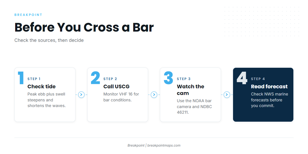
Bar conditions are available from these sources:
- Grays Harbor: The Coast Guard on VHF 16, the NOAA bar camera and NDBC Station 46211, all collected on the Grays Harbor bar conditions page.
- Umpqua River: The bar report readerboard near the Coast Guard station.
- Humboldt Bay and Crescent City: NWS Eureka marine forecasts and the Coast Guard.
A forecast is only a forecast, so check the bar cam and the Coast Guard before you commit.
Chart Contours shows bottom structure, which helps with planning where to fish once you are outside. Chart layers are not for navigation.
How Seasons Are Set
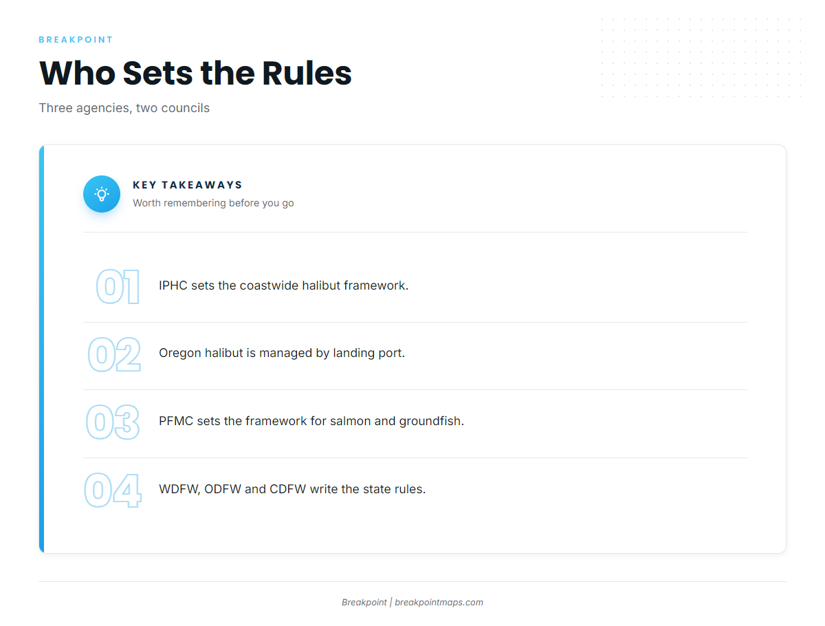
Three bodies set the frame, and the state agencies write the details inside it:
- Halibut: The IPHC sets the coastwide framework, and state rules apply inside it. Oregon manages sport halibut by port of landing. Because the quota is tracked by subarea, halibut may be landed only into ports within areas open to retention, regardless of where they were caught. The Central Oregon Coast subarea runs from Cape Falcon to Humbug Mt. and has a nearshore season inside the 40-fathom line and an all-depth season.
- Salmon: The PFMC sets the framework for chinook and coho, and dates move through that process.
- Groundfish: The PFMC sets the framework for rockfish and lingcod, and the states apply it.
The agencies set the openers, and they change with quota.
The Species
Rockfish, lingcod and dungeness crab are the backbone of winter and spring fishing at the Oregon ports. Halibut and chinook come in spring and summer, and coho in summer and autumn. Albacore are offshore in summer and autumn. Flatfish such as sanddabs and petrale sole show up at Newport, and at Eureka, California halibut, sharks and bat rays appear in season.
Shore anglers work nearshore species such as surfperch and greenling. The Westport Jetty at Westport Light State Park and the Umpqua Jetty are the named shore options.
The Coast by Port
Ports run north to south. Each entry covers the water, the entrance, where to read conditions, species by season and the ramp or marina.
Washington
- Neah Bay: Washington coast port north of Westport. See lingcod fishing off Neah Bay.
- La Push: Washington coast port north of Westport.
- Westport: Westport Marina sits at the mouth of Grays Harbor and is described as Washington’s largest fish landing port. WDFW says Marine Area 2 is accessed primarily from the Port of Westport. Charter runs go 5 to 20 miles offshore for salmon and bottomfish, 25 to 50 miles for halibut and 40 to 100 miles for albacore. The crossing is the Grays Harbor Bar, read on VHF 16, the NOAA bar camera and NDBC 46211. Spring brings chinook, lingcod and rockfish. Summer adds coho and halibut, and autumn carries chinook. Ramps and marinas: the 28th Street Ramp, and Westport Marina with fuel listed. Launch lines can run long on weekend mornings, and WDFW recommends a local experienced guide for first trips. Read more in Pacific halibut fishing off Westport.
- Ilwaco: Washington coast port south of Westport, at the Columbia River Bar.
Check WDFW before fishing: WDFW Marine Area 2 rules.
Oregon
- Astoria: Oregon’s northernmost coast port.
- Garibaldi: Just below Cape Falcon, in the Central Oregon Coast halibut subarea.
- Pacific City: In the same Central Oregon Coast halibut subarea.
- Depoe Bay: Next port north of Newport, and it appears on the ODFW Newport halibut grounds map.
- Newport: Yaquina Bay, with a jettied entrance. The recreational marina and ramp are at South Beach, with fuel listed. The marina monitors VHF 12 and requires pre-registration. The Bayfront commercial marina is for commercial vessels only, and transient vessels check in at the port administration building first. Named grounds are Banana Bank, North Rock Pile and Chicken Ranch. Stonewall Bank Yelloweye Rockfish Conservation Area lies about 15 miles west. It is closed to halibut and marked closed for bottomfish on the ODFW Newport halibut map. A vessel carrying halibut is barred from fishing there even when targeting other species, and salmon fishing there is limited to trolling on open all-depth halibut days. Winter brings rockfish, lingcod and crab. Summer adds halibut, chinook, coho, albacore and flatfish. Conditions and notices are in the ODFW Marine Zone report. For the offshore run, see albacore tuna fishing off Newport.
- Winchester Bay: At the Umpqua River mouth, with north, south and training jetties shaping the entrance. Salmon Harbor has East and West Launches, plus the Rainbow Plaza ramp in Reedsport. Charters fish the river or the ocean for salmon depending on where the fish are, and run offshore for bottomfish, halibut and tuna. Winter brings rockfish, lingcod and crab. Summer adds chinook, halibut and albacore, and autumn brings coho. Shore option: the Umpqua Jetty.
- Charleston: Next port south. Some Winchester Bay operators run from it.
- Bandon and Brookings: Oregon ports farther south along the coast.
Check ODFW before fishing: ODFW Marine Zone regulations.
Northern California
- Crescent City: A breakwater harbor on the open Pacific, with Citizens Dock and the boat basin, both with fuel listed, plus a harbor ramp. Lighted buoys and a range mark the entrance. The harbor is open to the south, and the "kick back" southeast wind follows strong northwest wind outside. It usually starts in the early afternoon and ends about midnight. In the approaches, Chase Ledge is covered 21 feet and lies 0.9 mile south of Round Rock, and foul ground runs northwest for 3.5 miles to Point St. George. Read conditions on the NWS Eureka marine forecasts. Rockfish, lingcod and halibut start in spring, with chinook and albacore in summer.
- Trinidad: Trinidad Head lies 17.5 miles north of the Humboldt entrance. Fishing boats use the harbor in summer.
- Eureka: Humboldt Bay is a deep-draft harbor reached through the jettied bar described above. Ramps and marina: Woodley Island Marina, Eureka Public Marina ramp, Fields Landing and the Samoa Peninsula ramp. Halibut grounds run from the 48-line to the 53-line. For Cape Mendocino rockfish trips, Blunts Reef lies 2.6 miles west of the cape, and the Coast Pilot advises against the passage between Buoy 40 and the cape under any circumstances.
- Shelter Cove: An open-ocean launch past Cape Mendocino, maintained by the Humboldt Bay Harbor District, less than two hours south of Humboldt Bay.
- Fort Bragg: Next major fishing center to the south, at the Noyo River.
Check CDFW before fishing: CDFW Pacific halibut page.
Season Overview
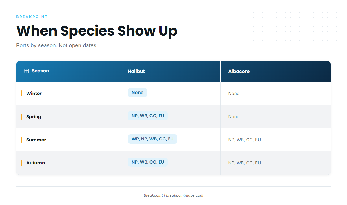
Each cell lists the ports where the species appears. WP = Westport, NP = Newport, WB = Winchester Bay, CC = Crescent City, EU = Eureka.
| Season | halibut | lingcod | rockfish | chinook | coho | albacore | dungeness crab |
|---|---|---|---|---|---|---|---|
| Winter | none | NP, WB | NP, WB | none | none | none | NP, WB |
| Spring | NP, WB, CC, EU | WP, NP, WB, CC, EU | WP, NP, WB, CC, EU | WP, NP | none | none | NP, WB, EU |
| Summer | WP, NP, WB, CC, EU | NP, WB, CC, EU | NP, WB, CC, EU | WP, NP, WB, CC, EU | WP, NP | NP, WB, CC, EU | NP, WB |
| Autumn | NP, WB, CC, EU | NP, CC, EU | NP, CC, EU | WP, NP | NP, WB | NP, WB, CC, EU | NP, WB, EU |
Swipe the table sideways to see every column.
Openers, quotas and closures are set by the agencies and change with quota. The table shows when species appear, not when they are open.
If your dates are fixed, find your month in the table first, then check the agency for openers.
Rules and Conditions
Rules and conditions come from these sources:
- WDFW: Marine Area 2 rules and access for Westport.
- ODFW Marine Zone: In-season changes for ocean salmon, halibut and bottomfish.
- CDFW: Pacific halibut closure notices and in-season tracking.
- IPHC and PFMC: The halibut, salmon and groundfish frameworks behind the state rules.
- NWS Eureka: Marine forecasts for the Northern California coast.
- NDBC Station 46211 and the Grays Harbor bar camera: Washington bar and offshore conditions.
- USCG on VHF 16: Bar conditions.
- Umpqua bar readerboard: The current Umpqua River bar report.
- NOAA Coast Pilot 7: Entrance, current and hazard notes from San Francisco Bay to Point St. George.
Yelloweye Rockfish Conservation Areas define where you can legally fish, so use the agency maps for boundaries.
Chart layers are not for navigation. This guide gives the numbers and points to the official forecast. Check the agency before fishing.
Species and Local Guides
The guides below are grouped by species and region.
Offshore tuna
- Albacore tuna fishing in the Pacific Northwestreading warm breaks and SST for albacore along the whole coast.
- Albacore tuna fishing off Newport, Oregonthe offshore run out of Yaquina Bay.
- Pacific bluefin tuna fishing in the Pacific Northwestthe warm-water offshore extension beyond albacore.
Halibut and bottomfish
- Pacific halibut fishing off Westporthalibut grounds out of Grays Harbor and Marine Area 2.
- Lingcod fishing off Neah Baylingcod at Washington’s northwest corner.