Where Mayport wahoo boats run
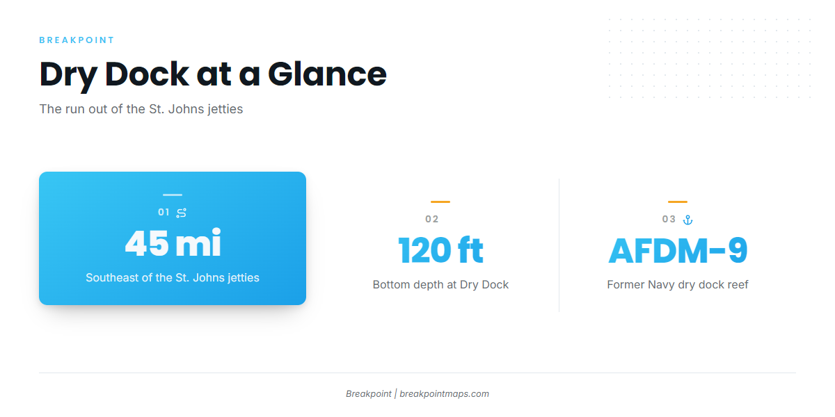
Wahoo fishing out of Mayport centers on Dry Dock (AFDM-9), an artificial reef about 45 miles southeast of the St. Johns jetties. The reef is a former Navy dry dock sitting in about 120 ft of water.
Plan fuel from your own boat’s burn rate at cruise: 45 miles out, 45 miles back, plus whatever running you do on the grounds. The Mayport port page covers getting out through the jetties and where to read conditions. The shallower reefs and FWC-listed sites are laid out with depths and coordinates in the grounds section below.
| Item | Figure |
|---|---|
| Destination | Dry Dock (AFDM-9) |
| Distance | About 45 miles southeast of the St. Johns jetties |
| Depth | About 120 ft |
When wahoo show up at Dry Dock
Dry Dock reports describe wahoo there in the past several years. That is the local record for this ground.
For general timing and biology, see the wahoo species guide. For the regional picture, read the Atlantic Southeast wahoo guide (see also the Atlantic Southeast fishing guide).
Grounds and structure off Mayport
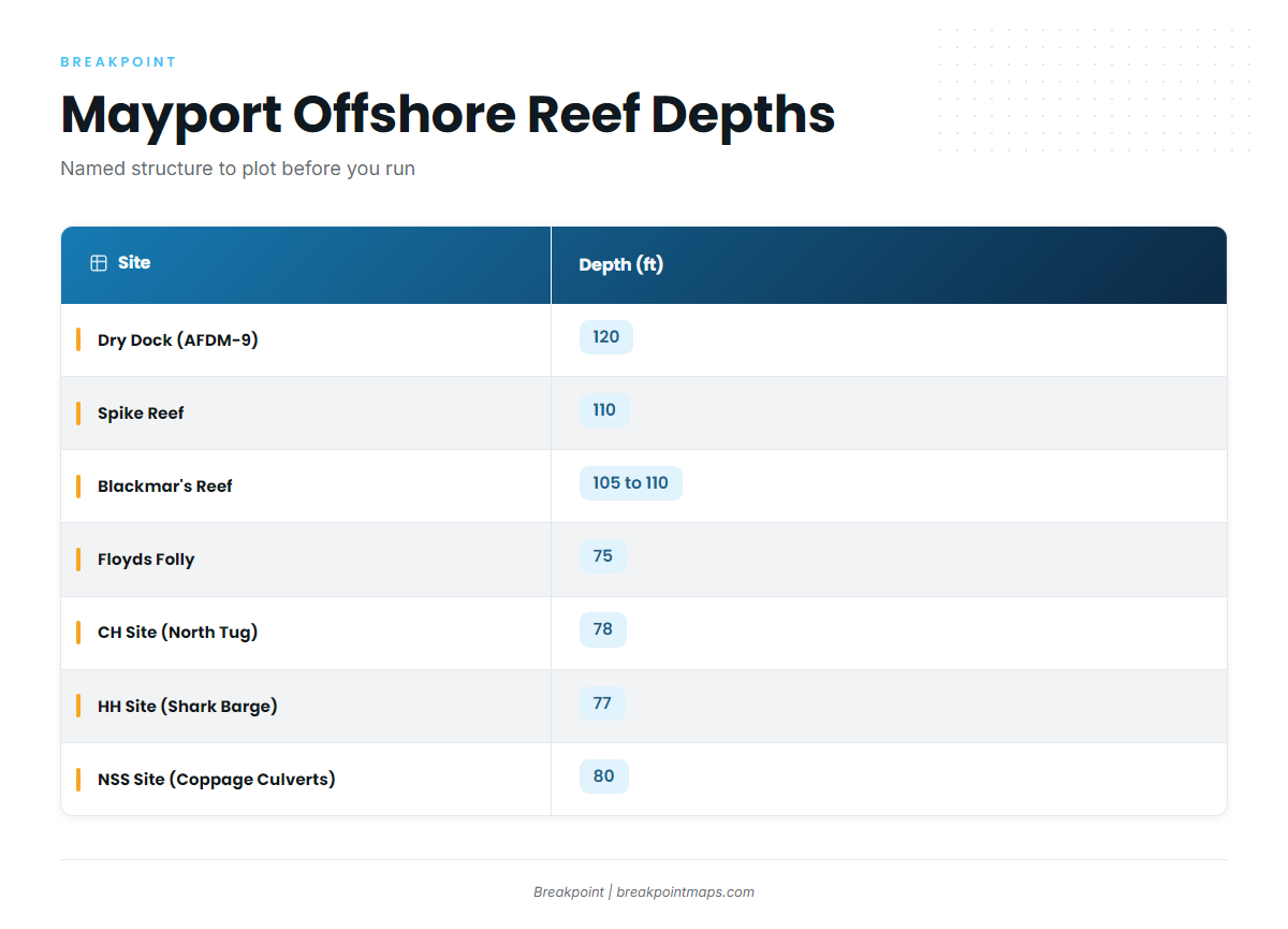
These are the named Jacksonville offshore artificial reefs and structure off Mayport that anglers plot for the run.
Deep artificial reefs: Dry Dock, Spike Reef, Blackmar’s Reef
Dry Dock (AFDM-9) is the deepest of the named reefs at about 120 ft.
Spike Reef has a bottom of about 110 ft and a wreck top of about 75 ft. That leaves about 35 ft of relief, so on the sounder the wreck shows as a tall mark rising from 110 ft to about 75 ft.
Blackmar’s Reef sits in 105 to 110 ft of water.
The 75 to 80 ft FWC sites: Floyds Folly, NSS, HH, CH
Four sites carry coordinates from the FWC table: Floyds Folly, NSS Site (Coppage Culverts), HH Site (Shark Barge) and CH Site (North Tug). Depths run 75 to 80 ft.
Coppage Culverts at the NSS Site, about 80 ft, is a different listing from Coppedge Tug, which Visit Jacksonville lists separately as a shallow-water site. Keep the two waypoints separate.
Nine Mile Reef
Nine Mile Reef is a named reef near Mayport.
| Site | Depth (ft) | Latitude | Longitude | Notes |
|---|---|---|---|---|
| Dry Dock (AFDM-9) | 120 | Former Navy dry dock, about 45 miles southeast of the St. Johns jetties | ||
| Spike Reef | 110 | Wreck top about 75 ft | ||
| Blackmar’s Reef | 105 to 110 | |||
| Floyds Folly | 75 | 30 10.034 N | 81 09.322 W | FWC table |
| NSS Site (Coppage Culverts) | 80 | 30 17.296 N | 80 57.598 W | FWC table. Not Coppedge Tug |
| HH Site (Shark Barge) | 77 | 30 00.950 N | 81 04.718 W | FWC table |
| CH Site (North Tug) | 78 | 30 18.560 N | 81 04.150 W | FWC table |
| Nine Mile Reef |
Swipe the table sideways to see every column.
Chart layers are not for navigation. Plot the coordinates and check them against Chart Contours before you run.
How wahoo are fished here
The local depths shape the approach. Dry Dock at 120 ft, Spike Reef at a 110 ft bottom with a 75 ft top, and Blackmar’s at 105 to 110 ft give you named, plottable structure in 105 to 120 ft.
Work the structure you can mark on the sounder. Spike Reef is a useful reference: a 75 ft top over a 110 ft bottom shows up on the sounder before you reach it. In practice, that means picking a named ground, plotting it, and reading the bottom on arrival.
- Dry Dock: about 120 ft
- Spike Reef: 110 ft bottom, wreck top about 75 ft
- Blackmar’s Reef: 105 to 110 ft
Who fishes for wahoo out of Mayport
Two local charters list wahoo. Either is worth contacting to learn the grounds before you run your own boat, and both also work other offshore gamefish.
- Strate Fishing Charters: Capt. Matt Strate
- Always Hookin Fishing Charters: Capt. Big Greg, Captain Gregory and 1st Mate Jadyn
FAQ: wahoo fishing out of Mayport
How far is Dry Dock from Mayport?
About 45 miles southeast of the St. Johns jetties. The reef is Dry Dock (AFDM-9).
How deep is Dry Dock?
About 120 ft. It is a former Navy dry dock artificial reef.
When are wahoo at Dry Dock?
Dry Dock reports describe wahoo there in the past several years.
What is the depth at Spike Reef?
Bottom about 110 ft, wreck top about 75 ft.
Which Mayport charters list wahoo?
Strate Fishing Charters (Capt. Matt Strate) and Always Hookin Fishing Charters (Capt. Big Greg, Captain Gregory and 1st Mate Jadyn).