Gray triggerfish fishing out of St. Marys, Georgia, is bottom fishing, and the grounds run from the St. Marys jetties at the inlet out to the Ledge on the continental shelf. Inlet and launch details are in our St. Marys port guide. What follows covers run distances, depths and the one published coordinate, ordered from the inlet outward. The wider picture is in the gray triggerfish fishing in the Atlantic Southeast and the Atlantic Southeast region guide.
How far boats run from St. Marys
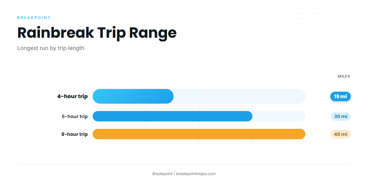
Rainbreak’s 6-hour and 8-hour trips run up to 30 and 40 miles, and its 12-hour trips go to the Ledge. The jetties and the FA fish haven sit at the inlet, Reef KBY is 8 nautical miles east of Cumberland Island, and the Ledge lies beyond the 8-hour range.
| Trip length | Run |
|---|---|
| 6 hours | Up to 30 miles |
| 8 hours | Up to 40 miles |
| 12 hours | The Ledge |
Grounds and structure off St. Marys
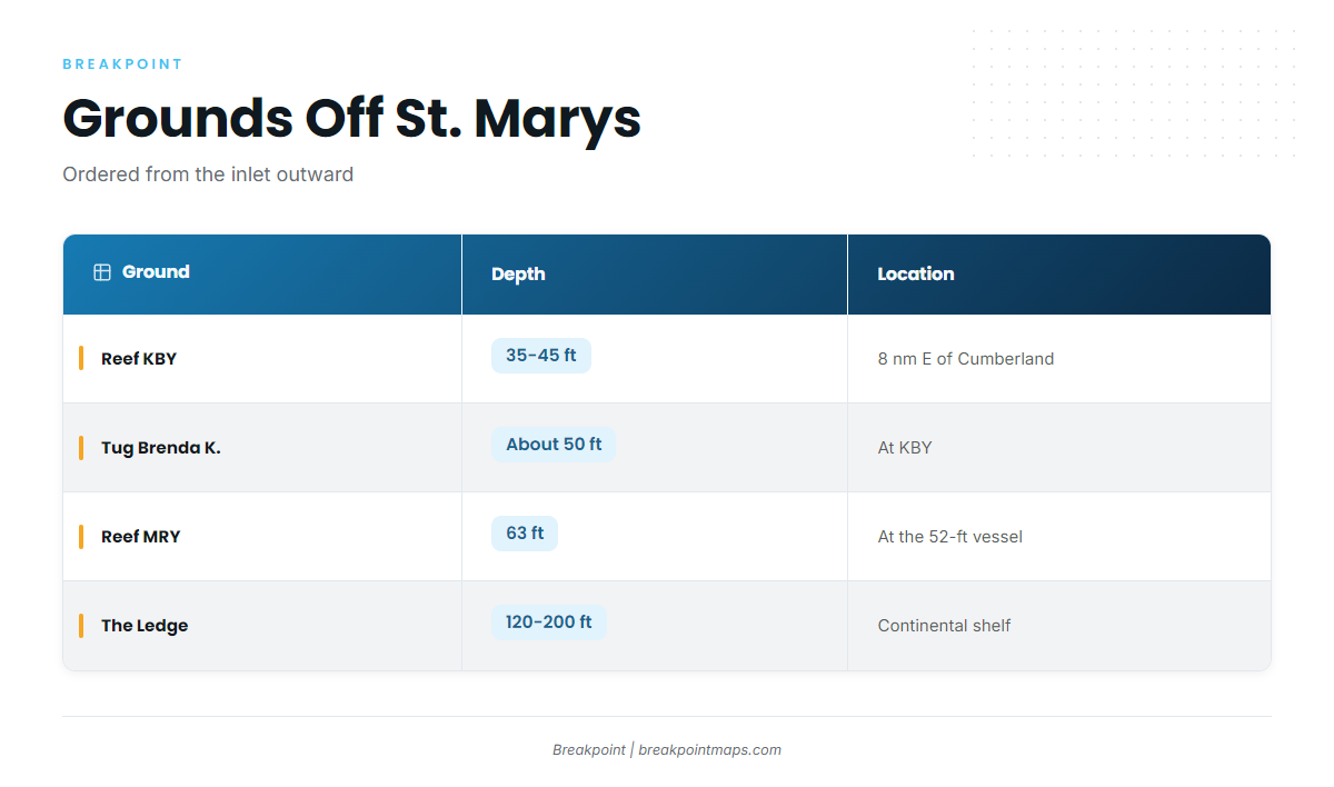
The near grounds mix Georgia DNR artificial reefs and inlet structure. For regional context on reef species, see our reef fish guides.
| Ground | Depth | Location |
|---|---|---|
| St. Marys jetties (north and south) | At St. Marys Inlet | |
| FA fish haven | Florida side of the inlet | |
| Reef KBY | 35-45 ft | 8 nautical miles east of Cumberland Island |
| Tug Brenda K. | about 50 ft | At KBY, 30.805283, -81.27555 |
| Reef MRY (Metalmorphosis) | 63 ft at the vessel | |
| The Ledge / Big Ledge | 120 to 200 ft | Continental shelf |
St. Marys jetties
The north and south jetties flank St. Marys Inlet and are the closest structure to port.
FA fish haven
The FA fish haven is live bottom with a tug and a barge, on the Florida side of the inlet.
St. Marys Sea Buoy
The St. Marys Sea Buoy is a named reference point off the inlet. Use it to orient your run, not as a place to fish.
Reef KBY
Reef KBY is a Georgia DNR reef in 35-45 ft, 8 nautical miles east of Cumberland Island. It is the nearest of the named reefs to the inlet.
Tug Brenda K.
The tug sits at KBY in about 50 ft. Its coordinate is:
30.805283, -81.27555
Plot it against the Chart Contours layer. Chart layers are not for navigation. The Brenda K. is the only structure covered here with a published coordinate.
Reefs A and CDH
Reefs A and CDH are listed as nearby reefs on the KBY page.
Reef MRY (Metalmorphosis)
Reef MRY is a 52-ft steel vessel with 63 ft of water at the vessel. DNR describes MRY as deeper, with clearer water than KBY.
The Ledge
The Ledge, also called the Big Ledge, sits at the continental shelf. Trolling starts at 120 ft and runs to 200 ft, and Rainbreak runs 12-hour trips there. Depths step down in order: KBY at 35-45 ft, MRY at 63 ft, and the Ledge at 120 to 200 ft.
How triggerfish are fished here
The local method is bottom fishing, on the reefs and structure above. For rigs, bait and the species’ seasonal picture, see our gray triggerfish guide.
Who fishes for them out of St. Marys
Rainbreak Charters out of St. Marys lists gray triggerfish, with Captain James (Michael) Walker. Its 6-hour, 8-hour and 12-hour trips cover the range from the near reefs to the Ledge.
FAQ about gray triggerfish fishing out of St. Marys
How far is Reef KBY from St. Marys?
Reef KBY sits 8 nautical miles east of Cumberland Island, in 35-45 ft.
What is the Brenda K. coordinate?
The tug Brenda K. is at 30.805283, -81.27555, in about 50 ft at KBY. Chart layers are not for navigation.
How deep is Reef MRY?
Reef MRY has 63 ft at the 52-ft steel vessel. DNR describes it as deeper, with clearer water than KBY.
How far do charter trips run from St. Marys?
Rainbreak’s 6-hour and 8-hour trips run up to 30 and 40 miles. Its 12-hour trips go to the Ledge.
How deep is the Ledge off St. Marys?
Trolling at the Ledge starts at 120 ft and runs to 200 ft, at the continental shelf.