




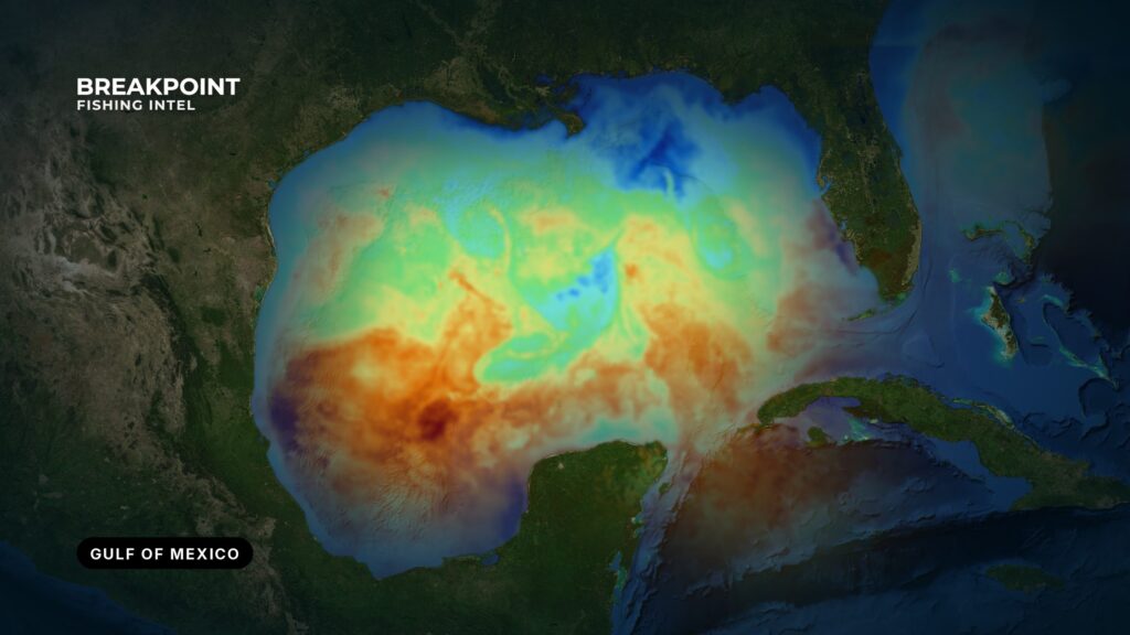
The Gulf of Mexico fishes by structure and water: platforms, banks, reefs and wrecks on the bottom, and the Loop Current and river plumes on top. Both change from Texas to the Florida west coast, so the shelf you launch onto decides how far you run and what you fish. This Gulf of Mexico fishing guide covers the species, structure and seasons area by area. Start with the water and the bottom here, then move to the species or local guide that fits your trip.
Federal agencies use the name Gulf of America, so you will see it on NOAA regulation pages and some charts. It is the same water.
How the Gulf of Mexico fishes by area
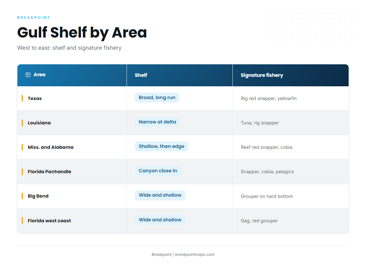
The Gulf changes character from west to east. Shelf width sets the run, structure sets the fish, and river water sets the clarity. Inshore, redfish, speckled trout, snook and tarpon fish the bays, passes and flats from Texas to Florida. The sections below cover the offshore picture.
Texas
The shelf is broad, with a long run to deep water off the middle and lower coast. Most of what you fish is built rather than natural.
- Shelf: wide and gradual, with deep water a long way out.
- Structure: nearshore and offshore oil and gas platforms, plus reefs from Texas Parks and Wildlife’s artificial reef program. The Flower Garden Banks sit far offshore of the upper coast.
- Fisheries: rig fishing for red snapper, bluewater yellowfin tuna on deepwater platforms, and redfish and speckled trout in the bays and along the jetties.
The run to deepwater platforms defines a Texas offshore day, and the yellowfin tuna off Port Aransas guide covers it.
Louisiana
The shelf narrows off the Mississippi delta, so bluewater sits close to Venice, which shapes everything about fishing there.
- Shelf: the narrowest in the Gulf, which puts deep water near the delta.
- Structure: the densest platform field in the Gulf, plus river plume edges that move with flow and wind.
- Fisheries: yellowfin and blackfin tuna, rig snapper and amberjack offshore, and redfish and speckled trout in the marsh.
For the run out of the delta, see yellowfin tuna off Venice, Louisiana.
Mississippi and Alabama
Inshore bottom is shallow and soft. Offshore, the shelf edge and De Soto Canyon lie to the southeast.
- Shelf: shallow, soft bottom close in, then a step to the edge.
- Structure: large permitted artificial reef zones off Alabama, and platforms to the west.
- Fisheries: red snapper on artificial reefs, king mackerel and cobia, and speckled trout and redfish around Mississippi Sound and Mobile Bay.
Alabama’s reef zones are the center of the snapper fishery. See red snapper off Orange Beach.
Florida Panhandle
The shelf edge and De Soto Canyon put deep water within reach of Destin and Pensacola, much closer than on the Big Bend.
- Shelf: narrow compared with the Big Bend, with a steep break close to shore.
- Structure: artificial reefs, wrecks and the Oriskany off Pensacola.
- Fisheries: red snapper, cobia on their spring run along the beaches, king mackerel, and pelagics at the canyon.
The red snapper off Destin guide covers reef and ledge fishing from that port.
Big Bend
The shelf is very wide and shallow, with limestone hard bottom and ledges. It is a long run to depth, and the water stays shallow far from shore.
- Shelf: wide and shallow, the longest run to depth in the northern Gulf.
- Structure: limestone hard bottom and ledges.
- Fisheries: grouper on hard bottom, and redfish, speckled trout and tarpon on the flats.
Florida west coast
The wide, shallow shelf continues, so it takes a long run to reach depth off Tampa Bay and Sarasota.
- Shelf: wide and shallow, with depth well offshore.
- Structure: ledges, hard bottom and artificial reefs.
- Fisheries: gag and red grouper on hard bottom, blackfin tuna when bait and blue water push in, and snook and tarpon inshore.
For hard-bottom grouper, see gag grouper off Tampa Bay.
What makes the Gulf of Mexico fish
Fish hold where structure or an edge concentrates bait. In the Gulf that means fixed structure on the bottom and moving water above it. Once you know both, the map starts to make sense.
Oil and gas platforms and Rigs to Reefs
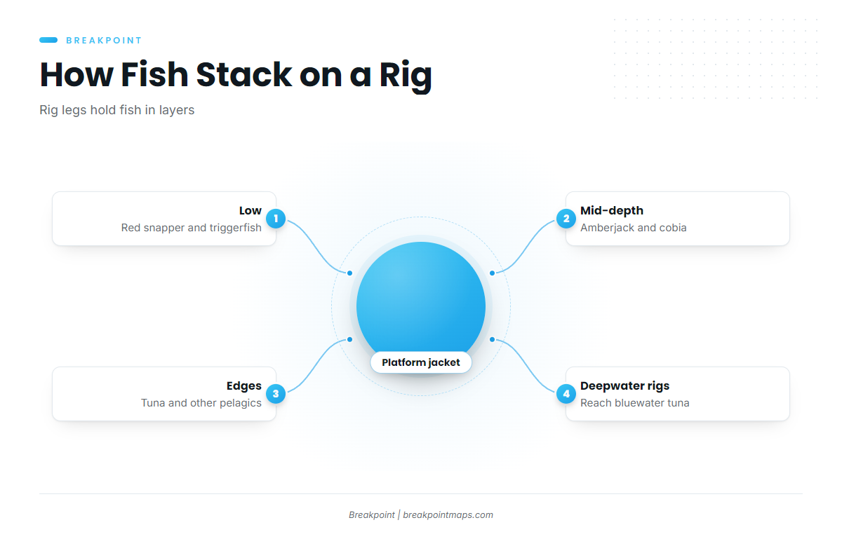
A platform acts as an artificial reef. The jacket, the steel frame that holds a fixed platform’s deck, grows food, creates shelter and concentrates bait, so predators show up. BSEE on Gulf platform fishing covers why these structures draw offshore anglers. BSEE also runs the Rigs to Reefs program, which turns decommissioned platforms into permanent reefs.
Fish stack in layers on the legs:
- Low on the structure: red snapper and triggerfish.
- Mid-depth: amberjack and cobia.
- Around the edges: tuna and other pelagics cruising the perimeter.
- Deepwater production platforms: these reach bluewater tuna.
Rigs to Reefs sometimes leaves a platform partially removed, or toppled in place, which keeps structure on the bottom. Platforms do come out, though. A rig that held snapper last year may be gone, so treat an old waypoint as a lead and confirm it on the sounder.
Natural banks and the Flower Garden Banks
Hard-bottom banks and salt-dome reefs rise off the Texas and Louisiana shelf. Flower Garden Banks National Marine Sanctuary protects the best known of them. Relief on a bank interrupts current, lifts nutrients and holds reef fish and passing pelagics. Sanctuary rules apply on and around the banks, so check with the sanctuary before you fish.
Artificial reefs
State and county reef programs off Texas, Alabama and Florida put purpose-built structure on the shelf, and Mississippi and Louisiana run programs of their own.
- Low relief: holds snapper and triggerfish.
- High relief: holds amberjack.
- Rules: some reef zones carry their own gear rules, so check the state agency.
Wrecks
Wrecks hold reef fish and amberjack, with pelagics working overhead. The Oriskany off Pensacola is the best known wreck reef in the northern Gulf. Marine life takes hold within weeks of a sinking, with baitfish first and predators close behind.
Shelf edge and contour lines
Any abrupt depth change that interrupts horizontal current generates some vertical lift. That includes the shelf edge and the 20-fathom (120-foot) and 30-fathom (180-foot) lines. The lift concentrates bait, and predators follow. De Soto Canyon is a steep break close to the Panhandle and Alabama.
The Loop Current and its eddies
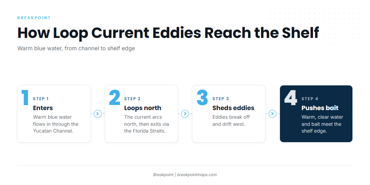
Warm, blue water enters the Gulf through the Yucatan Channel, loops north and exits through the Florida Straits. Eddies periodically shed from the loop and drift west. When an eddy or the loop itself pushes toward the shelf edge, it carries warm, clear water and bait with it, which brings tuna, billfish and mahi within reach. Bait stacks where warm water meets cooler water, so the edge matters more than the middle of either side. Sargassum weedlines along those edges hold mahi and tripletail.
The Mississippi and Atchafalaya plumes
A color line is the visible edge where green or brown river water meets blue Gulf water. River water carries nutrients, nutrients feed chlorophyll, and chlorophyll feeds bait. Predators work the clean side of the edge.
You can read the edge three ways: temperature, color and chlorophyll. Plumes shift with river flow and wind, so an edge can move between one day and the next. The Loop Current edge shows on the OBS SST layer and plume color lines show on Chlorophyll, though cloud blocks some satellite passes.
Gulf of Mexico season overview
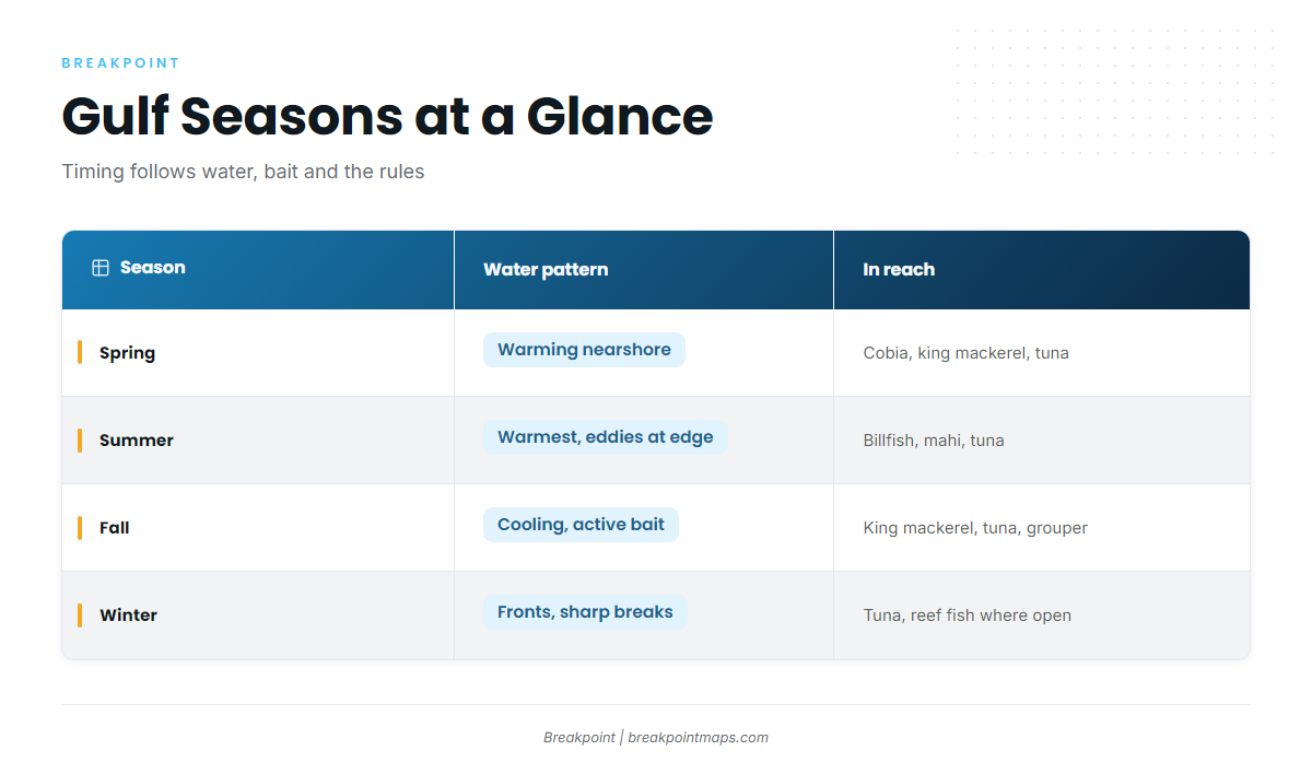
Timing follows water temperature, bait and the rules. Read the table as a general pattern rather than a calendar.
| Season | Water pattern | What’s in reach | Notes |
|---|---|---|---|
| Spring | Warming nearshore water | Cobia and king mackerel moving along the coast, tuna on deepwater rigs | Red snapper season set by NOAA or the state, check before fishing |
| Summer | Warmest water, with Loop Current eddies near the shelf edge | Billfish, mahi on weedlines, tuna | Hurricane season shapes planning, so watch the NWS marine forecast |
| Fall | Cooling water and active bait | King mackerel, tuna, grouper on hard bottom | Gag and amberjack seasons set by NOAA or the state, check before fishing. Hurricane season continues |
| Winter | Cold fronts and stronger temperature breaks | Tuna on deepwater rigs, reef fish where open | Plume edges are often sharp after high river flow |
Hurricane season shapes summer and fall planning, so check the National Weather Service marine forecast before every run.
Gulf of Mexico species guides
Rigs and banks hold tuna and cobia, and edges and weedlines hold mahi, wahoo and billfish. Pick the species, then read its guide.
Tunas
- Blackfin tuna in the Gulf of Mexicoblackfin tuna on rigs, shelf-edge bait and Loop Current water across the Gulf.
- Yellowfin tuna in the Gulf of Mexicoyellowfin tuna on deepwater platforms, plume edges and eddies.
Billfish and swordfish
- Blue marlin in the Gulf of Mexicoblue marlin on Loop Current eddies and deepwater structure.
- White marlin in the Gulf of Mexicowhite marlin on temperature edges and canyon water.
- Sailfish in the Gulf of Mexicosailfish on color lines and bait near the shelf edge.
- Swordfish in the Gulf of Mexicoswordfish in deep water off the shelf, by day and by night.
Bluewater pelagics
- Mahi-mahi in the Gulf of Mexicomahi on sargassum weedlines, color lines and floating debris.
- Wahoo in the Gulf of Mexicowahoo on deepwater rigs, ledges and blue-water edges.
Coastal pelagics
- Cobia in the Gulf of Mexicocobia on the spring coastal run, buoys, rigs and reefs.
- King mackerel in the Gulf of Mexicoking mackerel on nearshore reefs, rigs and bait schools.
- Spanish mackerel in the Gulf of MexicoSpanish mackerel on beaches, passes and nearshore bait.
All species
- Saltwater fish species guides – every species guide, from reef fish to bluewater.
Gulf of Mexico local guides
The guides run west to east. Each one covers a single port and the structure within its reach.
Texas
- Yellowfin tuna off Port Aransas – Port Aransas: the long run across a broad shelf to deepwater platforms and bluewater yellowfin.
Louisiana
- Yellowfin tuna off Venice, Louisiana – Venice: rigs, the Mississippi River plume and the run to bluewater yellowfin.
Alabama
- Red snapper off Orange Beach – Orange Beach: red snapper on Alabama’s artificial reef zones.
Florida Panhandle
- Red snapper off DestinDestin: red snapper on reefs, wrecks and the ledges toward De Soto Canyon.
- Cobia off DestinDestin: sight-fishing cobia on the spring beach run and nearshore structure.
Florida west coast
- Gag grouper off Tampa BayTampa Bay: gag grouper on hard bottom and ledges across a wide, shallow shelf.
- Blackfin tuna off SarasotaSarasota: blackfin tuna on offshore bait, reefs and pushes of blue water.
All regions
- Fishing guides by region – every local guide, coast by coast.
Gulf of Mexico fishing regulations
Rules change with the jurisdiction, the species and the quota. Start with who sets them.
Federal waters begin where state waters end. The lines are standing facts:
- Texas and Gulf Florida: 9 nautical miles.
- Louisiana and Mississippi: 3 nautical miles.
- Alabama: 9 nautical miles for reef fish and 3 nautical miles for everything else.
The Gulf Council and NOAA Fisheries set federal rules. The NOAA Fisheries Gulf regulations page lists federal recreational seasons and closures, and the Gulf Council federal regulations page covers reef fish and pelagic rules.
Red snapper is handled differently for private anglers. Each state sets the private-angler season in the federal waters off its coast, while for-hire vessels with federal permits follow NOAA’s season.
State agencies set the rules in state waters and for delegated species:
- Texas Parks and Wildlife Department.
- Louisiana Department of Wildlife and Fisheries.
- Mississippi Department of Marine Resources.
- Alabama Department of Conservation and Natural Resources.
- Florida Fish and Wildlife Conservation Commission.
Red snapper, gag and amberjack seasons close by quota, so we print no size, bag or season figures for them. In-season changes appear in NOAA Fisheries bulletins.
Gulf reef fish carry gear requirements. Keep these on the vessel, as written in the federal reef fish gear rules:
- Non-stainless-steel circle hooks when fishing with natural bait.
- A dehooking device.
- A descending device or venting tool, rigged and ready for use.
Florida adds its own requirements, listed in FWC saltwater gear rules.
Other species follow other rules. Tunas, billfish and swordfish fall under federal Atlantic HMS rules. The Gulf has no federal mahi or wahoo rules, so state rules apply. Check your state.
Check the agency page before every trip.
What the data can’t see
Cloud blocks satellite passes, so an SST or Chlorophyll image can have gaps or be a day old. Removed platforms make old rig waypoints unreliable, so confirm structure on the sounder before you commit to a stop. Read wind, wave height and period in the forecast, and check the National Weather Service marine forecast before you run.
Platforms, reefs and the 20- and 30-fathom contours can be viewed in Chart Contours. Chart layers are not for navigation.
More species guides for the Gulf of Mexico: blueline tilefish in the Gulf of Mexico, golden tilefish in the Gulf of Mexico, gray triggerfish in the Gulf of Mexico, greater amberjack in the Gulf of Mexico, red grouper in the Gulf of Mexico and vermilion snapper in the Gulf of Mexico.